


MapSherpa Catalog
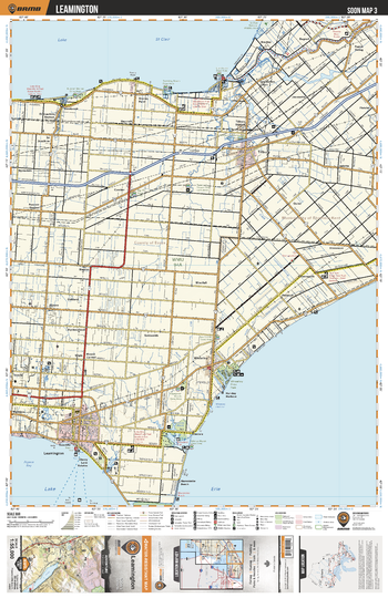
SOON03 Leamington - Southern Ontario Topo
Backroad Mapbooks
This recreation topographic map for Leamington highlights all the logging/resource roads, hunting areas, fishing lakes & streams, campsites, paddling routes for canoeing and kayaking, wildlife viewing areas, multi-use trails for hiking, biking, horseback riding, cross-country skiing and snowshoeing, motorized trails for ATVing and snowmobiling & more. Covering 1,325 km2 (510 mi2), this 1:55,000 scale map measures 31.5 x 42 km (19.5 x 26 mi), providing you with more topographic and recreational detail for the Detroit River area than any other map on the market. New features include expanded road and trail data and countless recreational Points of Interest. Included on this map are Leamington, Lake Erie, Lake St Clair, Wheatley Provincial Park, Thames River, Tilbury, Jeannettes Creek, Baptiste Creek and more!
Page Size: 24 x 37 in (610 x 940 mm)
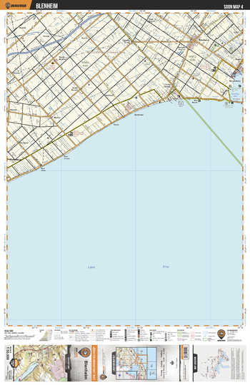
SOON04 Blenheim - Southern Ontario Topo
Backroad Mapbooks
This recreation topographic map for Blenheim highlights all the logging/resource roads, hunting areas, fishing lakes & streams, campsites, paddling routes for canoeing and kayaking, wildlife viewing areas, multi-use trails for hiking, biking, horseback riding, cross-country skiing and snowshoeing, motorized trails for ATVing and snowmobiling & more. Covering 1,325 km2 (510 mi2), this 1:55,000 scale map measures 31.5 x 42 km (19.5 x 26 mi), providing you with more topographic and recreational detail for the Detroit River area than any other map on the market. New features include expanded road and trail data and countless recreational Points of Interest. Included on this map are Blenheim, Lake Erie, Shrewsbury, PortAlma, Port Crewe, Rondeau Bay and more!
Page Size: 24 x 37 in (610 x 940 mm)
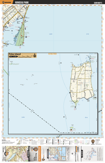
SOON05 Rondeau Park - Southern Ontario Topo
Backroad Mapbooks
This recreation topographic map for Rondeau Park highlights all the logging/resource roads, hunting areas, fishing lakes & streams, campsites, paddling routes for canoeing and kayaking, wildlife viewing areas, multi-use trails for hiking, biking, horseback riding, cross-country skiing and snowshoeing, motorized trails for ATVing and snowmobiling & more. Covering 1,325 km2 (510 mi2), this 1:55,000 scale map measures 31.5 x 42 km (19.5 x 26 mi), providing you with more topographic and recreational detail for the Detroit River area than any other map on the market. New features include expanded road and trail data and countless recreational Points of Interest. Included on this map are Rondeau Provincial Park, Lake Erie, Rondeau Bay, Raglan, Fish Point Provincial Nature Reserve Park, Pelee Island and more!
Page Size: 24 x 37 in (610 x 940 mm)
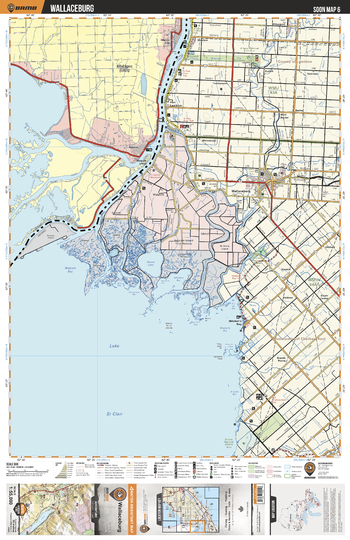
SOON06 Wallaceburg - Southern Ontario Topo
Backroad Mapbooks
This recreation topographic map for Wallaceburg highlights all the logging/resource roads, hunting areas, fishing lakes & streams, campsites, paddling routes for canoeing and kayaking, wildlife viewing areas, multi-use trails for hiking, biking, horseback riding, cross-country skiing and snowshoeing, motorized trails for ATVing and snowmobiling & more. Covering 1,325 km2 (510 mi2), this 1:55,000 scale map measures 31.5 x 42 km (19.5 x 26 mi), providing you with more topographic and recreational detail for the Detroit River area than any other map on the market. New features include expanded road and trail data and countless recreational Points of Interest. Included on this map are Wallaceburg, St. Clair River, North Sydenham River, Goose Lake, Walpole Bay, Mitchell's Bay, Lake St Clair, The Snye River and more!
Page Size: 24 x 37 in (610 x 940 mm)
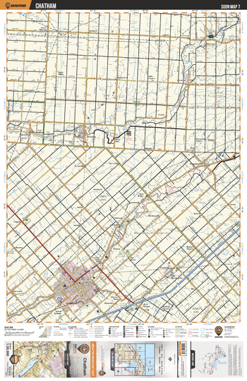
SOON07 Chatham - Southern Ontario Topo
Backroad Mapbooks
This recreation topographic map for Chatham highlights all the logging/resource roads, hunting areas, fishing lakes & streams, campsites, paddling routes for canoeing and kayaking, wildlife viewing areas, multi-use trails for hiking, biking, horseback riding, cross-country skiing and snowshoeing, motorized trails for ATVing and snowmobiling & more. Covering 1,325 km2 (510 mi2), this 1:55,000 scale map measures 31.5 x 42 km (19.5 x 26 mi), providing you with more topographic and recreational detail for the Detroit River area than any other map on the market. New features include expanded road and trail data and countless recreational Points of Interest. Included on this map are Chatham, Thames River, Sydenham River, Shetland, Thamesville, Dresden and more!
Page Size: 24 x 37 in (610 x 940 mm)
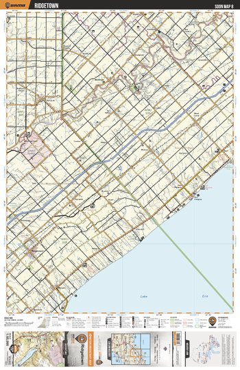
SOON08 Ridgetown - Southern Ontario Topo
Backroad Mapbooks
This recreation topographic map for Ridgetown highlights all the logging/resource roads, hunting areas, fishing lakes & streams, campsites, paddling routes for canoeing and kayaking, wildlife viewing areas, multi-use trails for hiking, biking, horseback riding, cross-country skiing and snowshoeing, motorized trails for ATVing and snowmobiling & more. Covering 1,325 km2 (510 mi2), this 1:55,000 scale map measures 31.5 x 42 km (19.5 x 26 mi), providing you with more topographic and recreational detail for the Detroit River area than any other map on the market. New features include expanded road and trail data and countless recreational Points of Interest. Included on this map are Ridgetown, Lake Erie, Thames River, Port Glasgow, Clearville, Newbury, Glencoe and more!
Page Size: 24 x 37 in (610 x 940 mm)
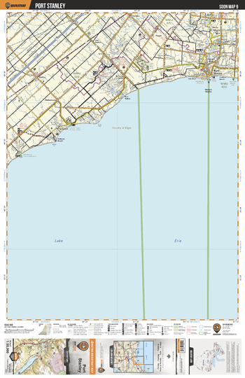
SOON09 Port Stanley - Southern Ontario Topo
Backroad Mapbooks
This recreation topographic map for Port Stanley highlights all the logging/resource roads, hunting areas, fishing lakes & streams, campsites, paddling routes for canoeing and kayaking, wildlife viewing areas, multi-use trails for hiking, biking, horseback riding, cross-country skiing and snowshoeing, motorized trails for ATVing and snowmobiling & more. Covering 1,325 km2 (510 mi2), this 1:55,000 scale map measures 31.5 x 42 km (19.5 x 26 mi), providing you with more topographic and recreational detail for the Detroit River area than any other map on the market. New features include expanded road and trail data and countless recreational Points of Interest. Included on this map are Port Stanley, Lake Erie, Port Stanley Conservation Area, John E Pearce Provincial Park, Mitchell Heights, Orchard Beach, Duttona Beach and more!
Page Size: 24 x 37 in (610 x 940 mm)
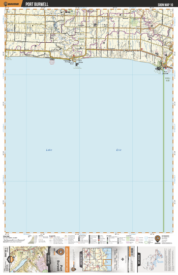
SOON10 Port Burwell - Southern Ontario Topo
Backroad Mapbooks
This recreation topographic map for Port Burwell highlights all the logging/resource roads, hunting areas, fishing lakes & streams, campsites, paddling routes for canoeing and kayaking, wildlife viewing areas, multi-use trails for hiking, biking, horseback riding, cross-country skiing and snowshoeing, motorized trails for ATVing and snowmobiling & more. Covering 1,325 km2 (510 mi2), this 1:55,000 scale map measures 31.5 x 42 km (19.5 x 26 mi), providing you with more topographic and recreational detail for the Detroit River area than any other map on the market. New features include expanded road and trail data and countless recreational Points of Interest. Included on this map are Port Burwell, Port Bruce, Lake Erie, Port Bruce Provincial Park, Port Burwell Provincial Park, Hawk Cliff Wildlife Area and more!
Page Size: 24 x 37 in (610 x 940 mm)
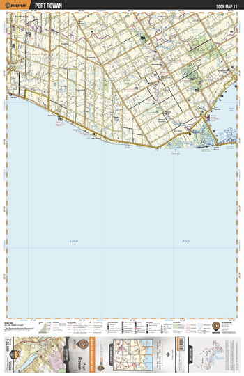
SOON11 Port Rowan - Southern Ontario Topo
Backroad Mapbooks
This recreation topographic map for Port Rowan highlights all the logging/resource roads, hunting areas, fishing lakes & streams, campsites, paddling routes for canoeing and kayaking, wildlife viewing areas, multi-use trails for hiking, biking, horseback riding, cross-country skiing and snowshoeing, motorized trails for ATVing and snowmobiling & more. Covering 1,325 km2 (510 mi2), this 1:55,000 scale map measures 31.5 x 42 km (19.5 x 26 mi), providing you with more topographic and recreational detail for the Detroit River area than any other map on the market. New features include expanded road and trail data and countless recreational Points of Interest. Included on this map are Port Rowan, Lake Erie, Inner Bay, Lee Brown Wildlife Area, Big Creek National Wildlife Area, Long Point Provincial Park and more!
Page Size: 24 x 37 in (610 x 940 mm)
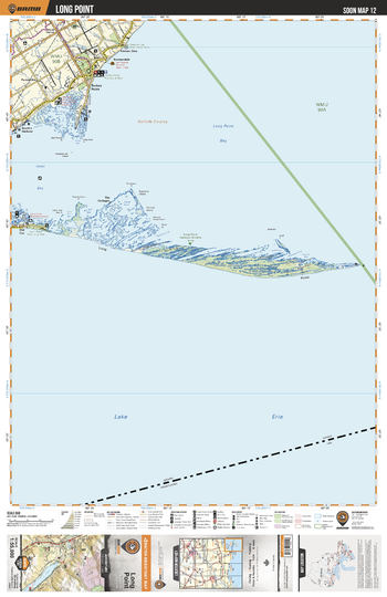
SOON12 Long Point - Southern Ontario Topo
Backroad Mapbooks
This recreation topographic map for Long Point highlights all the logging/resource roads, hunting areas, fishing lakes & streams, campsites, paddling routes for canoeing and kayaking, wildlife viewing areas, multi-use trails for hiking, biking, horseback riding, cross-country skiing and snowshoeing, motorized trails for ATVing and snowmobiling & more. Covering 1,325 km2 (510 mi2), this 1:55,000 scale map measures 31.5 x 42 km (19.5 x 26 mi), providing you with more topographic and recreational detail for the Detroit River area than any other map on the market. New features include expanded road and trail data and countless recreational Points of Interest. Included on this map are Long Point, Long Point National Wildlife Area, Long Point Provincial Park, Lake Erie, Long Point Bay, Turkey Point, Turkey Point Provincial Park and more!
Page Size: 24 x 37 in (610 x 940 mm)
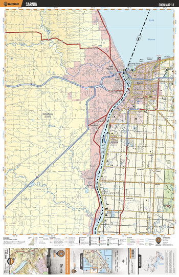
SOON13 Sarnia - Southern Ontario Topo
Backroad Mapbooks
This recreation topographic map for Sarnia highlights all the logging/resource roads, hunting areas, fishing lakes & streams, campsites, paddling routes for canoeing and kayaking, wildlife viewing areas, multi-use trails for hiking, biking, horseback riding, cross-country skiing and snowshoeing, motorized trails for ATVing and snowmobiling & more. Covering 1,325 km2 (510 mi2), this 1:55,000 scale map measures 31.5 x 42 km (19.5 x 26 mi), providing you with more topographic and recreational detail for the Detroit River area than any other map on the market. New features include expanded road and trail data and countless recreational Points of Interest. Included on this map are Sarnia, Lake Huron, St Clair River, Port Huron, Canatara Park, Stag Island Provincial Wildlife Area, Woodrowe Shores, Point Edward and more!
Page Size: 24 x 37 in (610 x 940 mm)
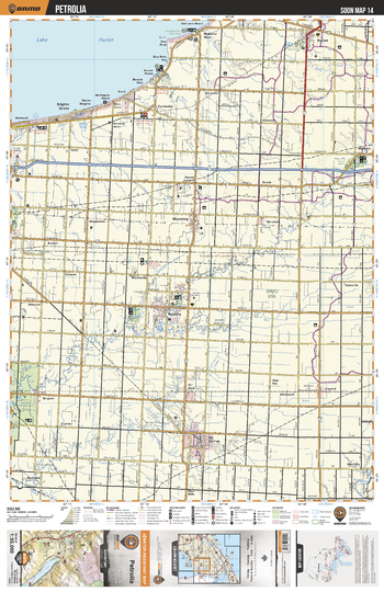
SOON14 Petrolia - Southern Ontario Topo
Backroad Mapbooks
This recreation topographic map for Petrolia highlights all the logging/resource roads, hunting areas, fishing lakes & streams, campsites, paddling routes for canoeing and kayaking, wildlife viewing areas, multi-use trails for hiking, biking, horseback riding, cross-country skiing and snowshoeing, motorized trails for ATVing and snowmobiling & more. Covering 1,325 km2 (510 mi2), this 1:55,000 scale map measures 31.5 x 42 km (19.5 x 26 mi), providing you with more topographic and recreational detail for the Detroit River area than any other map on the market. New features include expanded road and trail data and countless recreational Points of Interest. Included on this map are Petrolia, Lake Huron, Wyoming, Highland Glen, Brights Grove, Forest, Warwick, Bear Creek and more!
Page Size: 24 x 37 in (610 x 940 mm)
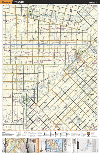
SOON15 Strathroy - Southern Ontario Topo
Backroad Mapbooks
This recreation topographic map for Strathroy highlights all the logging/resource roads, hunting areas, fishing lakes & streams, campsites, paddling routes for canoeing and kayaking, wildlife viewing areas, multi-use trails for hiking, biking, horseback riding, cross-country skiing and snowshoeing, motorized trails for ATVing and snowmobiling & more. Covering 1,325 km2 (510 mi2), this 1:55,000 scale map measures 31.5 x 42 km (19.5 x 26 mi), providing you with more topographic and recreational detail for the Detroit River area than any other map on the market. New features include expanded road and trail data and countless recreational Points of Interest. Included on this map are Strathroy, Ausable River, Rock Glen Conservation Area And Wildlife Centre, Glencoe, Grays, Victoria Park, Sydenham River and more!
Page Size: 24 x 37 in (610 x 940 mm)
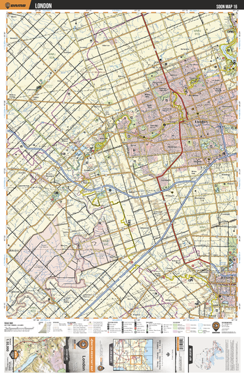
SOON16 London - Southern Ontario Topo
Backroad Mapbooks
This recreation topographic map for London highlights all the logging/resource roads, hunting areas, fishing lakes & streams, campsites, paddling routes for canoeing and kayaking, wildlife viewing areas, multi-use trails for hiking, biking, horseback riding, cross-country skiing and snowshoeing, motorized trails for ATVing and snowmobiling & more. Covering 1,325 km2 (510 mi2), this 1:55,000 scale map measures 31.5 x 42 km (19.5 x 26 mi), providing you with more topographic and recreational detail for the Detroit River area than any other map on the market. New features include expanded road and trail data and countless recreational Points of Interest. Included on this map are London, St Thomas, Thames River, Medway Valley Natural Area, Sifton Bog Conservation Area, Komoka Provincial Park, Pinafore Park and more!
Page Size: 24 x 37 in (610 x 940 mm)
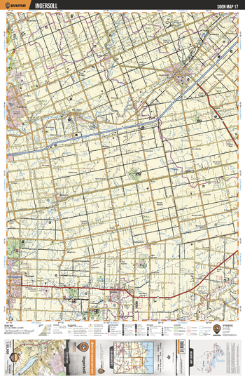
SOON17 Ingersoll - Southern Ontario Topo
Backroad Mapbooks
This recreation topographic map for Ingersoll highlights all the logging/resource roads, hunting areas, fishing lakes & streams, campsites, paddling routes for canoeing and kayaking, wildlife viewing areas, multi-use trails for hiking, biking, horseback riding, cross-country skiing and snowshoeing, motorized trails for ATVing and snowmobiling & more. Covering 1,325 km2 (510 mi2), this 1:55,000 scale map measures 31.5 x 42 km (19.5 x 26 mi), providing you with more topographic and recreational detail for the Detroit River area than any other map on the market. New features include expanded road and trail data and countless recreational Points of Interest. Included on this map are Ingersoll, St Thomas, Fanshawe Lake, Middle Thames River, Dalewood Conservation Area, Aylmer, Aylmer Provincial Wildlife Area and more!
Page Size: 24 x 37 in (610 x 940 mm)
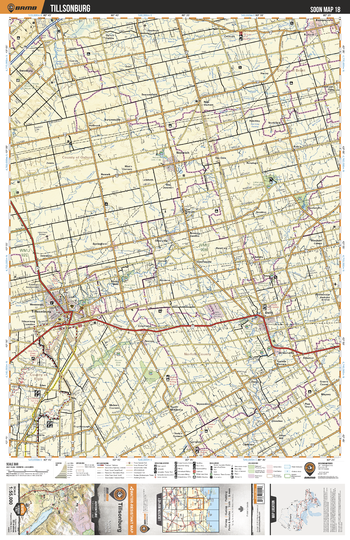
SOON18 Tillsonburg - Southern Ontario Topo
Backroad Mapbooks
This recreation topographic map for Tillsonburg highlights all the logging/resource roads, hunting areas, fishing lakes & streams, campsites, paddling routes for canoeing and kayaking, wildlife viewing areas, multi-use trails for hiking, biking, horseback riding, cross-country skiing and snowshoeing, motorized trails for ATVing and snowmobiling & more. Covering 1,325 km2 (510 mi2), this 1:55,000 scale map measures 31.5 x 42 km (19.5 x 26 mi), providing you with more topographic and recreational detail for the Detroit River area than any other map on the market. New features include expanded road and trail data and countless recreational Points of Interest. Included on this map are Tillsonburg, Dehli, Lake Hunger, Straffordville, Norwich, Tillsonburg Conservation Area, Little Lake Conservation Area and more!
Page Size: 24 x 37 in (610 x 940 mm)
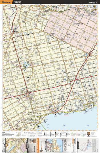
SOON19 Simcoe - Southern Ontario Topo
Backroad Mapbooks
This recreation topographic map for Simcoe highlights all the logging/resource roads, hunting areas, fishing lakes & streams, campsites, paddling routes for canoeing and kayaking, wildlife viewing areas, multi-use trails for hiking, biking, horseback riding, cross-country skiing and snowshoeing, motorized trails for ATVing and snowmobiling & more. Covering 1,325 km2 (510 mi2), this 1:55,000 scale map measures 31.5 x 42 km (19.5 x 26 mi), providing you with more topographic and recreational detail for the Detroit River area than any other map on the market. New features include expanded road and trail data and countless recreational Points of Interest. Included on this map are Simcoe, Lake Erie, Long Point Bay, Port Dover, Lynn River, Waterford, Grand River, Hagersville, Jarvis, Waterford ponds, Keadon Park and more!
Page Size: 24 x 37 in (610 x 940 mm)
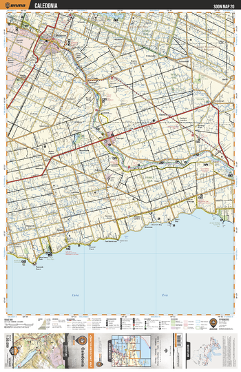
SOON20 Caledonia - Southern Ontario Topo
Backroad Mapbooks
This recreation topographic map for Caledonia highlights all the logging/resource roads, hunting areas, fishing lakes & streams, campsites, paddling routes for canoeing and kayaking, wildlife viewing areas, multi-use trails for hiking, biking, horseback riding, cross-country skiing and snowshoeing, motorized trails for ATVing and snowmobiling & more. Covering 1,325 km2 (510 mi2), this 1:55,000 scale map measures 31.5 x 42 km (19.5 x 26 mi), providing you with more topographic and recreational detail for the Detroit River area than any other map on the market. New features include expanded road and trail data and countless recreational Points of Interest. Included on this map are Caledonia, Cayuga, Kohler, Peacock Point, Lake Erie, Bookers Bay, Canfield, Willow Grove, York, Grand River and more!
Page Size: 24 x 37 in (610 x 940 mm)
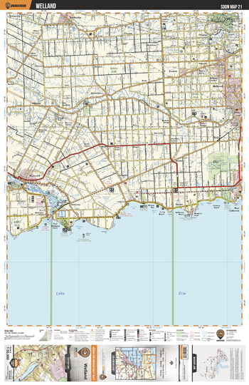
SOON21 Welland - Southern Ontario Topo
Backroad Mapbooks
This recreation topographic map for Welland highlights all the logging/resource roads, hunting areas, fishing lakes & streams, campsites, paddling routes for canoeing and kayaking, wildlife viewing areas, multi-use trails for hiking, biking, horseback riding, cross-country skiing and snowshoeing, motorized trails for ATVing and snowmobiling & more. Covering 1,325 km2 (510 mi2), this 1:55,000 scale map measures 31.5 x 42 km (19.5 x 26 mi), providing you with more topographic and recreational detail for the Detroit River area than any other map on the market. New features include expanded road and trail data and countless recreational Points of Interest. Included on this map are Lake Erie, Grand River, Port Maitland, Long Beach, Port Colborne, Welland, Smithville, Oswego Park, Marshville, Lowbanks, Dunnville, Dils Lak and more!
Page Size: 24 x 37 in (610 x 940 mm)
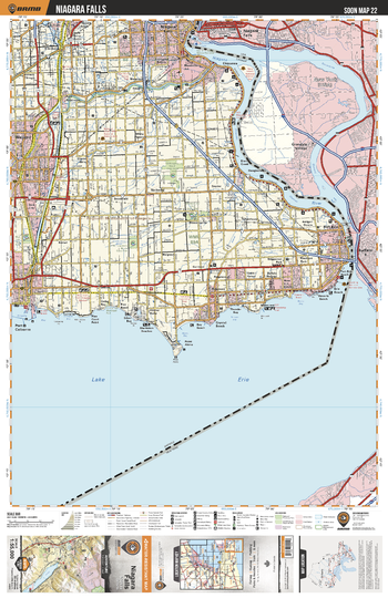
SOON22 Niagra Falls - Southern Ontario Topo
Backroad Mapbooks
This recreation topographic map for Niagra Falls highlights all the logging/resource roads, hunting areas, fishing lakes & streams, campsites, paddling routes for canoeing and kayaking, wildlife viewing areas, multi-use trails for hiking, biking, horseback riding, cross-country skiing and snowshoeing, motorized trails for ATVing and snowmobiling & more. Covering 1,325 km2 (510 mi2), this 1:55,000 scale map measures 31.5 x 42 km (19.5 x 26 mi), providing you with more topographic and recreational detail for the Detroit River area than any other map on the market. New features include expanded road and trail data and countless recreational Points of Interest. Included on this map are Lake Erie, Niagara River, Niagara Falls, Fort Erie, Dain City, Welland Canal, Power Canal, Allanburg, Welland River, Netherby and more!
Page Size: 24 x 37 in (610 x 940 mm)
No search results