


MapSherpa Catalog
Australia's Outback Tracks - 1:1M map
Westprint
Australia’s Outback Tracks map is based on 1:1 million scale data featuring Coast to Coast coverage. Perfect for the creation of personalized maps of past or future trips, regional level interest maps or areas not covered by other printed maps. This file includes all the outback tracks, highways, cities & towns with shaded relief and informative notes about travelling in the outback. Areas can be selected scaled to suit your requirements. Each map includes projection information and scale bar.
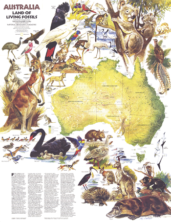
Australia, Land of Living Fossils - Published 1979
National Geographic
This beautiful physical map of Australia and Tasmania includes an introduction to the fascinating wildlife found throughout the continent. Published in February 1979 as a companion to the "Australia" map and the article "Those Kangaroos! They're a Marvelous Mob."
Page Size: 22.75 x 29.5 in (574 x 744 mm)
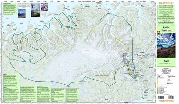
Auyuittuq National Park
GoTrekkers
Auyuittuq National Park
Page Size: 41 x 24 in (1041 x 610 mm)
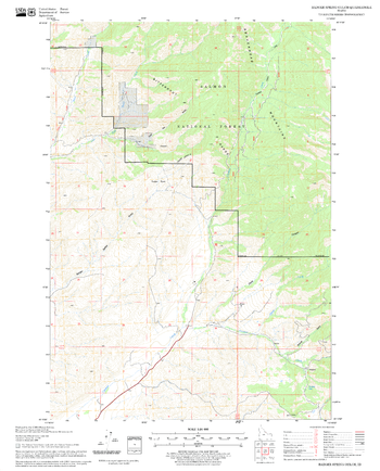
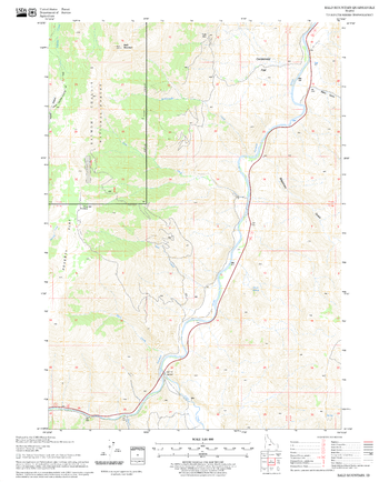
Badger Spring Gulch Quadrangle, Idaho
United States Department of Agriculture Forest Service
United States Department of Agriculture Forestry Service topographical map of Badger Spring Gulch, Salmon-Chalis National Forest, Idaho.
Page Size: 21.75 x 27 in (552 x 686 mm)
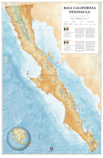
Baja California Peninsula Wall Map – 26 inch
Benchmark Maps
Baja California is an overlander’s paradise. Its network of paved and dirt roads serve the off-road racers, the slow safari-goers, and everyone in between. This wall map illustrates the beauty of the Baja California Peninsula and the roadways and public lands that make it accessible to dreamers from around the world.
Page Size: 25.5 x 39 in (644 x 991 mm)
Bald Mountain Quadrangle, Idaho
United States Department of Agriculture Forest Service
United States Department of Agriculture Forestry Service topographical map of Bald Mountain, Salmon-Chalis National Forest, Idaho.
Page Size: 21.75 x 27 in (552 x 686 mm)
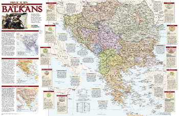
Balkans Conflict - Published 2008
National Geographic
Study the countries of the Balkans with this up-close, detailed look at political boundaries for the region, as well as country flags and facts, history, and helpful inset maps.
Page Size: 31.25 x 20.5 in (794 x 514 mm)
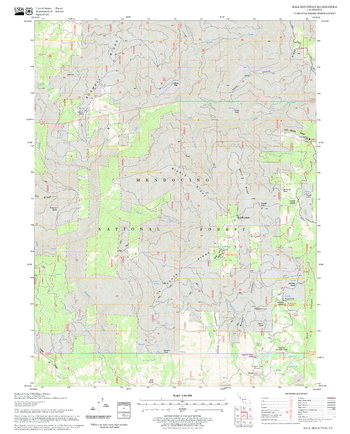
Ball Mountain Quadrangle, California
United States Department of Agriculture Forest Service
United States Department of Agriculture Forestry Service topographical map of Ball Mountain, Mendocino National Forest, California.
Page Size: 21.75 x 27 in (552 x 686 mm)
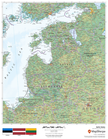
Baltic States
MapSherpa
This beautiful map shows physical and political features for the Baltic States - Estonia, Latvia and Lithuania - and surrounding areas. Relief shading and the use of different colours by height above sea level are both informative and attractive.
Page Size: 17 x 22 in (432 x 559 mm)
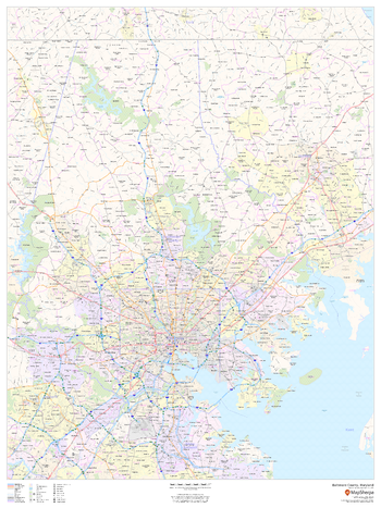
Baltimore County, Maryland
MapSherpa
This map of Baltimore County, Maryland shows regional level information. Base map features include highways and major roads with labelling; neighborhood names; railways; high level land use such as parks and recreation areas, industrial areas and hospital campuses; and a selection of points of interest including transportation hubs like airports and train stations, tourist information, police stations and shopping centres. ZIP code boundaries are shown as a secondary map feature.
Page Size: 36 x 48 in (914 x 1219 mm)
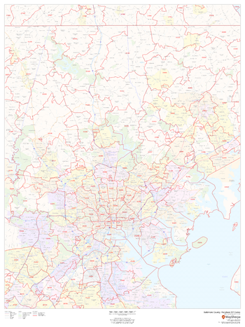
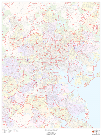
Baltimore County, Maryland ZIP Codes
MapSherpa
This map of Baltimore County, Maryland shows ZIP code areas overlaid on a road map. Ideal for planning of deliveries, home ervices, sales territories, real estate and much more. Base map features include all roads with major roads and highways labelled; neighborhood names; railways; and high level land use such as parks and recreation areas, industrial areas and hospital campuses.
Page Size: 36 x 48 in (914 x 1219 mm)
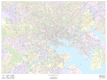
Baltimore, Maryland - Landscape
MapSherpa
This landscape-oriented map of Baltimore, Maryland shows detailed street level information including extensive street labeling. Ideal for planning of deliveries, home services, sales territories, real estate and much more. Base map features include all roads with major roads and highways labelled; neighborhood names; railways; high level land use such as parks and recreation areas, industrial areas and hospital campuses; and a variety of points of interest including schools, libraries, stadiums, museums, border crossings and more.
Page Size: 48 x 36 in (1219 x 914 mm)
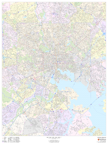
Baltimore, Maryland - Portrait
MapSherpa
This portrait-oriented map of Baltimore, Maryland shows detailed street level information including extensive street labeling. Ideal for planning of deliveries, home services, sales territories, real estate and much more. Base map features include all roads with major roads and highways labelled; neighborhood names; railways; high level land use such as parks and recreation areas, industrial areas and hospital campuses; and a variety of points of interest including schools, libraries, stadiums, museums, border crossings and more.
Page Size: 36 x 48 in (914 x 1219 mm)
Baltimore, Maryland ZIP Codes
MapSherpa
This map of Baltimore shows ZIP code areas overlaid on a road map. Ideal for planning of deliveries, home services, sales territories, real estate and much more. Base map features include all roads with major roads and highways labelled; neighborhood names; railways; and high level land use such as parks and recreation areas, industrial areas and hospital campuses.
Page Size: 36 x 48 in (914 x 1219 mm)
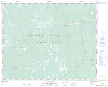
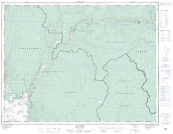
Bambrick Creek - 92 O/11 - British Columbia
Natural Resources Canada
Canadian topographic map of Bambrick Creek, British Columbia. NTS sheet 092O11 Edition 2.
Page Size: 31.75 x 25.5 in (800 x 642 mm)
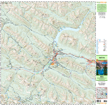
Banff & Area
GoTrekkers
Banff & Area
Page Size: 41 x 39.75 in (1041 x 1008 mm)
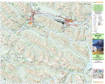
Banff Canmore Area
GoTrekkers
Banff Canmore Area
Page Size: 39.75 x 31.5 in (1007 x 800 mm)
Bankeir - 92 H/9 - British Columbia
Natural Resources Canada
Canadian topographic map of Bankeir, British Columbia. NTS sheet 092H09 Edition 2.
Page Size: 32.75 x 25.5 in (826 x 643 mm)
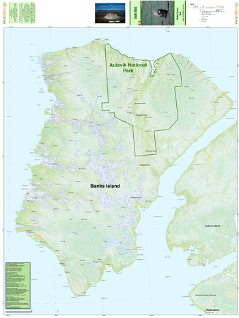
Banks Island
GoTrekkers
Banks Island
Page Size: 41.5 x 55 in (1049 x 1391 mm)
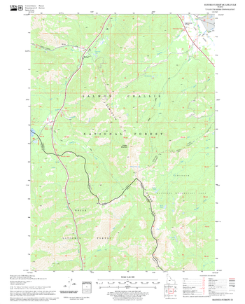
Banner Summit Quadrangle, Idaho
United States Department of Agriculture Forest Service
United States Department of Agriculture Forestry Service topographical map of Banner Summit, Salmon-Chalis National Forest, Idaho.
Page Size: 21.75 x 27 in (552 x 686 mm)
No search results