


MapSherpa Catalog
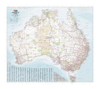
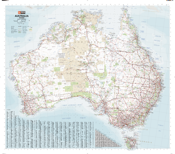
Australia Handy Map
Hema Maps
A country map of Australia that includes city maps for compact travel use.
ISBN 9781925195538
Page Size: 30.25 x 25.25 in (766 x 641 mm)
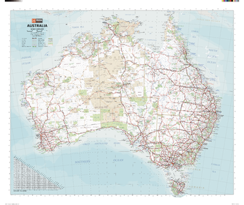
Australia Large Map
Hema Maps
This popular wall map of Australia provides details of the national road network. Towns and rail lines are easy to identify. Suitable for both business and home.
ISBN 9781925195514
Page Size: 40 x 35.25 in (1016 x 891 mm)
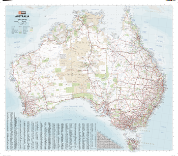
Australia Mega Map
Hema Maps
A giant comprehensive road map of Australia that differentiates between major, minor, sealed and unsealed roads to make an intricately relevant account of Australia for travellers and tourers.
Page Size: 65.5 x 57.5 in (1660 x 1455 mm)
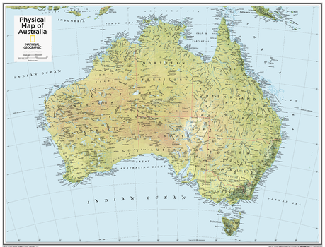
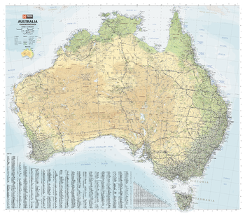
Australia Physical - Atlas of the World, 10th Edition
National Geographic
null
Page Size: 28 x 22 in (711 x 559 mm)
Australia Physical - Atlas of the World, 10th Edition - Compact
National Geographic
Page Size: 21 x 16 in (533 x 406 mm)
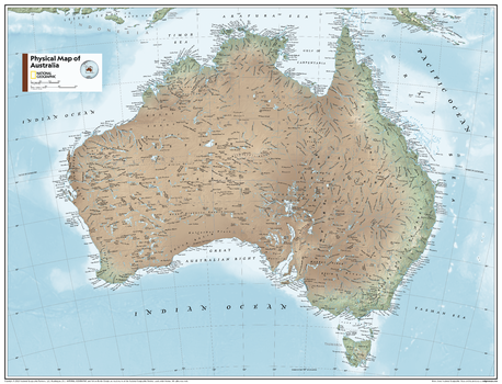
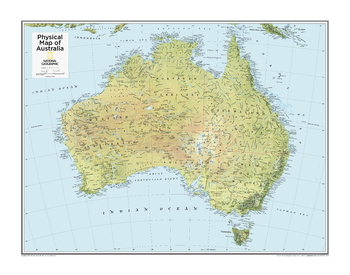
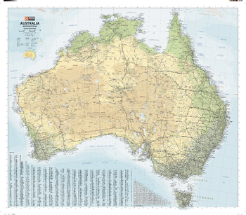
Australia Physical - Atlas of the World, 11th Edition
National Geographic
This physical map of Australia can fit in any space. Showcasing the country in stunning detail with state-of-the-art cartographic techniques delivering accuracy and exceptional quality, the innovative and engaging design makes the content easily accessible and user-friendly.
Ideal for classrooms with an emphasis on teaching geography or environmental themes. The inclusion of physical features gives your students a genuine feel for how our world appears.
This map uses a bright, easy to read color palette featuring blue oceans and stunning shaded relief that has been featured on National Geographic wall maps for over 75 years. Drawn in the Azimuthal Equidistant projection, this map ensures that all points on the map are at proportionally correct distances from the center point.
This map is found in National Geographic's 11th Edition World Atlas and is now available as a stand alone product.
Page Size: 31.5 x 24 in (798 x 610 mm)
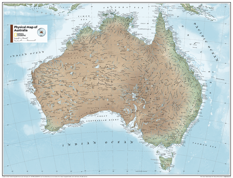
Australia Physical - Atlas of the World, 11th Edition - Compact
National Geographic
This physical map of Australia can fit in any space. Showcasing the country in stunning detail with state-of-the-art cartographic techniques delivering accuracy and exceptional quality, the innovative and engaging design makes the content easily accessible and user-friendly.
Ideal for classrooms with an emphasis on teaching geography or environmental themes. The inclusion of physical features gives your students a genuine feel for how our world appears.
This map uses a bright, easy to read color palette featuring blue oceans and stunning shaded relief that has been featured on National Geographic wall maps for over 75 years. Drawn in the Azimuthal Equidistant projection, this map ensures that all points on the map are at proportionally correct distances from the center point.
This map is found in National Geographic's 11th Edition World Atlas and is now available as a stand alone product.
Page Size: 21.5 x 16.25 in (540 x 413 mm)

Australia Political - Atlas of the World, 10th Edition
National Geographic
null
Page Size: 28 x 22 in (711 x 559 mm)
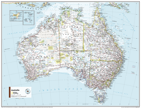
Australia Political - Atlas of the World, 11th Edition
National Geographic
This Australia map of physical and political features can fit in any space. Showcasing the country in stunning detail with state-of-the-art cartographic techniques delivering accuracy and exceptional quality, the innovative and engaging design makes the content easily accessible and user-friendly.
Ideal for classrooms with an emphasis on teaching geography or environmental themes. The inclusion of physical features gives your students a genuine feel for how our world appears.
This map uses a bright, easy to read color palette featuring blue oceans and stunning shaded relief that has been featured on National Geographic wall maps for over 75 years. Drawn in the Azimuthal Equidistant projection, this map ensures that all points on the map are at proportionally correct distances from the center point. Insets of the Cocos Islands and Christmas Island add detail to this classic map.
This map is found in National Geographic's 11th Edition World Atlas and is now available as a stand alone product.
Page Size: 31.5 x 24 in (798 x 610 mm)

Australia Political - Atlas of the World, 11th Edition - Compact
National Geographic
This Australia map of physical and political features can fit in any space. Showcasing the country in stunning detail with state-of-the-art cartographic techniques delivering accuracy and exceptional quality, the innovative and engaging design makes the content easily accessible and user-friendly.
Ideal for classrooms with an emphasis on teaching geography or environmental themes. The inclusion of physical features gives your students a genuine feel for how our world appears.
This map uses a bright, easy to read color palette featuring blue oceans and stunning shaded relief that has been featured on National Geographic wall maps for over 75 years. Drawn in the Azimuthal Equidistant projection, this map ensures that all points on the map are at proportionally correct distances from the center point. Insets of the Cocos Islands and Christmas Island add detail to this classic map.
This map is found in National Geographic's 11th Edition World Atlas and is now available as a stand alone product.
Page Size: 21.5 x 16.25 in (540 x 413 mm)
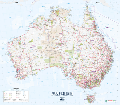
Australia Poster Map in Chinese
Spatial Vision
Australia Poster Map in Chinese
Page Size: 39.75 x 34.75 in (1006 x 881 mm)
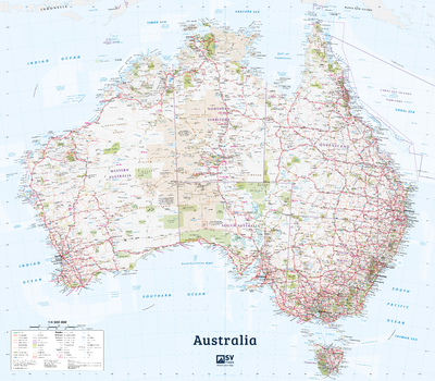
Australia Poster Map in English
Spatial Vision
Australia Poster Map in English
Page Size: 39.5 x 34.5 in (1000 x 875 mm)
Australia Road & Terrain Mega Map
Hema Maps
A picturesque map of Australia that is ideal as a wall map for trip planning, decoration and education. Climate zones are coloured to easily show the variances in temperature and rainfall across the country.
Page Size: 65.5 x 57.5 in (1660 x 1455 mm)
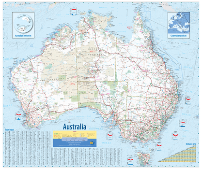
Australia Road & Terrain Wall Map
Hema Maps
A large map of Australia with the country's major road networks shown, along with Outback fuel, distances and major national parks. Climate zones are coloured to easily show the variances in temperature and rainfall across the country.
Ideal gift for a traveller to Australia who recently experienced the incredible variety of sites around the country.
ISBN 9781925195552
Page Size: 40 x 35.25 in (1016 x 891 mm)
Australia Supermap
Hema Maps
An extra-large map of Australia that is perfect for education, reference and decorative purposes. Ideal as a reference and trip planning tool, with the country's major road networks featured along with Outback fuel, distances and major national parks marked on the map.
Page Size: 54.75 x 48 in (1386 x 1216 mm)
Australia Wall Map
Hardie Grant
Australia map-this clear and easy to read map of Australia in a lamberts conformal conic projection features major cities & towns with a population and an index for easy reference. Roads include distances between towns, route numbering, national parks & reserves plus much more.
Page Size: 36.25 x 27.25 in (920 x 690 mm)
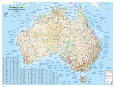
Australia Wall Map - 3rd Edition
Meridian Maps
An award winning map of Australia. Clearly marked on the map are all the nation’s top tourist sites, parks, and points of interest. This easy to read map includes Distance Grids, Time Zone Clocks and Weather Charts of all the capital cities. The map includes an inset maps of Australia’s Territories and a country comparison with Europe.
Page Size: 39.5 x 33.25 in (1000 x 840 mm)
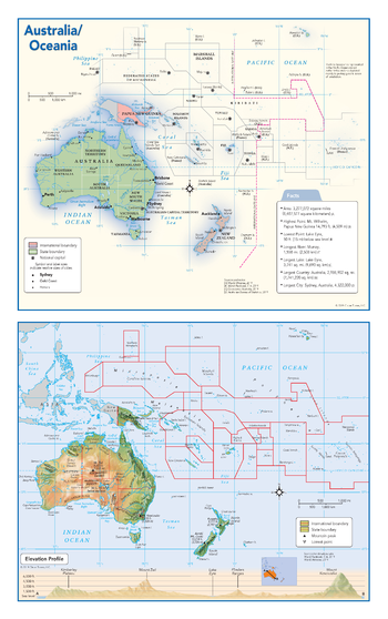
Australia and Oceania Political & Physical Continent Map
Globe Turner
This map of the Australian continent and Oceania combines two maps in one - a vivid political map of Australia and Oceania showing all of the countries and major cities as well as a colorful topographic physical map depicting all of the major physical features in Australia and Oceania, including a cross-continent elevation profile. The political map includes a call-out box with interesting facts about the continent.
Page Size: 10.75 x 17 in (271 x 432 mm)
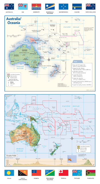
Australia and Oceania Political & Physical Continent Map with Country Flags
Globe Turner
This map of the Australian continent and Oceania combines two maps in one - a vivid political map of Australia and Oceania showing all of the countries and major cities as well as a colorful topographic physical map depicting all of the major physical features in Australia and Oceania including a cross-continent elevation profile. The political map includes a call-out box with interesting facts about the continent. The map also includes all 14 flags each country that makes up Australia and Oceania.
Page Size: 10.75 x 19.5 in (271 x 495 mm)
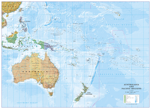
Australia and Pacific Regions
Cosmographics
Political map of Australia and the Pacific Regions on the Van der Grinten projection. Beautifully coloured, detailed mapping showing country borders both on land and at sea and the International dateline. All the islands are named along with capitals, mains cities and towns. The map includes hills on land and ocean depths. Ideal for the home or office.
Page Size: 37.5 x 27 in (950 x 685 mm)
No search results