


MapSherpa Catalog
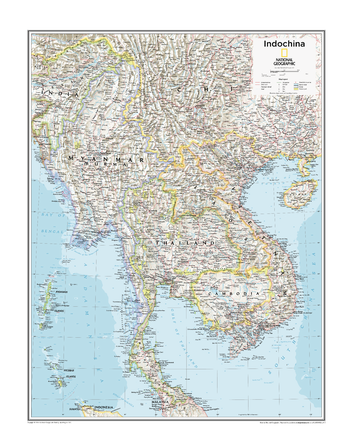
Indochina - Atlas of the World, 10th Edition
National Geographic
Cambodia, Laos, Myanmar (Burma), Thailand, Vietnam
Page Size: 22 x 28 in (559 x 711 mm)
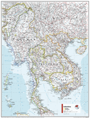
Indochina - Atlas of the World, 11th Edition
National Geographic
This Indochina regional map of physical and political features can fit in any space. Showcasing the region in stunning detail with state-of-the-art cartographic techniques delivering accuracy and exceptional quality, the innovative and engaging design makes the content easily accessible and user-friendly.
Ideal for classrooms with an emphasis on teaching geography or environmental themes. The inclusion of physical features gives your students a genuine feel for how our world appears.
This map uses a bright, easy to read color palette featuring blue oceans and stunning shaded relief that has been featured on National Geographic wall maps for over 75 years. It is drawn in the Oblique Mercator projection, which is a cylindrical map projection for nautical navigation because it represents lines of constant course.
This map is found in National Geographic's 11th Edition World Atlas and is now available as a stand alone product.
Page Size: 24 x 31.5 in (610 x 798 mm)
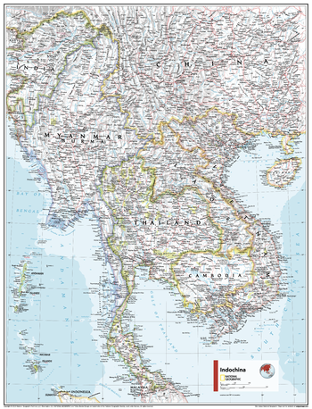
Indochina - Atlas of the World, 11th Edition - Compact
National Geographic
This Indochina regional map of physical and political features can fit in any space. Showcasing the region in stunning detail with state-of-the-art cartographic techniques delivering accuracy and exceptional quality, the innovative and engaging design makes the content easily accessible and user-friendly.
Ideal for classrooms with an emphasis on teaching geography or environmental themes. The inclusion of physical features gives your students a genuine feel for how our world appears.
This map uses a bright, easy to read color palette featuring blue oceans and stunning shaded relief that has been featured on National Geographic wall maps for over 75 years. It is drawn in the Oblique Mercator projection, which is a cylindrical map projection for nautical navigation because it represents lines of constant course.
This map is found in National Geographic's 11th Edition World Atlas and is now available as a stand alone product.
Page Size: 16.25 x 21.5 in (413 x 540 mm)

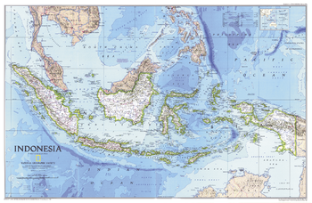
Indonesia
MapSherpa
This beautiful map shows physical and political features for Indonesia and surrounding areas. Relief shading and the use of different colours by height above sea level are both informative and attractive.
Page Size: 48 x 36 in (1219 x 914 mm)
Indonesia - Published 1996
National Geographic
This vibrant map of Indonesia features subtle relief shading of mountainous regions and ocean bathymetry. Published in February 1996 as half of a two–map set with "Indonesia Theme", and accompanied by the article "Irian Jaya: Indonesia's Wild Side."
Page Size: 31.25 x 20.25 in (789 x 513 mm)
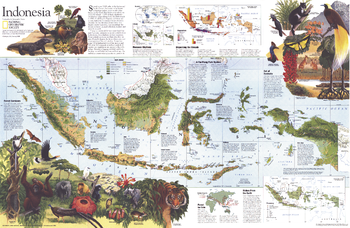
Indonesia Theme - Published 1996
National Geographic
Explore a fascinating land of unique animal species, the world's largest flower, and butterflies with foot-wide wingspans, with this beautiful and educational map of Indonesia. Published in February 1996 as half of a two–map set with "Indonesia", and accompanied by the article "Irian Jaya: Indonesia's Wild Side."
Page Size: 31.25 x 20.25 in (789 x 513 mm)
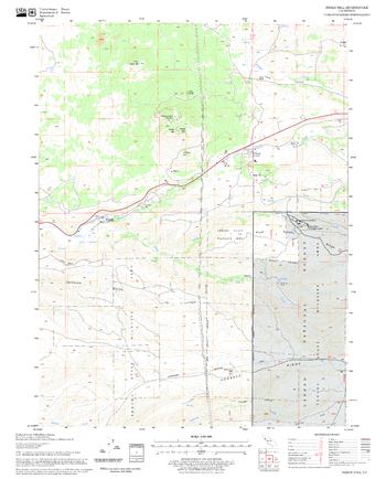
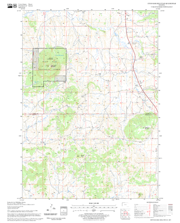
Inskip Hill Quadrangle, California
United States Department of Agriculture Forest Service
United States Department of Agriculture Forestry Service topographical map of Inskip Hill, Lassen National Forest, California.
Page Size: 21.75 x 27 in (552 x 686 mm)
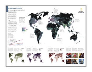
Interconnectivity: An Expanding Information Society - Atlas of the World, 10th Edition
National Geographic
Connecting to the Internet; Global Growth; ICT Development Index; Booming Mobile-Cellular Subscriptions; Internet Access; Evolving Use of Technologies
Page Size: 28 x 22 in (711 x 559 mm)
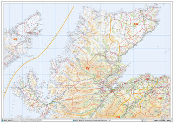
Inverness - IV - Postcode Wall Map
XYZ Maps
The Inverness Postcode Sector Wall Map shows detailed postcode sector boundaries (IV1 1, IV1 2) on a comprehensive background and is perfect for determining postcode boundaries for sales areas, planning mailshots and also an excellent reference for logistics. This wall map covers the whole of the IV Postcode Area.
Page Size: 47 x 33.25 in (1189 x 841 mm)
Inyan Kara Mountain Quadrangle, South Dakota
United States Department of Agriculture Forest Service
United States Department of Agriculture Forestry Service topographical map of Inyan Kara Mountain, Black Hills National Forest, South Dakota.
Page Size: 21.75 x 27 in (552 x 686 mm)
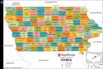
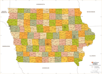
Iowa Counties Map - Extra Large
MapSherpa
This map has been created exclusively for MapSherpa, and designed for reference or business use. Clear and clean colors & fonts matched with cartographic research makes this map of the 99 Iowa counties easily readable and useful.
Page Size: 60 x 40 in (1524 x 1013 mm)

Iowa Counties Map - Large
MapSherpa
This map has been created exclusively for MapSherpa, and designed for reference or business use. Clear and clean colors & fonts matched with cartographic research makes this map of the 99 Iowa counties easily readable and useful.
Page Size: 48 x 32 in (1219 x 810 mm)

Iowa Counties Map - Standard
MapSherpa
This map has been created exclusively for MapSherpa, and designed for reference or business use. Clear and clean colors & fonts matched with cartographic research makes this map of the 99 Iowa counties easily readable and useful.
Page Size: 36 x 24 in (914 x 608 mm)
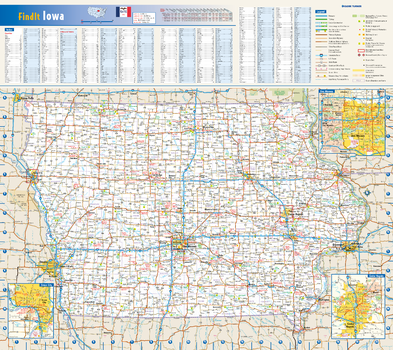
Iowa State Wall Map
Globe Turner
This colorful, easy-to-read state map of Iowa identifies all major thoroughfares, secondary roads, freeway interchanges, rest areas, distance markers, landmarks, recreational areas, and more. Shaded relief on the state map provides a three-dimensional sense of Iowa's topography. Detailed inset maps of Cedar Rapids, Des Moines, and Sioux City are based on the latest street information from our cartographic experts. County and city indices make it simple to locate even the smallest town.
Page Size: 20.75 x 18.5 in (524 x 467 mm)
Iowa ZIP Code Map
MapSherpa
This map of Iowa shows ZIP codes overlaid on a road map. Base map features include municipality and county boundaries, major road network features, and state and national parks and conservation areas.
Page Size: 48 x 36 in (1219 x 914 mm)

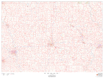
Iowa ZIP Code Map with Counties - Extra Large
MapSherpa
This map has been created exclusively for MapSherpa, and designed for business or reference use. Clear and clean colors & fonts matched with cartographic research makes this map of Iowa's counties and ZIP codes easily readable and useful.
Page Size: 60 x 43.5 in (1524 x 1099 mm)
Iowa ZIP Code Map with Counties - Large
MapSherpa
This map has been created exclusively for MapSherpa, and designed for business or reference use. Clear and clean colors & fonts matched with cartographic research makes this map of Iowa's counties and ZIP codes easily readable and useful.
Page Size: 48 x 34.75 in (1219 x 879 mm)

Iowa ZIP Code Map with Counties - Standard
MapSherpa
This map has been created exclusively for MapSherpa, and designed for business or reference use. Clear and clean colors & fonts matched with cartographic research makes this map of Iowa's counties and ZIP codes easily readable and useful.
Page Size: 36 x 26 in (914 x 659 mm)
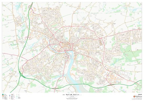
Ipswich
MapSherpa
This map of Ipswich shows detailed street level information including extensive street labelling. Ideal for planning of deliveries, home services, sales territories, real estate and much more.
Page Size: 47 x 33.25 in (1189 x 841 mm)
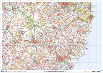
Ipswich - IP - Postcode Wall Map
XYZ Maps
The Ipswich Postcode Sector Wall Map shows detailed postcode sector boundaries (IP1 1, IP1 2) on a comprehensive background and is perfect for determining postcode boundaries for sales areas, planning mailshots and also an excellent reference for logistics. This wall map covers the whole of the IP Postcode Area.
Page Size: 47 x 33.25 in (1189 x 841 mm)
No search results