


MapSherpa Catalog
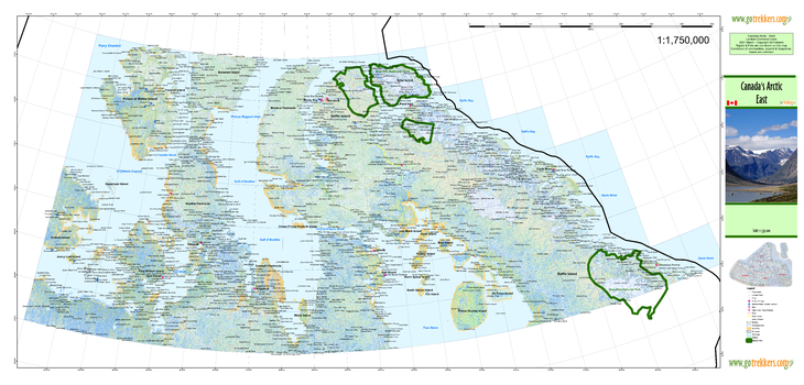
Arctic 3 East
GoTrekkers
Arctic 3 East
Page Size: 48 x 23 in (1219 x 584 mm)
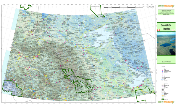
Arctic 4 Southwest
GoTrekkers
Arctic 4 Southwest
Page Size: 41.5 x 24 in (1054 x 610 mm)
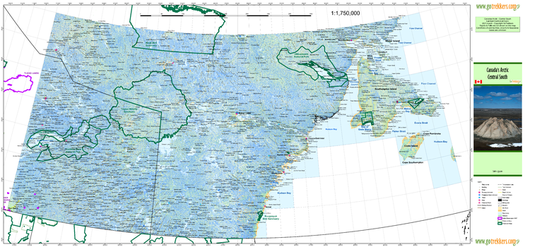
Arctic 5 Southcentral
GoTrekkers
Arctic 5 Southcentral
Page Size: 46 x 21 in (1168 x 533 mm)
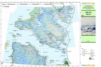
Arctic 6 Southeast
GoTrekkers
Arctic 6 Southeast
Page Size: 28.5 x 19.5 in (721 x 492 mm)
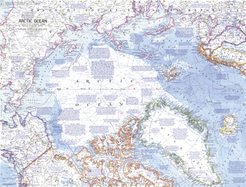
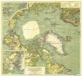
Arctic Ocean - Published 1971
National Geographic
This detailed map of the Arctic Ocean contains a wealth of historical notes, including expedition routes. Published in October 1971 to accompany the "Arctic Ocean Floor" map. Similar in style to ocean maps of the Atlantic (1968) and Pacific (1969).
Page Size: 24.25 x 18.5 in (613 x 467 mm)
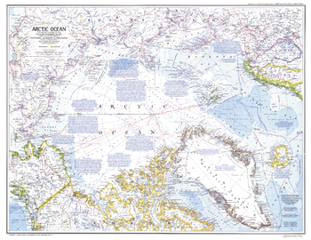
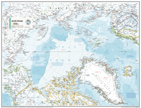
Arctic Ocean - Published 1983
National Geographic
An attractive and informative map of the dramatic and remote Arctic Ocean. Of particular interest is the abundance of historical and geographical notes. Published in February 1983 as a companion to the "Peoples of the Arctic" map and four articles, including "Hunters of the Lost Spirit."
Page Size: 29.5 x 22.75 in (748 x 577 mm)
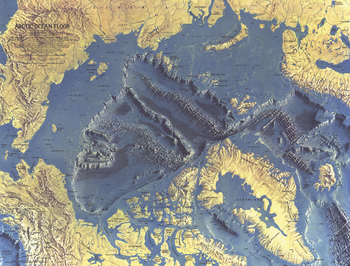
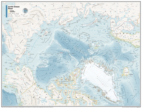
Arctic Ocean Floor - Published 1971
National Geographic
This distinctive physical map of the Arctic Ocean floor provides stunning details of submarine terrain such as continental shelves, abyssal plains, ridges, and fracture zones. Published in October 1971 to accompany the "Arctic Ocean" map.
Page Size: 24.25 x 18.5 in (613 x 467 mm)
Arctic Ocean Floor - Atlas of the World, 10th Edition
National Geographic
null
Page Size: 28 x 22 in (711 x 559 mm)

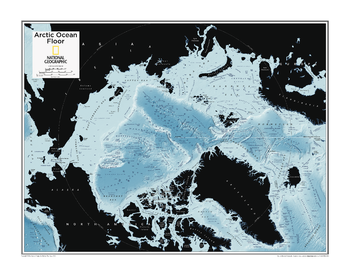
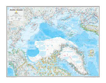
Arctic Ocean Floor - Atlas of the World, 11th Edition
National Geographic
This map of physical features can fit in any space. Showcasing the Arctic Ocean floor in stunning detail with state-of-the-art cartographic techniques delivering accuracy and exceptional quality, the innovative and engaging design makes the content easily accessible and user-friendly.
Ideal for classrooms with an emphasis on teaching geography or environmental themes. The mapping of the ocean terrain gives your students a unique glimpse into how our world appears under the sea.
This physical map of the Arctic Ocean floor uses stunning contrasts to highlight the ocean floor and its physical features. Drawn in the Azimuthal Equidistant projection, this map ensures that all points on the map are at proportionally correct distances from the center point, in this case, the North Pole.
This map is found in National Geographic's 11th Edition World Atlas and is now available as a stand alone product.
Page Size: 31.5 x 24 in (798 x 610 mm)
Arctic Ocean Floor - Atlas of the World, 11th Edition - Compact
National Geographic
This map of physical features can fit in any space. Showcasing the Arctic Ocean floor in stunning detail with state-of-the-art cartographic techniques delivering accuracy and exceptional quality, the innovative and engaging design makes the content easily accessible and user-friendly.
Ideal for classrooms with an emphasis on teaching geography or environmental themes. The mapping of the ocean terrain gives your students a unique glimpse into how our world appears under the sea.
This physical map of the Arctic Ocean floor uses stunning contrasts to highlight the ocean floor and its physical features. Drawn in the Azimuthal Equidistant projection, this map ensures that all points on the map are at proportionally correct distances from the center point, in this case, the North Pole.
This map is found in National Geographic's 11th Edition World Atlas and is now available as a stand alone product.
Page Size: 21.5 x 16.25 in (540 x 413 mm)
Arctic Ocean Political - Atlas of the World, 11th Edition
National Geographic
This map of political features can fit in any space. Showcasing the Arctic Ocean in stunning detail with state-of-the-art cartographic techniques delivering accuracy and exceptional quality, the innovative and engaging design makes the content easily accessible and user-friendly.
Ideal for classrooms with an emphasis on teaching geography or environmental themes. The inclusion of physical features on this map gives your students a genuine feel for how the African continent appears.
This political map of the Arctic Ocean uses a bright, easy to read color palette featuring blue oceans and stunning shaded relief that has been featured on National Geographic wall maps for over 75 years.
Names of geographic features such as international boundaries, cities, rivers and lakes are carefully placed on the map to maintain legibility.
This map is found in National Geographic's 11th Edition World Atlas and is now available as a stand alone product.
Page Size: 31.5 x 24 in (798 x 610 mm)

Arctic Ocean Political - Atlas of the World, 11th Edition - Compact
National Geographic
This map of political features can fit in any space. Showcasing the Arctic Ocean in stunning detail with state-of-the-art cartographic techniques delivering accuracy and exceptional quality, the innovative and engaging design makes the content easily accessible and user-friendly.
Ideal for classrooms with an emphasis on teaching geography or environmental themes. The inclusion of physical features on this map gives your students a genuine feel for how the African continent appears.
This political map of the Arctic Ocean uses a bright, easy to read color palette featuring blue oceans and stunning shaded relief that has been featured on National Geographic wall maps for over 75 years.
Names of geographic features such as international boundaries, cities, rivers and lakes are carefully placed on the map to maintain legibility.
This map is found in National Geographic's 11th Edition World Atlas and is now available as a stand alone product.
Page Size: 21.5 x 16.25 in (540 x 413 mm)
Arctic Political - Atlas of the World, 10th Edition
National Geographic
Alaska (U.S.), Canada, Finland, Greenland (Kalaallit Nunaat) (Denmark), Iceland, Norway, Russia, Sweden
Page Size: 28 x 22 in (711 x 559 mm)
Arctic Regions - Published 1925
National Geographic
This bold map of the Arctic regions appeared in National Geographic Magazine in November of 1925 with the article "The MacMillan Arctic Expedition Returns." In this article, the world would discover the man who would soon be the most famous aviator-explorer of the era: Richard E. Byrd. Filled with detailed explorers' routes, this is a wonderful companion to the North Pole Regions map of 1907.
Page Size: 20 x 18.75 in (508 x 475 mm)
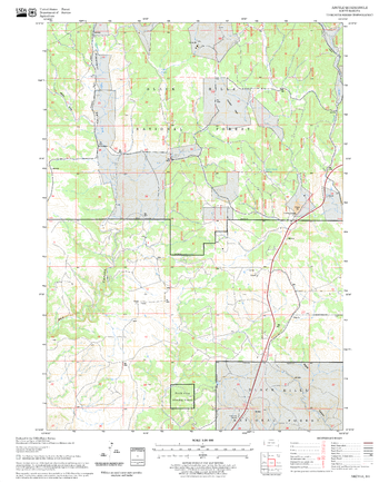
Argyle Quadrangle, South Dakota
United States Department of Agriculture Forest Service
United States Department of Agriculture Forestry Service topographical map of Argyle, Black Hills National Forest, South Dakota.
Page Size: 21.75 x 27 in (552 x 686 mm)
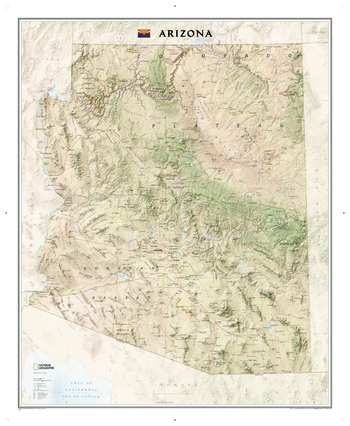
Arizona
National Geographic
The Arizona State Wall Map, part of our growing series of State Wall Maps. Map depicts Arizona's diverse terrain and vegetation. Contains hundreds of place names and precise locations of cities, major roadways and railways, airports, federal and state parks and protected areas, mountain ranges and prominent peaks, military installations, major lakes, rivers and reservoirs, and other geographic features.
Page Size: 34.75 x 42.25 in (878 x 1069 mm)
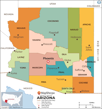
Arizona Counties Map - Extra Large
MapSherpa
This map has been created exclusively for MapSherpa, and designed for reference or business use. Clear and clean colors & fonts matched with cartographic research makes this map of Arizona Counties Map easily readable and useful. The map shows the 15 counties of Arizona and their borders across the Grand Canyon State.
Page Size: 60 x 64.25 in (1524 x 1629 mm)

Arizona Counties Map - Large
MapSherpa
This map has been created exclusively for MapSherpa, and designed for reference or business use. Clear and clean colors & fonts matched with cartographic research makes this map of Arizona Counties Map easily readable and useful. The map shows the 15 counties of Arizona and their borders across the Grand Canyon State.
Page Size: 48 x 51.5 in (1219 x 1303 mm)

Arizona Counties Map - Standard
MapSherpa
This map has been created exclusively for MapSherpa, and designed for reference or business use. Clear and clean colors & fonts matched with cartographic research makes this map of Arizona Counties Map easily readable and useful. The map shows the 15 counties of Arizona and their borders across the Grand Canyon State.
Page Size: 36 x 38.5 in (914 x 977 mm)
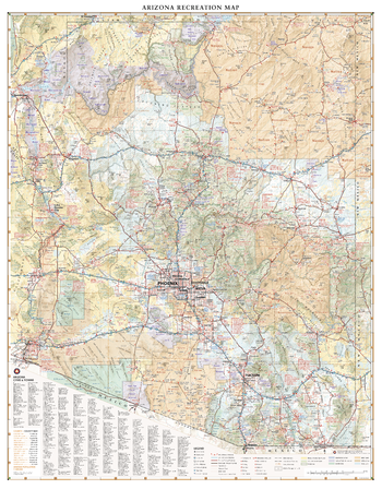
Arizona Recreation Wall Map – 26 inch
Benchmark Maps
Arizona contains some of the world’s most fascinating natural landscapes and scenic drives, from the Grand Canyon in the north to the Sonoran Desert in the south. This wall map illustrates The Grand Canyon State’s vast network highways, public lands, and recreation opportunities.
Page Size: 26 x 33.5 in (660 x 845 mm)
No search results