XYZ Maps
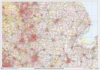
Lincolnshire & Derbyshire Postcode Sector Wall Map (S11)
The Lincolnshire & Derbyshire Postcode Sector Wall Map shows detailed postcode sector boundaries along with its associated label (LN1 1, LN1 2) on a comprehensive background and is perfect for determining postcode boundaries, for sales, logistics, planning mailshots or as a regional reference guide.
Page Size: 47 x 33.25 in (1189 x 841 mm)
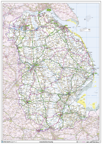
Lincolnshire County Map
This is a large ceremonial county map of Lincolnshire highlighting the county border, with the surrounding area faded out for excellent contrast. The map covers Boston, Bourne, Cleethorpes, Gainsborough, Grantham, Grimsby, Holbeach, Lincoln, Louth, Scunthorpe, Spalding and Stamford. The county map shows the latest County and Unitary Authority Boundaries, Overlaid on a Clear and Easy to Read Ordnance Survey map.
Page Size: 33.25 x 47 in (841 x 1189 mm)
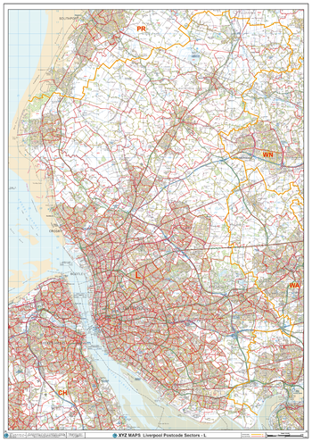
Liverpool - L - Postcode Wall Map
The Liverpool Postcode Sector Wall Map shows detailed postcode sector boundaries (L1 1, L1 2) on a comprehensive background and is perfect for determining postcode boundaries for sales areas, planning mailshots and also an excellent reference for logistics. This wall map covers the whole of the L Postcode Area.
Page Size: 33.25 x 47 in (841 x 1189 mm)
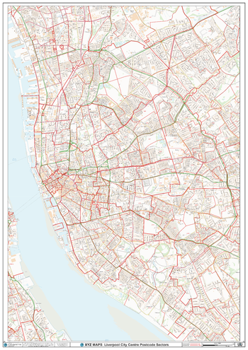
Liverpool City Centre Postcode Sector Wall Map (C2)
The Liverpool City Centre Postcode Sector Wall Map shows detailed postcode sector boundaries along with its associated label (L1 1, L1 2) on a comprehensive background and is perfect for determining postcode boundaries, for sales, logistics, planning mailshots or as a regional reference gGuide.
Page Size: 33.25 x 47 in (841 x 1189 mm)
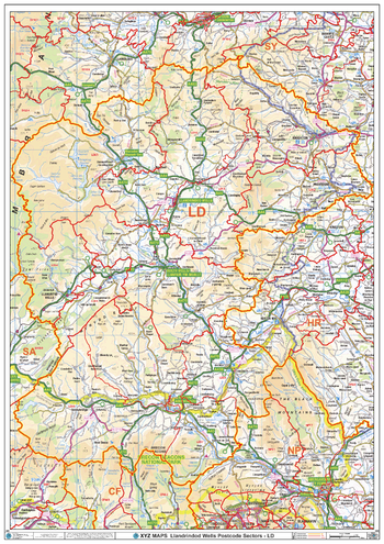
Llandrindod Wells - LD - Postcode Wall Map
The Llandrindod Wells Postcode Sector Wall Map shows detailed postcode sector boundaries (LD1 1, LD1 2) on a comprehensive background and is perfect for determining postcode boundaries for sales areas, planning mailshots and also an excellent reference for logistics. This wall map covers the whole of the LD Postcode Area.
Page Size: 33.25 x 47 in (841 x 1189 mm)
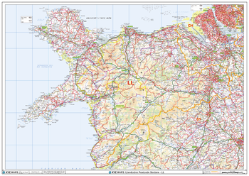
Llandudno - LL - Postcode Wall Map
The Llandudno Postcode Sector Wall Map shows detailed postcode sector boundaries (LL1 1, LL1 2) on a comprehensive background and is perfect for determining postcode boundaries for sales areas, planning mailshots and also an excellent reference for logistics. This wall map covers the whole of the LL Postcode Area.
Page Size: 47 x 33.25 in (1189 x 841 mm)
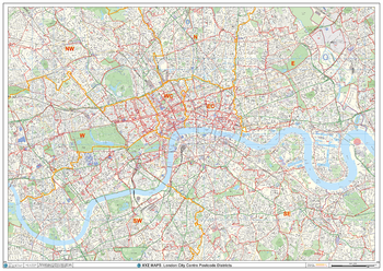
London City Centre Postcode District Wall Map (D12)
The London City Centre Postcode District Map clearly shows postcode district boundaries and associated district labels (SL1, SL2) on a comprehensive background and is perfect for determining postcode boundaries for sales territories, logistics, planning mailshots or as a regional reference guide.
Page Size: 47 x 33.25 in (1189 x 841 mm)
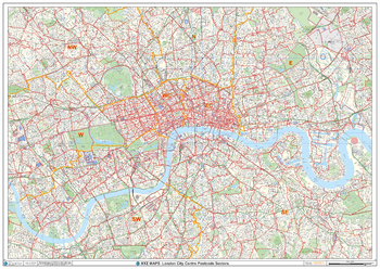
London City Centre Postcode Sectors Wall Map (C1)
The London City Centre Postcode Sectors Wall Map shows detailed postcode sector boundaries along with its associated label (EC1 1, EC1 2) on a comprehensive background and is perfect for determining postcode boundaries, for sales, logistics, planning mailshots or as a regional reference guide.
Page Size: 47 x 33.25 in (1189 x 841 mm)
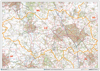
Luton - LU - Postcode Wall Map
The Luton Postcode Sector Wall Map shows detailed postcode sector boundaries (LU1 1, LU1 2) on a comprehensive background and is perfect for determining postcode boundaries for sales areas, planning mailshots and also an excellent reference for logistics. This wall map covers the whole of the LU Postcode Area.
Page Size: 47 x 33.25 in (1189 x 841 mm)
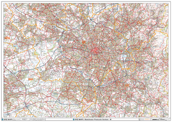
Manchester - M - Postcode Wall Map
The Manchester Postcode Sector Wall Map shows detailed postcode sector boundaries (M1 1, M1 2) on a comprehensive background and is perfect for determining postcode boundaries for sales areas, planning mailshots and also an excellent reference for logistics. This wall map covers the whole of the M Postcode Area.
Page Size: 47 x 33.25 in (1189 x 841 mm)
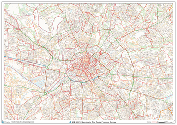
Manchester City Centre Postcode Sector Wall Map (C3)
The Manchester City Centre Postcode Sector Wall Map shows detailed postcode sector boundaries along with its associated label (M1 1, M1 2) on a comprehensive background and is perfect for determining postcode boundaries, for sales, logistics, planning mailshots or as a regional reference guide.
Page Size: 47 x 33.25 in (1189 x 841 mm)
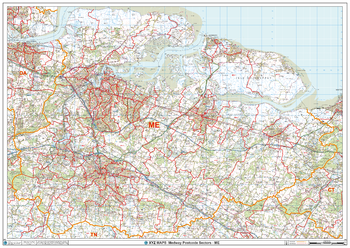
Medway - ME - Postcode Wall Map
The Medway Postcode Sector Wall Map shows detailed postcode sector boundaries (ME1 1, ME1 2) on a comprehensive background and is perfect for determining postcode boundaries for sales areas, planning mailshots and also an excellent reference for logistics. This wall map covers the whole of the ME Postcode Area.
Page Size: 47 x 33.25 in (1189 x 841 mm)
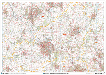
Milton Keynes - MK - Postcode Wall Map
The Milton Keynes Postcode Sector Wall Map shows detailed postcode sector boundaries (MK1 1, MK1 2) on a comprehensive background and is perfect for determining postcode boundaries for sales areas, planning mailshots and also an excellent reference for logistics. This wall map covers the whole of the MK Postcode Area.
Page Size: 47 x 33.25 in (1189 x 841 mm)
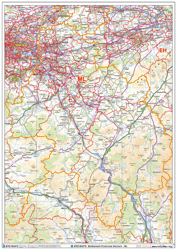
Motherwell - ML - Postcode Wall Map
The Motherwell Postcode Sector Wall Map shows detailed postcode sector boundaries (ML1 1, ML1 2) on a comprehensive background and is perfect for determining postcode boundaries for sales areas, planning mailshots and also an excellent reference for logistics. This wall map covers the whole of the ML Postcode Area.
Page Size: 33.25 x 47 in (841 x 1189 mm)
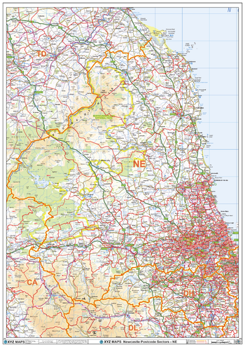
Newcastle - NW - Postcode Wall Map
The Newcastle Postcode Sector Wall Map shows detailed postcode sector boundaries (NW1 1, NW1 2) on a comprehensive background and is perfect for determining postcode boundaries for sales areas, planning mailshots and also an excellent reference for logistics. This wall map covers the whole of the NW Postcode Area.
Page Size: 33.25 x 47 in (841 x 1189 mm)
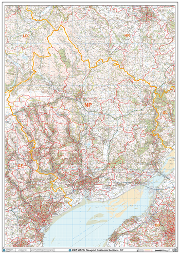
Newport - NP - Postcode Wall Map
The Newport Postcode Sector Wall Map shows detailed postcode sector boundaries (NP1 1, NP1 2) on a comprehensive background and is perfect for determining postcode boundaries for sales areas, planning mailshots and also an excellent reference for logistics. This wall map covers the whole of the NP Postcode Area.
Page Size: 33.25 x 47 in (841 x 1189 mm)
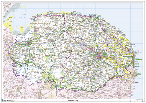
Norfolk County Map
This is a large ceremonial county map of Norfolk highlighting the county border, with the surrounding area faded out for excellent contrast. The map covers Blakeney, Cley-Next-The-Sea, Cromer, Downham Market, East Dereham, Great Witchingham, Great Yarmouth, Kings Lynn, Norwich, Swaffham, Thetford and Wells-Next-The-Sea. The county map shows the latest County and Unitary Authority Boundaries, Overlaid on a Clear and Easy to Read Ordnance Survey map.
Page Size: 47 x 33.25 in (1189 x 841 mm)
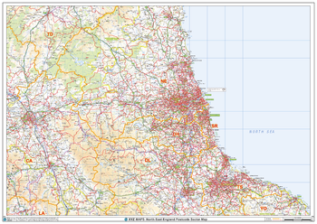
North East England Postcode Sector Wall Map (S16)
The North East England Postcode Sector Wall Map shows detailed postcode sector boundaries along with its associated label (NE1 1, NE1 2) on a comprehensive background and is perfect for determining postcode boundaries, for sales, logistics, planning mailshots or as a regional reference guide.
Page Size: 47 x 33.25 in (1189 x 841 mm)
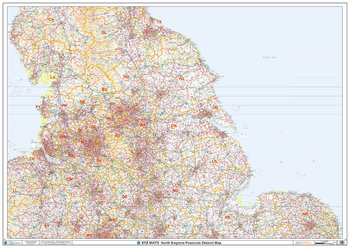
North England Postcode District Wall Map (D4)
This North England Postcode District Map clearly shows postcode district boundaries and associated district labels (LS1, LS2) on a comprehensive background and is perfect for determining postcode boundaries for sales territories, logistics, planning mailshots or as a regional reference guide.
Page Size: 47 x 33.25 in (1189 x 841 mm)
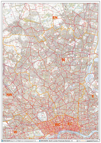
North London - N - Postcode Wall Map
The North London Postcode Sector Wall Map shows detailed postcode sector boundaries (N1 1, N1 2) on a comprehensive background and is perfect for determining postcode boundaries for sales areas, planning mailshots and also an excellent reference for logistics. This wall map covers the whole of the N Postcode Area.
Page Size: 33.25 x 47 in (841 x 1189 mm)