XYZ Maps
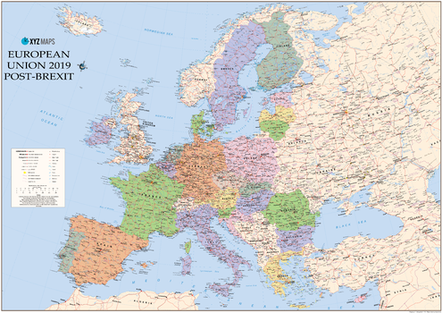
European Union 2019 Post Brexit Wall Map
The European Union 2019 Post-Brexit Political wall map is ideal for the office or educational environment. This unique EU map features political colouring showing Europe and the member countries of the European Union. All major Towns, Roads, Rivers and Lakes are shown on this map. This map shows the British Isles as they will appear once the UK has completed leaving the EU!
Page Size: 47 x 33.25 in (1189 x 841 mm)

Exeter - EX - Postcode Wall Map
The Exeter Postcode Sector Wall Map shows detailed postcode sector boundaries (EX1 1, EX1 2) on a comprehensive background and is perfect for determining postcode boundaries for sales areas, planning mailshots and also an excellent reference for logistics. This wall map covers the whole of the EX Postcode Area.
Page Size: 47 x 33.25 in (1189 x 841 mm)
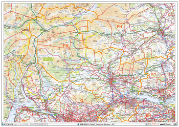
Falkirk - FK - Postcode Wall Map
The Falkirk Postcode Sector Wall Map shows detailed postcode sector boundaries (FK1 1, FK1 2) on a comprehensive background and is perfect for determining postcode boundaries for sales areas, planning mailshots and also an excellent reference for logistics. This wall map covers the whole of the FK Postcode Area.
Page Size: 47 x 33.25 in (1189 x 841 mm)
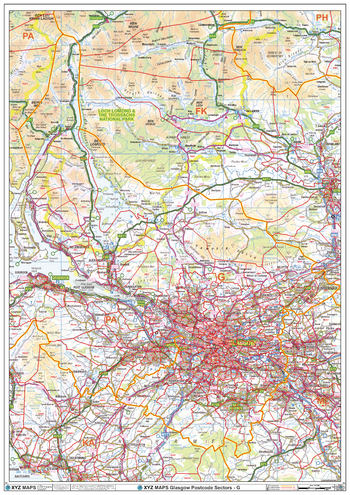
Glasgow - G - Postcode Wall Map
The Glasgow Postcode Sector Wall Map shows detailed postcode sector boundaries (G1 1, G1 2) on a comprehensive background and is perfect for determining postcode boundaries for sales areas, planning mailshots and also an excellent reference for logistics. This wall map covers the whole of the G Postcode Area.
Page Size: 33.25 x 47 in (841 x 1189 mm)
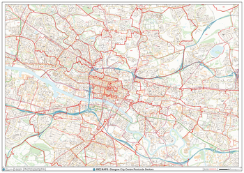
Glasgow City Centre Postcode Sectors Wall Map (C5)
The Glasgow City Centre Postcode Sector Wall Map shows detailed postcode sector boundaries along with its associated label (G1 1, G1 2) on a comprehensive background and is perfect for determining postcode boundaries, for sales, logistics, planning mailshots or as a regional reference guide.
Page Size: 47 x 33.25 in (1189 x 841 mm)
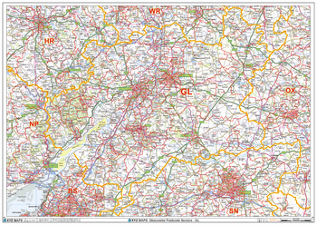
Gloucester - GL - Postcode Wall Map
The Gloucester Postcode Sector Wall Map shows detailed postcode sector boundaries (GL1 1, GL1 2) on a comprehensive background and is perfect for determining postcode boundaries for sales areas, planning mailshots and also an excellent reference for logistics. This wall map covers the whole of the GL Postcode Area.
Page Size: 47 x 33.25 in (1189 x 841 mm)
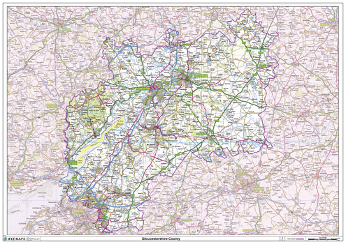
Gloucestershire County Map
This is a large ceremonial county map of Gloucestershire highlighting the county border, with the surrounding area faded out for excellent contrast. The map covers Bristol, Cheltenham, Chipping Campden, Cirencester, Lydney, Nailsworth, Stow-on-the-Wold, Stroud and Tewkesbury. The county map shows the latest County and Unitary Authority Boundaries, Overlaid on a Clear and Easy to Read Ordnance Survey map.
Page Size: 47 x 33.25 in (1189 x 841 mm)
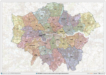
Greater London Authority Boroughs Wall Map
The Greater London Authority Boroughs Wall Map shows the London boroughs within the Greater London Authority, on a comprehensive background. This is perfect for determining the boundaries within the Greater London Authority. Ideal for sales, logistics or a regional reference guide.
Page Size: 47 x 33.25 in (1189 x 841 mm)
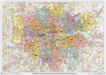
Greater London Authority Boroughs with Postcode Districts Wall Map
This Greater London Authority Boroughs Wall Map shows the London boroughs within the Greater London Authority including detailed postcode district boundaries and labels (UB1) on a comprehensive background. This is perfect for determining the postcode boundaries within the Greater London Authority or vice versa. Ideal for sales, logistics, planning mailshots or a regional reference guide.
Page Size: 47 x 33.25 in (1189 x 841 mm)
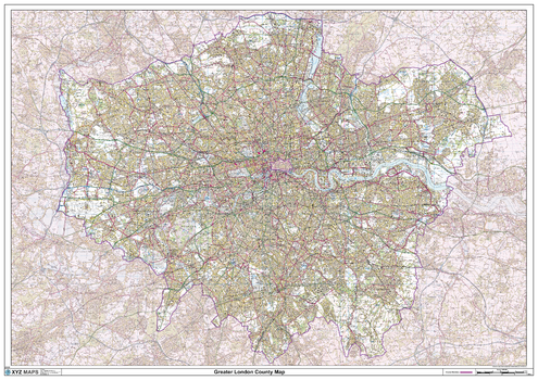
Greater London County Map
This is a large ceremonial county map of Greater London. highlighting the county border, with the surrounding area faded out for excellent contrast. The map covers Enfield, Walthamstow, Harrow, Uxbridge, Kingston Upon Thames, Sutton, Croydon, City of London, Bexley, Dagenham and Romford. The county map shows the latest County and Unitary Authority Boundaries, overlaid on a clear and easy to read Ordnance Survey map.
Page Size: 47 x 33.25 in (1189 x 841 mm)
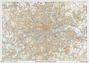
Greater London Postcode Area Wall Map
This Greater London Postcode Areas Map shows Postcode Area Boundaries (NW) on a clear comprhensive colour background and is perfect for sales/franchise planning or as a regional reference guide. This map covers the area within the M25.
Page Size: 47 x 33.25 in (1189 x 841 mm)
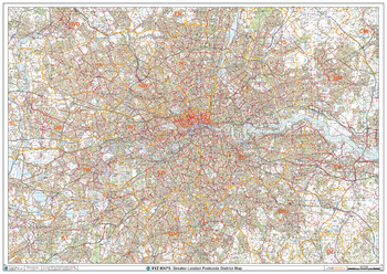
Greater London Postcode District Wall Map (D7)
This Greater London Postcode District Map clearly shows postcode district boundaries and associated district labels (E1, E2) on a comprehensive background and is perfect for determining postcode boundaries for sales territories, logistics, planning mailshots or as a regional reference guide.
Page Size: 47 x 33.25 in (1189 x 841 mm)
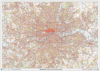
Greater London Postcode Postcode Sector Wall Map (C7)
The Greater London Postcode Postcode Sector Wall Map shows detailed postcode sector boundaries along with its associated label (UB1 1, UB1 2) on a comprehensive background and is perfect for determining postcode boundaries, for sales, logistics, planning mailshots or as a regional reference guide.
Page Size: 47 x 33.25 in (1189 x 841 mm)
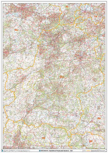
Guildford - GU - Postcode Wall Map
The Guildford Postcode Sector Wall Map shows detailed postcode sector boundaries (GU1 1, GU1 2) on a comprehensive background and is perfect for determining postcode boundaries for sales areas, planning mailshots and also an excellent reference for logistics. This wall map covers the whole of the GU Postcode Area.
Page Size: 33.25 x 47 in (841 x 1189 mm)
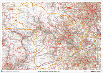
Halifax - HX - Postcode Wall Map
The Halifax Postcode Sector Wall Map shows detailed postcode sector boundaries (HX1 1, HX1 2) on a comprehensive background and is perfect for determining postcode boundaries for sales areas, planning mailshots and also an excellent reference for logistics. This wall map covers the whole of the HX Postcode Area.
Page Size: 47 x 33.25 in (1189 x 841 mm)
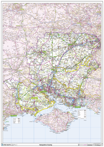
Hampshire County Map
This is a large ceremonial county map of Hampshire highlighting the county border, with the surrounding area faded out for excellent contrast. The map covers Aldershot, Basingstoke, Bournemouth, Christchurch, Cowes, Newport, Petersfield, Portmouth, Ringwood, Ryde, Southampton, Winchester and Ventnor. The county map shows the latest County and Unitary Authority Boundaries, Overlaid on a Clear and Easy to Read Ordnance Survey map.
Page Size: 33.25 x 47 in (841 x 1189 mm)
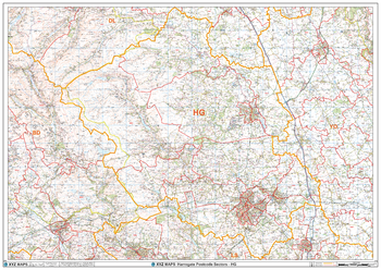
Harrogate - HG - Postcode Wall Map
The Harrogate Postcode Sector Wall Map shows detailed postcode sector boundaries (HG1 1, HG1 2) on a comprehensive background and is perfect for determining postcode boundaries for sales areas, planning mailshots and also an excellent reference for logistics. This wall map covers the whole of the HG Postcode Area.
Page Size: 47 x 33.25 in (1189 x 841 mm)
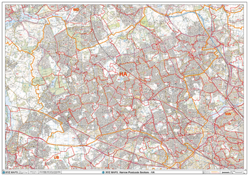
Harrow - HA - Postcode Wall Map
The Harrow Postcode Sector Wall Map shows detailed postcode sector boundaries (HA1 1, HA1 2) on a comprehensive background and is perfect for determining postcode boundaries for sales areas, planning mailshots and also an excellent reference for logistics. This wall map covers the whole of the HA Postcode Area.
Page Size: 47 x 33.25 in (1189 x 841 mm)
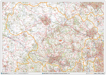
Hemel Hempstead - HP - Postcode Wall Map
The Hemel Hempstead Postcode Sector Wall Map shows detailed postcode sector boundaries (HP1 1, HP1 2) on a comprehensive background and is perfect for determining postcode boundaries for sales areas, planning mailshots and also an excellent reference for logistics. This wall map covers the whole of the HP Postcode Area.
Page Size: 47 x 33.25 in (1189 x 841 mm)
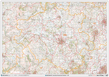
Hereford - HR - Postcode Wall Map
The Hereford Postcode Sector Wall Map shows detailed postcode sector boundaries (HR1 1, HR1 2) on a comprehensive background and is perfect for determining postcode boundaries for sales areas, planning mailshots and also an excellent reference for logistics. This wall map covers the whole of the HR Postcode Area.
Page Size: 47 x 33.25 in (1189 x 841 mm)