United States Department of Agriculture Forest Service
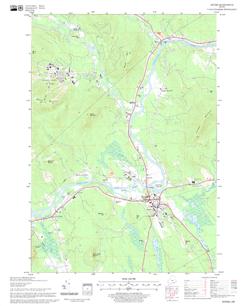
Bethel Quadrangle, New Hampshire-Vermont
United States Department of Agriculture Forestry Service topographical map of Bethel, White Mountains National Forest, New Hampshire-Vermont.
Page Size: 21.75 x 27 in (552 x 686 mm)
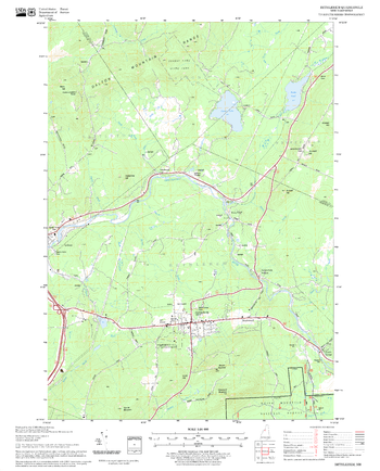
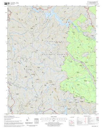
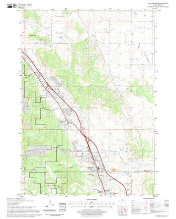
Bethlehem Quadrangle, New Hampshire-Vermont
United States Forestry Service topographical map of Bethlehem, New Hampshire-Vermont
Page Size: 21.75 x 27 in (552 x 686 mm)
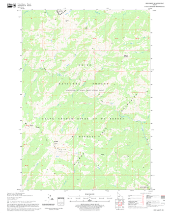
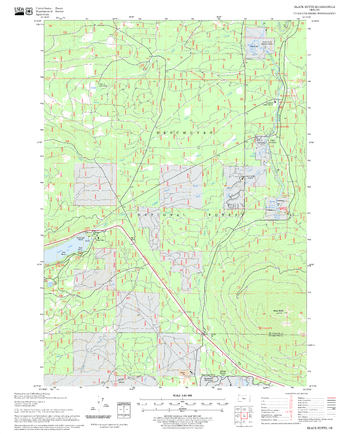
Big Baldy Quadrangle, Idaho
United States Department of Agriculture Forestry Service topographical map of Big Baldy, Salmon-Chalis National Forest, Idaho.
Page Size: 21.75 x 27 in (552 x 686 mm)
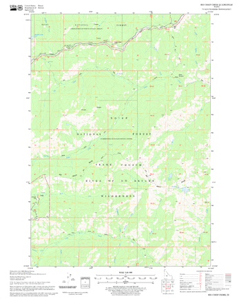
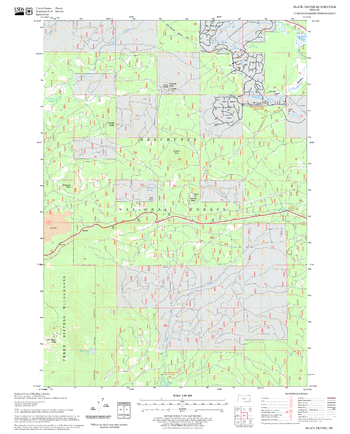
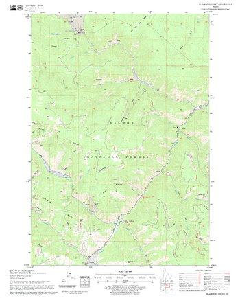
Big Chief Creek Quadrangle, Idaho
United States Department of Agriculture Forestry Service topographical map of Big Chief Creek, Salmon-Chalis National Forest, Idaho.
Page Size: 21.75 x 27 in (552 x 686 mm)
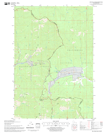
Big Hole Pass Quadrangle, Idaho
United States Department of Agriculture Forestry Service topographical map of Big Hole Pass, Salmon-Chalis National Forest, Idaho.
Page Size: 21.75 x 27 in (552 x 686 mm)
Big Hole Quadrangle, Oregon
United States Department of Agriculture Forestry Service topographical map of Big Hole, Deschutes National Forest, Oregon.
Page Size: 21.75 x 27 in (552 x 686 mm)
Big Ridge Quadrangle, North Carolina
United States Department of Agriculture Forestry Service topographical map of Big Ridge, Pisgah National Forest, North Carolina.
Page Size: 21.75 x 27 in (552 x 686 mm)
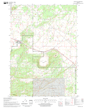
Big Soldier Mountain Quadrangle, Idaho
United States Department of Agriculture Forestry Service topographical map of Big Soldier Mountain, Salmon-Chalis National Forest, Idaho.
Page Size: 21.75 x 27 in (552 x 686 mm)
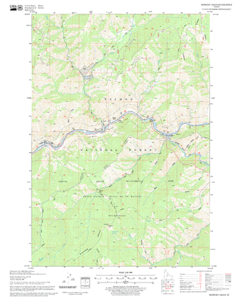
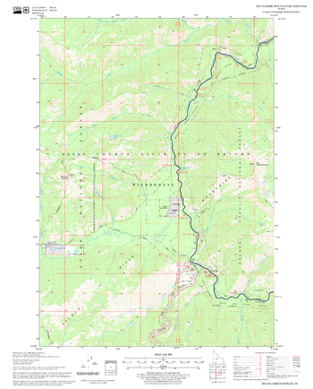
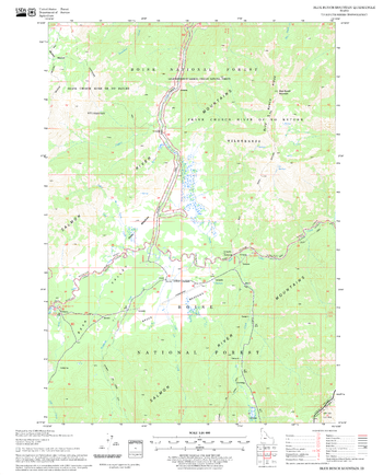
Bighorn Crags Quadrangle, Idaho
United States Department of Agriculture Forestry Service topographical map of Bighorn Crags, Salmon-Chalis National Forest, Idaho.
Page Size: 21.75 x 27 in (552 x 686 mm)
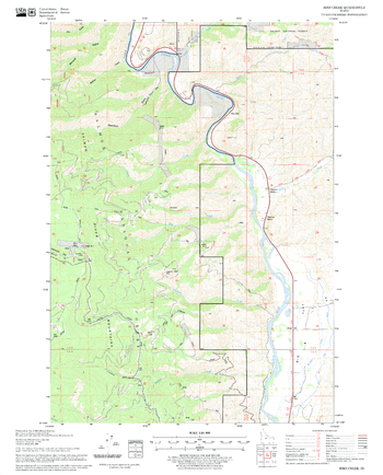
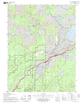
Bird Creek Quadrangle, Idaho
United States Department of Agriculture Forestry Service topographical map of Bird Creek, Salmon-Chalis National Forest, Idaho.
Page Size: 21.75 x 27 in (552 x 686 mm)
Black Butte Quadrangle, Oregon
United States Department of Agriculture Forestry Service topographical map of Black Butte, Deschutes National Forest, Oregon.
Page Size: 21.75 x 27 in (552 x 686 mm)
Black Crater Quadrangle, Oregon
United States Department of Agriculture Forestry Service topographical map of Black Crater, Deschutes National Forest, Oregon.
Page Size: 21.75 x 27 in (552 x 686 mm)
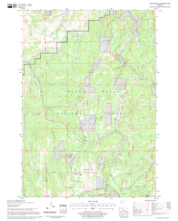
Black Hills Quadrangle, South Dakota
United States Department of Agriculture Forestry Service topographical map of Black Hills, Black Hills National Forest, South Dakota.
Page Size: 21.75 x 27 in (552 x 686 mm)
Black Rock Mountain Quadrangle, California
United States Department of Agriculture Forestry Service topographical map of Black Rock Mountain, Mendocino National Forest, California.
Page Size: 21.75 x 27 in (552 x 686 mm)
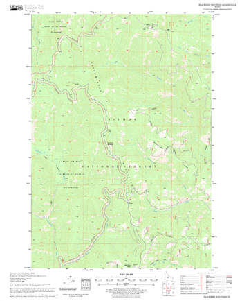
Blackbird Creek Quadrangle, Idaho
United States Department of Agriculture Forestry Service topographical map of Blackbird Creek, Salmon-Chalis National Forest, Idaho.
Page Size: 21.75 x 27 in (552 x 686 mm)
Blackbird Mountain Quadrangle, Idaho
United States Department of Agriculture Forestry Service topographical map of Blackbird Mountain, Salmon-Chalis National Forest, Idaho.
Page Size: 21.75 x 27 in (552 x 686 mm)
Blackhawk Quadrangle, South Dakota
United States Department of Agriculture Forestry Service topographical map of Blackhawk, Black Hills National Forest, South Dakota.
Page Size: 21.75 x 27 in (552 x 686 mm)
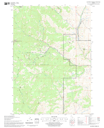
Blowfly Creek Quadrangle, Idaho
United States Department of Agriculture Forestry Service topographical map of Blowfly Creek, Salmon-Chalis National Forest, Idaho.
Page Size: 21.75 x 27 in (552 x 686 mm)
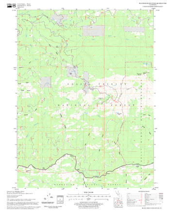
Blue Bunch Mountain Quadrangle, Idaho
United States Department of Agriculture Forestry Service topographical map of Blue Bunch Mountain, Salmon-Chalis National Forest, Idaho.
Page Size: 21.75 x 27 in (552 x 686 mm)
Blue Canyon Quadrangle, California
United States Department of Agriculture Forestry Service topographical map of Blue Canyon, Tahoe National Forest, California.
Page Size: 21.75 x 27 in (552 x 686 mm)