The Times
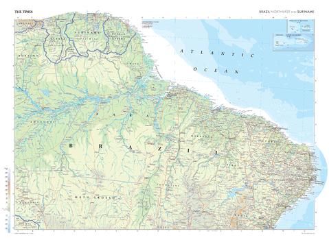
The Times Map of Brazil (Northeast) and Suriname
This map of northeast Brazil and Suriname stands as a benchmark of cartographic excellence, sourced from the industry-leading Times Comprehensive Atlas of the World. Published in full colour, this map offers a comprehensive and updated view of the landscapes that make up this region. Encompassing states such as Pará and Mato Grooso, and with additional mapping coverage of French Guiana and Guyana. Notably, the map also includes inset maps of Fernando de Noronha and Trinade and Martin Vaz Islands. With meticulous attention to detail, this map is an indispensable guide to the geographic intricacies and highlights of Brazil's Northeast and Suriname.
Page Size: 36.5 x 26.75 in (924 x 675 mm)
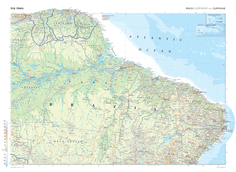
The Times Map of Brazil (Northeast) and Suriname - Compact
This map of northeast Brazil and Suriname stands as a benchmark of cartographic excellence, sourced from the industry-leading Times Comprehensive Atlas of the World. Published in full colour, this map offers a comprehensive and updated view of the landscapes that make up this region. Encompassing states such as Pará and Mato Grooso, and with additional mapping coverage of French Guiana and Guyana. Notably, the map also includes inset maps of Fernando de Noronha and Trinade and Martin Vaz Islands. With meticulous attention to detail, this map is an indispensable guide to the geographic intricacies and highlights of Brazil's Northeast and Suriname.
Page Size: 22.25 x 16.25 in (561 x 410 mm)
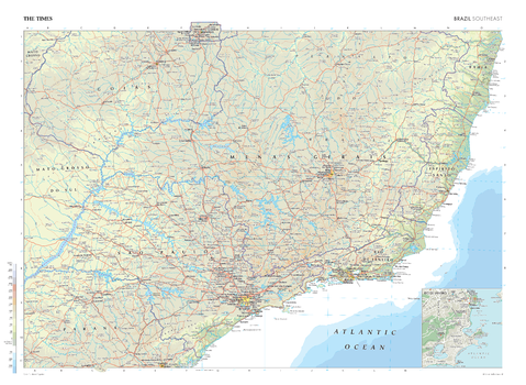
The Times Map of Brazil (Southeast)
This map of Brazil's Southeast region stands as a benchmark of cartographic excellence, sourced from the industry-leading Times Comprehensive Atlas of the World. Published in full colour, this map offers a comprehensive and updated view of the diverse landscapes and attractions that characterise this area. Encompassing states such as São Paulo, Espirito Santo, Minas Gerais and more, this map includes prominent features such as the vibrant cities of Rio de Janeiro, Brasília, São Paulo, . Notably, the map also includes a city plan inset of Rio de Janeiro, offering an extra layer of detail to this coastal city. With meticulous attention to detail, this map is an indispensable guide to the geographic intricacies and highlights of Brazil's Southeast region.
Page Size: 36.5 x 26.75 in (924 x 675 mm)
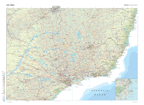
The Times Map of Brazil (Southeast) - Compact
This map of Brazil's Southeast region stands as a benchmark of cartographic excellence, sourced from the industry-leading Times Comprehensive Atlas of the World. Published in full colour, this map offers a comprehensive and updated view of the diverse landscapes and attractions that characterise this area. Encompassing states such as São Paulo, Espirito Santo, Minas Gerais and more, this map includes prominent features such as the vibrant cities of Rio de Janeiro, Brasília, São Paulo, . Notably, the map also includes a city plan inset of Rio de Janeiro, offering an extra layer of detail to this coastal city. With meticulous attention to detail, this map is an indispensable guide to the geographic intricacies and highlights of Brazil's Southeast region.
Page Size: 22.25 x 16.25 in (561 x 410 mm)
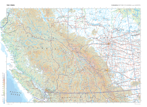
The Times Map of British Columbia and Alberta (Canada)
This map of British Columbia and Alberta (Canada) stands as a benchmark of cartographic excellence, sourced from the industry-leading Times Comprehensive Atlas of the World. Published in full colour, this map offers a comprehensive and updated view of the diverse landscapes that span across these provinces. Prominent features such as the Rocky Mountains and the vibrant cities of Vancouver, Calgary, and Edmonton are clearly identifiable. With meticulous attention to detail, this map is an indispensable guide to the geographic intricacies of British Columbia and Alberta.
Page Size: 36.5 x 26.75 in (924 x 675 mm)
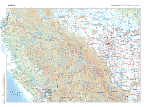
The Times Map of British Columbia and Alberta (Canada) - Compact
This map of British Columbia and Alberta (Canada) stands as a benchmark of cartographic excellence, sourced from the industry-leading Times Comprehensive Atlas of the World. Published in full colour, this map offers a comprehensive and updated view of the diverse landscapes that span across these provinces. Prominent features such as the Rocky Mountains and the vibrant cities of Vancouver, Calgary, and Edmonton are clearly identifiable. With meticulous attention to detail, this map is an indispensable guide to the geographic intricacies of British Columbia and Alberta.
Page Size: 22.25 x 16.25 in (561 x 410 mm)

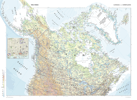
The Times Map of Canada and Greenland
This map of Canada and Greenland is a benchmark of cartographic excellence, taken from the industry leading Times Comprehensive Atlas of the World. Major cities such as Ottawa and Vancouver are easily identifiable, as are the capitals of Toronto and Nuuk. International borders are clearly marked as are provincial and territorial boundaries within Canada. Geographical features, such as the Rocky Mountain range are also shown. Supplementary mapping also shows Iceland in full and the north of the United States. An additional inset map provides a road map of Toronto. Each element is carefully chosen to make the map a coherent and attractive visual guide to Canada and Greenland.
Page Size: 36.5 x 26.75 in (924 x 675 mm)
The Times Map of Canada and Greenland - Compact
This map of Canada and Greenland is a benchmark of cartographic excellence, taken from the industry leading Times Comprehensive Atlas of the World. Major cities such as Ottawa and Vancouver are easily identifiable, as are the capitals of Toronto and Nuuk. International borders are clearly marked as are provincial and territorial boundaries within Canada. Geographical features, such as the Rocky Mountain range are also shown. Supplementary mapping also shows Iceland in full and the north of the United States. An additional inset map provides a road map of Toronto. Each element is carefully chosen to make the map a coherent and attractive visual guide to Canada and Greenland.
Page Size: 22.25 x 16.25 in (561 x 410 mm)
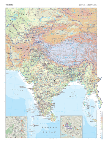
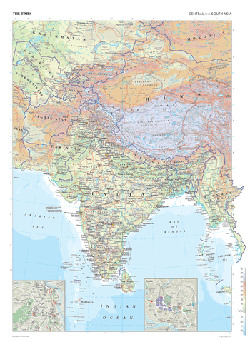
The Times Map of Central and South Asia
This map of Central and South Asia is a benchmark of cartographic excellence, taken from the industry leading Times Comprehensive Atlas of the World. Covering: Afghanistan, Bangladesh, Bhutan, China, India, Kazakhstan, Kyrgyzstan, Myanmar, Nepal, Pakistan, Sri Lanka, Tajikistan, Turkmenistan, and Uzbekistan. capital cities in this region, including Kabul, Islamabad, Delhi, Dhaka, are easily identifiable, as are geographical features such as the Himalayas. Additional inset maps provide detailed road maps of Delhi and Dhaka. Each element is carefully chosen to make the map a coherent and attractive visual guide to Central and South Asia.
Page Size: 26.75 x 36.5 in (675 x 924 mm)
The Times Map of Central and South Asia - Compact
This map of Central and South Asia is a benchmark of cartographic excellence, taken from the industry leading Times Comprehensive Atlas of the World. Covering: Afghanistan, Bangladesh, Bhutan, China, India, Kazakhstan, Kyrgyzstan, Myanmar, Nepal, Pakistan, Sri Lanka, Tajikistan, Turkmenistan, and Uzbekistan. capital cities in this region, including Kabul, Islamabad, Delhi, Dhaka, are easily identifiable, as are geographical features such as the Himalayas. Additional inset maps provide detailed road maps of Delhi and Dhaka. Each element is carefully chosen to make the map a coherent and attractive visual guide to Central and South Asia.
Page Size: 16.25 x 22.25 in (410 x 561 mm)
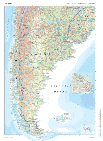
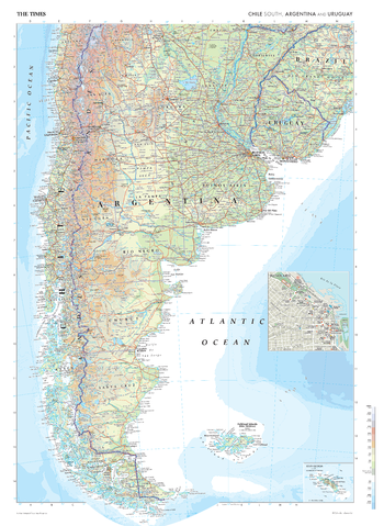
The Times Map of Chile (South), Argentina and Uruguay
This map of Chile's Southern region, Argentina, and Uruguay stands as a benchmark of cartographic excellence, sourced from the industry-leading Times Comprehensive Atlas of the World. Published in full colour, this map offers a comprehensive and updated view of the diverse landscapes and attractions that characterise this area. This plate includes the prominent Andes Mountains, unique Chilean coastal regions, and the Falkland Islands. Notably, the map also includes a city plan inset of Buenos Aires, offering an extra layer of detail to this vibrant capital. With meticulous attention to detail, this map is an indispensable guide to the geographic intricacies and highlights of Chile's Southern region, Argentina, and Uruguay.
Page Size: 26.75 x 36.5 in (675 x 924 mm)
The Times Map of Chile (South), Argentina and Uruguay - Compact
This map of Chile's Southern region, Argentina, and Uruguay stands as a benchmark of cartographic excellence, sourced from the industry-leading Times Comprehensive Atlas of the World. Published in full colour, this map offers a comprehensive and updated view of the diverse landscapes and attractions that characterise this area. This plate includes the prominent Andes Mountains, unique Chilean coastal regions, and the Falkland Islands. Notably, the map also includes a city plan inset of Buenos Aires, offering an extra layer of detail to this vibrant capital. With meticulous attention to detail, this map is an indispensable guide to the geographic intricacies and highlights of Chile's Southern region, Argentina, and Uruguay.
Page Size: 16.25 x 22.25 in (410 x 561 mm)
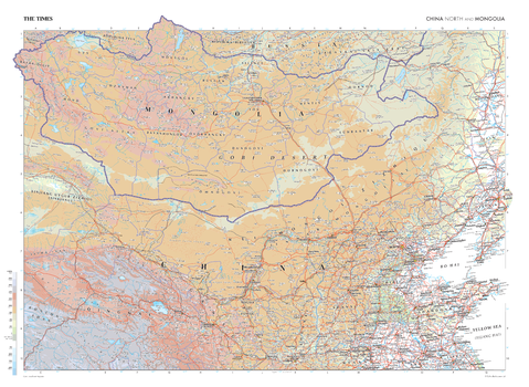
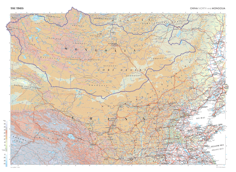
The Times Map of China (North) and Mongolia
This map of Mongolia and China's northern region is a benchmark of cartographic excellence, taken from the industry leading Times Comprehensive Atlas of the World. Presented in full colour, this map provides a comprehensive and updated view of the expansive area spanning across northern China and Mongolia. Prominent geographic features such as the vast Gobi Desert and major cities, including Beijing, are clearly identifiable. Each cartographic element has been thoughtfully selected, creating an informative and visually engaging guide to northern China's and Mongolia.
Page Size: 36.5 x 26.75 in (924 x 675 mm)
The Times Map of China (North) and Mongolia - Compact
This map of Mongolia and China's northern region is a benchmark of cartographic excellence, taken from the industry leading Times Comprehensive Atlas of the World. Presented in full colour, this map provides a comprehensive and updated view of the expansive area spanning across northern China and Mongolia. Prominent geographic features such as the vast Gobi Desert and major cities, including Beijing, are clearly identifiable. Each cartographic element has been thoughtfully selected, creating an informative and visually engaging guide to northern China's and Mongolia.
Page Size: 22.25 x 16.25 in (561 x 410 mm)
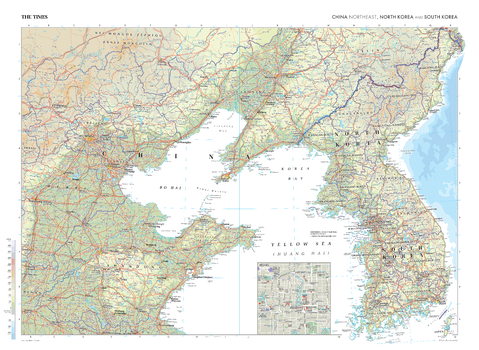
The Times Map of China (North-east), North Korea and South Korea
This map of North Korea, South Korea, and China's north-eastern region is a benchmark of cartographic excellence, taken from the industry leading Times Comprehensive Atlas of the World. Published in full colour, this map offers a comprehensive and updated view of this region's diverse landscape, prominent features such as the Yellow River, and the vibrant cities Seoul and Tianjin, and P'yongyang, are easily identifiable. Notably, the map also includes an inset map of China's capital city: Beijing, adding an extra layer of detail to this dynamic area. With meticulous attention to cartographic detail, this map is an indispensable guide to the geography of North Korea, South Korea, and China's north-eastern region.
Page Size: 36.5 x 26.75 in (924 x 675 mm)

The Times Map of China (North-east), North Korea and South Korea - Compact
This map of North Korea, South Korea, and China's north-eastern region is a benchmark of cartographic excellence, taken from the industry leading Times Comprehensive Atlas of the World. Published in full colour, this map offers a comprehensive and updated view of this region's diverse landscape, prominent features such as the Yellow River, and the vibrant cities Seoul and Tianjin, and P'yongyang, are easily identifiable. Notably, the map also includes an inset map of China's capital city: Beijing, adding an extra layer of detail to this dynamic area. With meticulous attention to cartographic detail, this map is an indispensable guide to the geography of North Korea, South Korea, and China's north-eastern region.
Page Size: 22.25 x 16.25 in (561 x 410 mm)
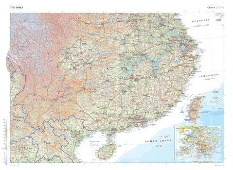
The Times Map of China (South)
This map of China's southern region stands as a benchmark of cartographic excellence, sourced from the industry-leading Times Comprehensive Atlas of the World. Published in full colour, this map offers a comprehensive and updated view of the diverse landscapes that characterise this area. Key cities such as Guangzhou, Shanghai and Chongqing are clearly identifiable. Notably, there is also an inset map showcasing the bustling city of Hong Kong, while additional map coverage includes Taiwan, and the northern regions of Laos, Vietnam and Thailand. With meticulous attention to detail, this map is an indispensable guide to the geographic intricacies of China's southern region.
Page Size: 36.5 x 26.75 in (924 x 675 mm)
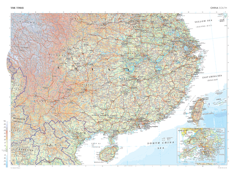
The Times Map of China (South) - Compact
This map of China's southern region stands as a benchmark of cartographic excellence, sourced from the industry-leading Times Comprehensive Atlas of the World. Published in full colour, this map offers a comprehensive and updated view of the diverse landscapes that characterise this area. Key cities such as Guangzhou, Shanghai and Chongqing are clearly identifiable. Notably, there is also an inset map showcasing the bustling city of Hong Kong, while additional map coverage includes Taiwan, and the northern regions of Laos, Vietnam and Thailand. With meticulous attention to detail, this map is an indispensable guide to the geographic intricacies of China's southern region.
Page Size: 22.25 x 16.25 in (561 x 410 mm)
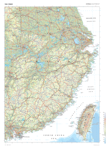
The Times Map of China (Southeast)
This map of China's Southeast regions stands as a benchmark of cartographic excellence, sourced from the industry-leading Times Comprehensive Atlas of the World. Published in full colour, this map offers a comprehensive and updated view of the diverse landscapes that characterise this area. Prominent features such as the island nation of Taiwan and key cities such as Shanghai, Wuhan and Guangzhou are clearly identifiable. With meticulous attention to detail, this map is an indispensable guide to the geographic and urban intricacies of China's Southeast regions.
Page Size: 26.75 x 36.5 in (675 x 924 mm)
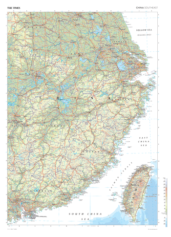
The Times Map of China (Southeast) - Compact
This map of China's Southeast regions stands as a benchmark of cartographic excellence, sourced from the industry-leading Times Comprehensive Atlas of the World. Published in full colour, this map offers a comprehensive and updated view of the diverse landscapes that characterise this area. Prominent features such as the island nation of Taiwan and key cities such as Shanghai, Wuhan and Guangzhou are clearly identifiable. With meticulous attention to detail, this map is an indispensable guide to the geographic and urban intricacies of China's Southeast regions.
Page Size: 16.25 x 22.5 in (410 x 568 mm)