


The Times
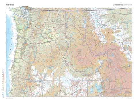
The Times Map of the United States (Northwest) - Compact
This map of the US Northwest stands as a benchmark of cartographic excellence, sourced from the industry-leading Times Comprehensive Atlas of the World. Published in full colour, this map offers a comprehensive and updated view of the landscapes that are found in this region. Encompassing states such as Washington, Montana, Oregon, Idaho, and more, this map includes prominent features such as the Pacific Ocean coastline, Rocky Mountains, and iconic cities including: Seattle, Portland, and Salt Lake City. With meticulous attention to detail, this map is an indispensable guide to the geographic intricacies of the Northwest US.
Page Size: 22.25 x 16.25 in (561 x 410 mm)
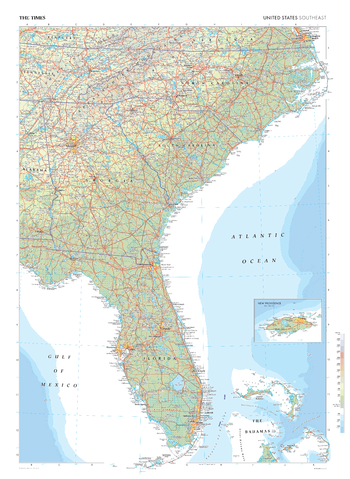
The Times Map of the United States (Southeast)
This map of the US Southeast stands as a benchmark of cartographic excellence, sourced from the industry-leading Times Comprehensive Atlas of the World. Published in full colour, this map offers a comprehensive and updated view of the landscapes that characterise this region. Encompassing states such as Florida, Georgia, North and South Carolina and cities including: Miami, Orlando and Atlanta. Notably, the map includes an inset map of New Providence, adding an extra layer of detail to this island in the Bahamas. With meticulous attention to detail, this map is an indispensable guide to the geographic intricacies of Southeast US.
Page Size: 26.75 x 36.5 in (675 x 924 mm)
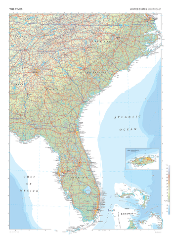
The Times Map of the United States (Southeast) - Compact
This map of the US Southeast stands as a benchmark of cartographic excellence, sourced from the industry-leading Times Comprehensive Atlas of the World. Published in full colour, this map offers a comprehensive and updated view of the landscapes that characterise this region. Encompassing states such as Florida, Georgia, North and South Carolina and cities including: Miami, Orlando and Atlanta. Notably, the map includes an inset map of New Providence, adding an extra layer of detail to this island in the Bahamas. With meticulous attention to detail, this map is an indispensable guide to the geographic intricacies of Southeast US.
Page Size: 16.25 x 22.25 in (410 x 561 mm)
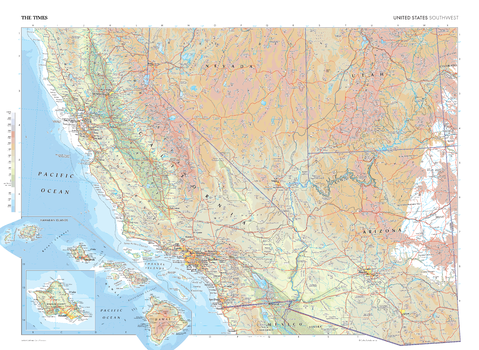
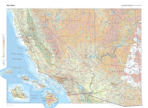
The Times Map of the United States (Southwest)
This map of the US Southwest stands as a benchmark of cartographic excellence, sourced from the industry-leading Times Comprehensive Atlas of the World. Published in full colour, this map offers a comprehensive and updated view of the diverse landscapes that characterise this region. Encompassing states such as California, Arizona, Utah, Nevada, and more, this map includes prominent features such as the Great Basin, the Sierra Nevada mountain range, Central Valley and cities including: Phoenix, Los Angeles and San Francisco. An additional inset map also shows the Hawai'ian Islands adding further detail to this state. With meticulous attention to detail, this map is an indispensable guide to the geographic intricacies of the US Southwest.
Page Size: 36.5 x 26.75 in (924 x 675 mm)
The Times Map of the United States (Southwest) - Compact
This map of the US Southwest stands as a benchmark of cartographic excellence, sourced from the industry-leading Times Comprehensive Atlas of the World. Published in full colour, this map offers a comprehensive and updated view of the diverse landscapes that characterise this region. Encompassing states such as California, Arizona, Utah, Nevada, and more, this map includes prominent features such as the Great Basin, the Sierra Nevada mountain range, Central Valley and cities including: Phoenix, Los Angeles and San Francisco. An additional inset map also shows the Hawai'ian Islands adding further detail to this state. With meticulous attention to detail, this map is an indispensable guide to the geographic intricacies of the US Southwest.
Page Size: 22.25 x 16.25 in (561 x 410 mm)
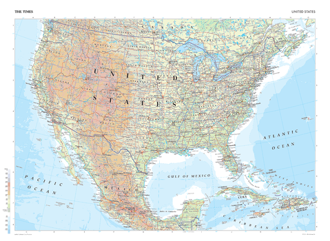
The Times Map of the United States - Compact
This map of the United States is a benchmark of cartographic excellence, taken from the industry leading Times Comprehensive Atlas of the World. There is a high level of detail packed into the map, yet the positioning of every element is carefully chosen to make the map coherent and attractive. Major cities such as New York City, Los Angeles, Chicago and Houston are easily identifiable, as is the capital, Washington D.C. International borders are clearly marked as are state borders. Geographical features including the Rocky Mountain range and major lakes are also shown. Each element is carefully chosen to make the map a coherent and attractive visual guide to the United States.
Page Size: 22.25 x 16.25 in (561 x 410 mm)

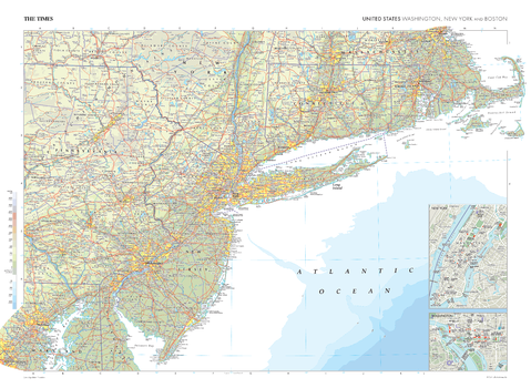
The Times Map of the Washington, New York and Boston (United States)
This map of Washington, New York, and Boston in the US stands as a benchmark of cartographic excellence, sourced from the industry-leading Times Comprehensive Atlas of the World. Published in full colour, this map offers a comprehensive and updated view of states including Pennsylvania, Washington, New York, New Jersey, Connecticut and Massachusetts. This plate also includes prominent features on the US east coast such as the iconic cities of New York City and Washington D.C., both shown with street level detail from inset city plans, the Appalachian Mountains and Long Island Sound. With meticulous attention to detail, this map is an indispensable guide to the geographic intricacies of Washington, New York, and Boston.
Page Size: 36.5 x 26.75 in (924 x 675 mm)
The Times Map of the Washington, New York and Boston (United States) - Compact
This map of Washington, New York, and Boston in the US stands as a benchmark of cartographic excellence, sourced from the industry-leading Times Comprehensive Atlas of the World. Published in full colour, this map offers a comprehensive and updated view of states including Pennsylvania, Washington, New York, New Jersey, Connecticut and Massachusetts. This plate also includes prominent features on the US east coast such as the iconic cities of New York City and Washington D.C., both shown with street level detail from inset city plans, the Appalachian Mountains and Long Island Sound. With meticulous attention to detail, this map is an indispensable guide to the geographic intricacies of Washington, New York, and Boston.
Page Size: 22.25 x 16.25 in (561 x 410 mm)
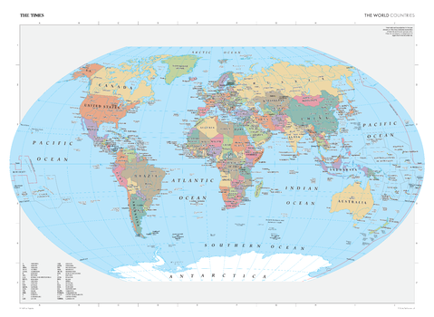
The Times Map of the World (Countries)
This world map has been fully revised and updated to show the most up to date country boundaries. Clearly identifying each country and marking them in contrasting colours, this map is readily accessible to the general reader who needs an up-to-date map to follow reports of world events in newspapers, on radio and on the television. All country names are written in full in English, where space allows, with an additional key provided when initials are used. Capital cities are also clearly marked, as are additional major cities within each country. It is perfect for the home and office.
Page Size: 36.5 x 26.75 in (924 x 675 mm)

The Times Map of the World (Countries) - Compact
This world map has been fully revised and updated to show the most up to date country boundaries. Clearly identifying each country and marking them in contrasting colours, this map is readily accessible to the general reader who needs an up-to-date map to follow reports of world events in newspapers, on radio and on the television. All country names are written in full in English, where space allows, with an additional key provided when initials are used. Capital cities are also clearly marked, as are additional major cities within each country. It is perfect for the home and office.
Page Size: 22.25 x 16.25 in (561 x 410 mm)
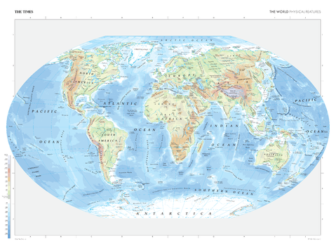
The Times Map of the World (Physical Features)
This map contains all major geographical features of the world including deserts, mountain ranges, oceans, and lakes. Local name forms are used for all towns and cities with the English or historical alternative shown in brackets e.g. Qingzang Gaoyuan (Plateau of Tibet) when needed. Continents are clearly marked, as are seas and oceans. This makes the map readily accessible to the general reader who needs an up-to-date map to follow reports of world events in newspapers, on radio and television. It is perfect for the home and office.
Page Size: 36.5 x 26.75 in (924 x 675 mm)
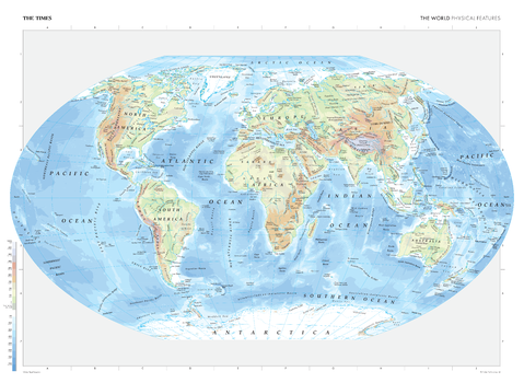
The Times Map of the World (Physical Features) - Compact
This map contains all major geographical features of the world including deserts, mountain ranges, oceans, and lakes. Local name forms are used for all towns and cities with the English or historical alternative shown in brackets e.g. Qingzang Gaoyuan (Plateau of Tibet) when needed. Continents are clearly marked, as are seas and oceans. This makes the map readily accessible to the general reader who needs an up-to-date map to follow reports of world events in newspapers, on radio and television. It is perfect for the home and office.
Page Size: 22.25 x 16.25 in (561 x 410 mm)