


The Times
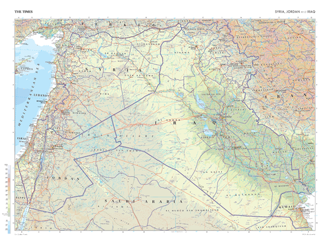
The Times Map of Syria, Jordan and Iraq
This map of Syria, Jordan, and Iraq stands as a benchmark of cartographic excellence, sourced from the industry-leading Times Comprehensive Atlas of the World. Published in full colour, this map offers a comprehensive and updated view of the geography of this region. Prominent features such as the historic cities of Jerusalem and Baghdad, the Mediterranean Coast and the Syrian Desert can all be easily identified. Iran, Saudi Arabia, Kuwait, Israel, and Lebanon also feature. With meticulous attention to detail, this map is an indispensable guide to the geographic intricacies of Syria, Jordan, and Iraq.
Page Size: 36.5 x 26.75 in (924 x 675 mm)

The Times Map of Syria, Jordan and Iraq - Compact
This map of Syria, Jordan, and Iraq stands as a benchmark of cartographic excellence, sourced from the industry-leading Times Comprehensive Atlas of the World. Published in full colour, this map offers a comprehensive and updated view of the geography of this region. Prominent features such as the historic cities of Jerusalem and Baghdad, the Mediterranean Coast and the Syrian Desert can all be easily identified. Iran, Saudi Arabia, Kuwait, Israel, and Lebanon also feature. With meticulous attention to detail, this map is an indispensable guide to the geographic intricacies of Syria, Jordan, and Iraq.
Page Size: 22.25 x 16.25 in (561 x 410 mm)
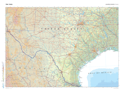
The Times Map of Texas (United States)
This map of Texas stands as a benchmark of cartographic excellence, sourced from the industry-leading Times Comprehensive Atlas of the World. Published in full colour, this map offers a comprehensive and updated view of the diverse landscapes and attractions that characterise this expansive state. Prominent features such as the cities of Houston, Dallas and Austin are clearly identifiable, as is the Mexico/US border. With meticulous attention to detail, this map is an indispensable guide to the geographic intricacies and highlights of Texas.
Page Size: 36.5 x 26.75 in (924 x 675 mm)

The Times Map of Texas (United States) - Compact
This map of Texas stands as a benchmark of cartographic excellence, sourced from the industry-leading Times Comprehensive Atlas of the World. Published in full colour, this map offers a comprehensive and updated view of the diverse landscapes and attractions that characterise this expansive state. Prominent features such as the cities of Houston, Dallas and Austin are clearly identifiable, as is the Mexico/US border. With meticulous attention to detail, this map is an indispensable guide to the geographic intricacies and highlights of Texas.
Page Size: 22.25 x 16.25 in (561 x 410 mm)
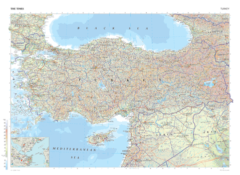
The Times Map of Turkey
This map of Turkey stands as a benchmark of cartographic excellence, sourced from the industry-leading Times Comprehensive Atlas of the World. Published in full colour, this map offers a comprehensive and updated view of the geographical and political landscape of this region. Showing expansive coverage of Turkey, alongside additional views of Cyprus, Syria, Iraq, and Bulgaria. Major cities including Istanbul and the capital, Ankara, are clearly labelled as are surrounding bodies of water, such as the Black Sea and Mediterranean Sea. An additional inset map provides a detailed road map of Istanbul. Each element is carefully chosen to make the map a coherent and attractive visual guide to Turkey.
Page Size: 36.5 x 26.75 in (924 x 675 mm)

The Times Map of Turkey - Compact
This map of Turkey stands as a benchmark of cartographic excellence, sourced from the industry-leading Times Comprehensive Atlas of the World. Published in full colour, this map offers a comprehensive and updated view of the geographical and political landscape of this region. Showing expansive coverage of Turkey, alongside additional views of Cyprus, Syria, Iraq, and Bulgaria. Major cities including Istanbul and the capital, Ankara, are clearly labelled as are surrounding bodies of water, such as the Black Sea and Mediterranean Sea. An additional inset map provides a detailed road map of Istanbul. Each element is carefully chosen to make the map a coherent and attractive visual guide to Turkey.
Page Size: 22.25 x 16.25 in (561 x 410 mm)

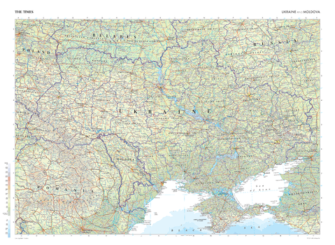
The Times Map of Ukraine and Moldova
This map of Ukraine and Moldova is a benchmark of cartographic excellence, taken from the industry leading Times Comprehensive Atlas of the World. There is a high level of detail packed into the map, yet the positioning of every element is carefully chosen to make the map coherent and attractive. Showing complete maps of Ukraine and Moldova, additional mapping also covers parts of Poland, Belarus, Romania, and Russia. Major cities such as Khakiv and Odesa are clearly identifiable, as are the capitals of Kyiv (Kiev) and Chișinău. Each element is carefully chosen to make the map a coherent and attractive visual guide to Ukraine and Moldova.
Page Size: 36.5 x 26.75 in (924 x 675 mm)
The Times Map of Ukraine and Moldova - Compact
This map of Ukraine and Moldova is a benchmark of cartographic excellence, taken from the industry leading Times Comprehensive Atlas of the World. There is a high level of detail packed into the map, yet the positioning of every element is carefully chosen to make the map coherent and attractive. Showing complete maps of Ukraine and Moldova, additional mapping also covers parts of Poland, Belarus, Romania, and Russia. Major cities such as Khakiv and Odesa are clearly identifiable, as are the capitals of Kyiv (Kiev) and Chișinău. Each element is carefully chosen to make the map a coherent and attractive visual guide to Ukraine and Moldova.
Page Size: 22.25 x 16.25 in (561 x 410 mm)
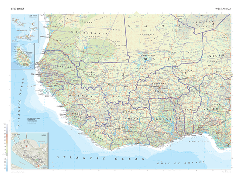
The Times Map of West Africa
This map of West Africa stands as a benchmark of cartographic excellence, sourced from the industry-leading Times Comprehensive Atlas of the World. Published in full colour, this map offers a comprehensive and updated view of the landscapes that are found in this region. Encompassing countries such as Senegal, Benin, Sierra Leone, Burkina Faso, Ghana, Guinea, Liberia and more, this map includes prominent features within the Sahel region, and key landmarks. Notably, the map includes insets of Cape Verde, Santiago, and a Lagos city plan, adding an extra layer of detail to these distinctive areas. With meticulous attention to detail, this map is an indispensable guide to the geographic intricacies of West Africa.
Page Size: 36.5 x 26.75 in (924 x 675 mm)
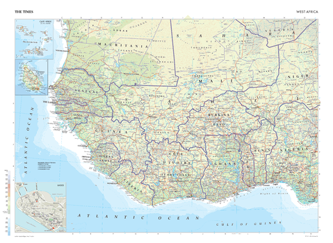
The Times Map of West Africa - Compact
This map of West Africa stands as a benchmark of cartographic excellence, sourced from the industry-leading Times Comprehensive Atlas of the World. Published in full colour, this map offers a comprehensive and updated view of the landscapes that are found in this region. Encompassing countries such as Senegal, Benin, Sierra Leone, Burkina Faso, Ghana, Guinea, Liberia and more, this map includes prominent features within the Sahel region, and key landmarks. Notably, the map includes insets of Cape Verde, Santiago, and a Lagos city plan, adding an extra layer of detail to these distinctive areas. With meticulous attention to detail, this map is an indispensable guide to the geographic intricacies of West Africa.
Page Size: 22.25 x 16.25 in (561 x 410 mm)
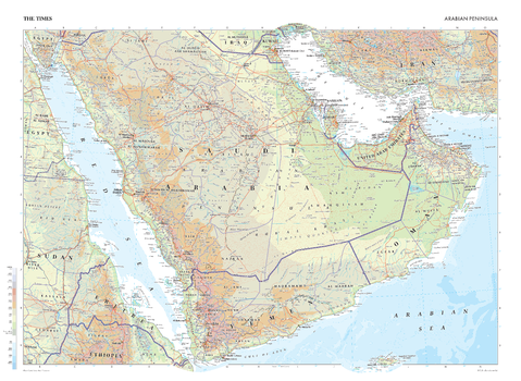
The Times Map of the Arabian Peninsula
This map of the Arabian Peninsula stands as a benchmark of cartographic excellence, sourced from the industry-leading Times Comprehensive Atlas of the World. Published in full colour, this map offers a comprehensive and updated view of this region; with coverage of Saudi Arabia, Yemen, Oman, the United Arab Emirates, Eritrea and Qatar. Prominent features such as vast deserts, the Suez Canal and key cities such as Riyadh and Dubai are clearly identifiable. With meticulous attention to detail, this map is an indispensable guide to the geographic intricacies of the Arabian Peninsula.
Page Size: 36.5 x 26.75 in (924 x 675 mm)
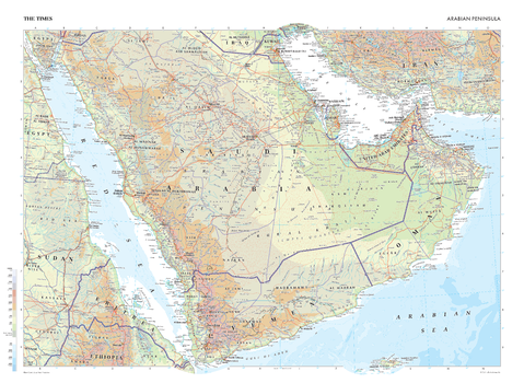
The Times Map of the Arabian Peninsula - Compact
This map of the Arabian Peninsula stands as a benchmark of cartographic excellence, sourced from the industry-leading Times Comprehensive Atlas of the World. Published in full colour, this map offers a comprehensive and updated view of this region; with coverage of Saudi Arabia, Yemen, Oman, the United Arab Emirates, Eritrea and Qatar. Prominent features such as vast deserts, the Suez Canal and key cities such as Riyadh and Dubai are clearly identifiable. With meticulous attention to detail, this map is an indispensable guide to the geographic intricacies of the Arabian Peninsula.
Page Size: 22.25 x 16.25 in (561 x 410 mm)
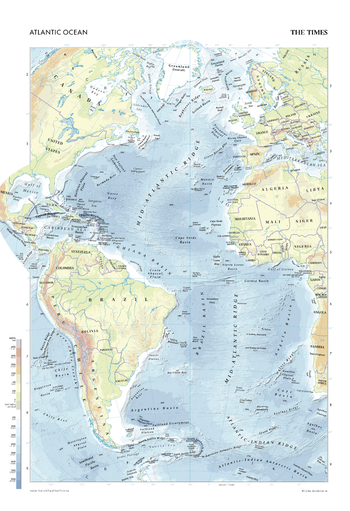
The Times Map of the Atlantic Ocean
This map of the Atlantic Ocean stands as a benchmark of cartographic excellence, sourced from the industry-leading Times Comprehensive Atlas of the World. Published in full colour, this map offers a comprehensive and updated view of the diverse seascapes and features that define this vast ocean. Encompassing the waters between the continents of North and South America, Europe, and Africa, this map displays the islands, ridges, basins and plateaus under the Atlantic Ocean. With meticulous attention to detail, this map is an indispensable guide to the geographic intricacies and highlights of the Atlantic Ocean.
Page Size: 18.25 x 26.75 in (462 x 675 mm)
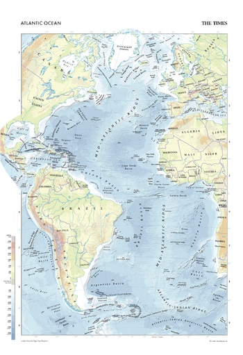
The Times Map of the Atlantic Ocean - Compact
This map of the Atlantic Ocean stands as a benchmark of cartographic excellence, sourced from the industry-leading Times Comprehensive Atlas of the World. Published in full colour, this map offers a comprehensive and updated view of the diverse seascapes and features that define this vast ocean. Encompassing the waters between the continents of North and South America, Europe, and Africa, this map displays the islands, ridges, basins and plateaus under the Atlantic Ocean. With meticulous attention to detail, this map is an indispensable guide to the geographic intricacies and highlights of the Atlantic Ocean.
Page Size: 11.25 x 16.25 in (281 x 410 mm)
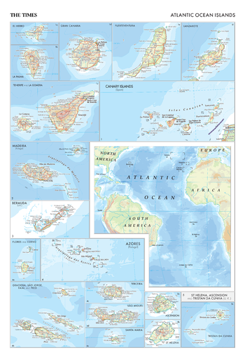
The Times Map of the Atlantic Ocean Islands
This map of Atlantic Ocean islands stands as a benchmark of cartographic excellence, sourced from the industry-leading Times Comprehensive Atlas of the World. Published in full colour, this plate offers a comprehensive and updated view of the diverse islands that dot the Atlantic Ocean, including: Madeira, Bermuda, . Encompassing islands in situ within the ocean, as well as providing more than 15 detailed insets of key islands, this map provides a clear representation of the distribution and features of these islands. With meticulous attention to detail, this map is an indispensable guide to the geographic intricacies and highlights of the Atlantic Ocean islands.
Page Size: 18.25 x 26.75 in (462 x 675 mm)
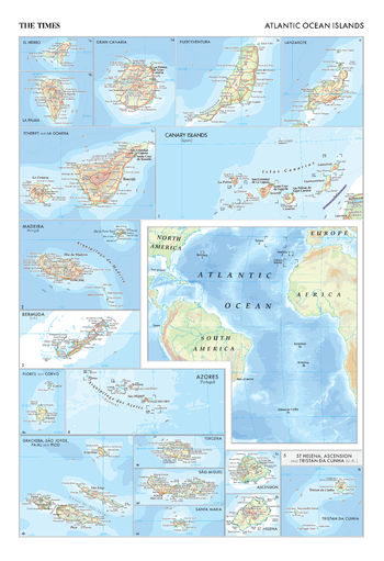
The Times Map of the Atlantic Ocean Islands - Compact
This map of Atlantic Ocean islands stands as a benchmark of cartographic excellence, sourced from the industry-leading Times Comprehensive Atlas of the World. Published in full colour, this plate offers a comprehensive and updated view of the diverse islands that dot the Atlantic Ocean, including: Madeira, Bermuda, . Encompassing islands in situ within the ocean, as well as providing more than 15 detailed insets of key islands, this map provides a clear representation of the distribution and features of these islands. With meticulous attention to detail, this map is an indispensable guide to the geographic intricacies and highlights of the Atlantic Ocean islands.
Page Size: 11.25 x 16.25 in (281 x 410 mm)
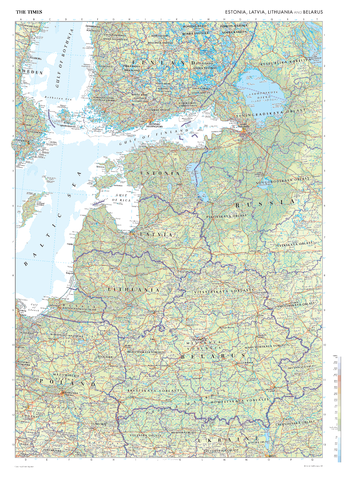
The Times Map of the Baltic States
This map of the Baltic States, encompassing Estonia, Latvia, Lithuania, and Belarus, stands as a benchmark of cartographic excellence, sourced from the industry-leading Times Comprehensive Atlas of the World. Published in full colour, this map offers a comprehensive and updated view of the landscapes included in this region. Prominent features such as the Baltic coastlines, historic cities such as Warszawa and Riga, and key landmarks are clearly identifiable. With meticulous attention to detail, this map is an indispensable guide to the geographic intricacies of the Baltic States.
Page Size: 26.75 x 36.5 in (675 x 924 mm)

The Times Map of the Baltic States - Compact
This map of the Baltic States, encompassing Estonia, Latvia, Lithuania, and Belarus, stands as a benchmark of cartographic excellence, sourced from the industry-leading Times Comprehensive Atlas of the World. Published in full colour, this map offers a comprehensive and updated view of the landscapes included in this region. Prominent features such as the Baltic coastlines, historic cities such as Warszawa and Riga, and key landmarks are clearly identifiable. With meticulous attention to detail, this map is an indispensable guide to the geographic intricacies of the Baltic States.
Page Size: 16.25 x 22.25 in (410 x 561 mm)
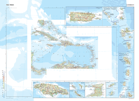
The Times Map of the Caribbean
This map of the Caribbean stands as a benchmark of cartographic excellence, sourced from the industry-leading Times Comprehensive Atlas of the World. Published in full colour, this map offers a comprehensive and updated view of the numerous islands that make up this area in situ. There are a further twelve inset maps of key islands, including: Jamaica, Trinidad, Grenada, Puerto Rico, and Barbados. With meticulous attention to detail, this map is an indispensable guide to the geographic intricacies and highlights of the Caribbean.
Page Size: 36.5 x 26.75 in (924 x 675 mm)
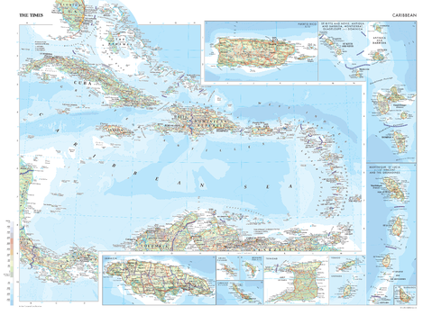
The Times Map of the Caribbean - Compact
This map of the Caribbean stands as a benchmark of cartographic excellence, sourced from the industry-leading Times Comprehensive Atlas of the World. Published in full colour, this map offers a comprehensive and updated view of the numerous islands that make up this area in situ. There are a further twelve inset maps of key islands, including: Jamaica, Trinidad, Grenada, Puerto Rico, and Barbados. With meticulous attention to detail, this map is an indispensable guide to the geographic intricacies and highlights of the Caribbean.
Page Size: 22.25 x 16.25 in (561 x 410 mm)