Stanfords
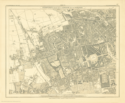
Stanford's Library Map of London Sheet 6 Black and White (1862)
The Stanford’s Library Map of London (Sheet 6) is from a fascinating series of reproductions from our Edward Stanford Cartographic Collection archive.
Page Size: 14.75 x 17.75 in (370 x 450 mm)
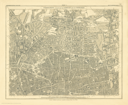
Stanford's Library Map of London Sheet 7 Black and White (1862)
The Stanford’s Library Map of London (Sheet 7) is from a fascinating series of reproductions from our Edward Stanford Cartographic Collection archive.
Page Size: 14.75 x 17.75 in (370 x 450 mm)
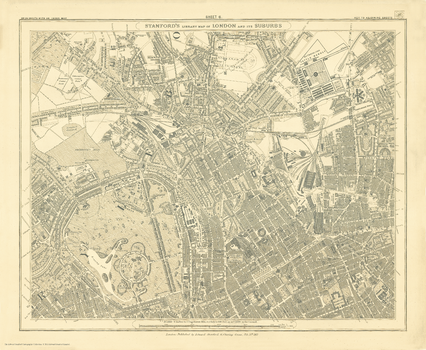
Stanford's Library Map of London Sheet 8 Black and White (1862)
The Stanford’s Library Map of London (Sheet 8) is from a fascinating series of reproductions from our Edward Stanford Cartographic Collection archive.
Page Size: 14.75 x 17.75 in (370 x 450 mm)
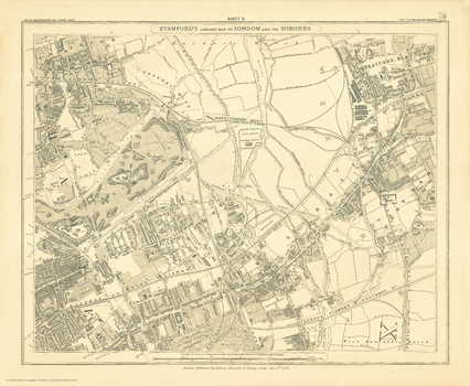
Stanford's Library Map of London Sheet 9 Black and White (1862)
The Stanford’s Library Map of London (Sheet 9) is from a fascinating series of reproductions from our Edward Stanford Cartographic Collection archive.
Page Size: 14.75 x 17.75 in (370 x 450 mm)
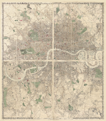
Stanford's Library Map of London and its Suburbs (1878)
The Stanford’s Library Map of London and its Suburbs is from a fascinating series of reproductions from our Edward Stanford Cartographic Collection archive.
Page Size: 68 x 77.75 in (1725 x 1970 mm)
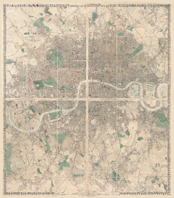
Stanford's Library Map of London and its Suburbs (1878) - Resized to 2A0 width
Resized so that the short side is equivalent to 2A0 short side. The Stanford’s Library Map of London and its Suburbs is from a fascinating series of reproductions from our Edward Stanford Cartographic Collection archive.
Page Size: 47 x 53.5 in (1189 x 1358 mm)
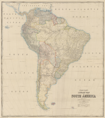
Stanford's Library Map of South America (1864)
The Stanford’s Map of South America is from a fascinating series of reproductions from our Edward Stanford Cartographic Collection archive. This reproduction of a map published in 1879 by the founder of our company, Edward Stanford. It was constructed in 1864 by Alexander Keith Johnston who was a geographer in Edinburgh for the Queen. The continent is shown already in its port-colonial stage but with many international borders not yet fixed and different from today’s. An interesting feature of the map is the presentation of several disputed regions, between Bolivia and Paraguay, Peru and Ecuador, or Brazil and the “Granadian Confederation” (present day Colombia). When this map was made, Guyana was British Guiana and Suriname was Dutch Guiana. Central America is also shown in slightly less detail up to the Southern part of Guatemala and some of the Caribbean islands are included up to the southern tip of Dominica. Topography is indicated by hachures and many tributaries of the Amazon, the Orinoco and the Parana are named. Latitude and longitude lines are drawn at 5° intervals. This reproduction has been taken from an original cartographic scale of 1:5,275,000 on a 31x28” map that was made out of four sheets.
Page Size: 40 x 45.25 in (1015 x 1146 mm)
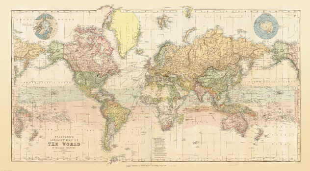
Stanford's Library Map of the World (1879)
This reproduction of a beautiful wall map of the world published by Edward Stanford in 1879 shows the zones of trade winds which for centuries determined the routes taken across the oceans by ships like the Cutty Sark and other clippers. Presented in lovely pastel colours, the map offers a great deal of interesting information both on land and sea. Across the oceans in addition to the zones of trade winds it also shows the regions of calms and monsoons, the direction of currents, principal “Ocean Mail” routes annotated with distances, and submarine telegraph cables. On land countries are shown in different colours, with their borders emphasized by stronger tints. Given the date of the map’s publication, much of Africa is still not colonized and Europe too is very different from today. In terms of typography, main mountain ranges are shown by hachures and the map has a surprisingly large number of place names. Eastern Siberia with Alaska and New Zealand with most of the South Pacific are shown on both sides of the map for more convenient presentation of that part of the world. Two insets show the Polar region, with much of the coast of the Antarctic still to be properly mapped. Latitude and longitude lines are at 10° intervals; the map is drawn on a Mercator projection. Additional features include time difference from the Greenwich Meridian and a calendar showing the progress of the sun within the Tropics.
Page Size: 38.5 x 69.5 in (976 x 1762 mm)
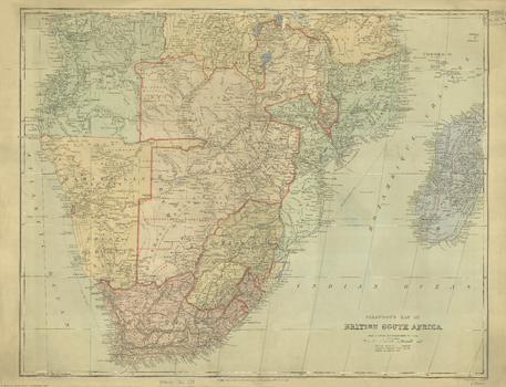
Stanford's Map of British South Africa (1894)
The Stanford’s Map of British South Africa is from a fascinating series of reproductions from our Edward Stanford Cartographic Collection archive.
Page Size: 22.25 x 29 in (562 x 734 mm)
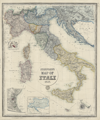
Stanford's Map of Italy (1859)
The Stanford’s Map of Italy is from a fascinating series of reproductions from our Edward Stanford Cartographic Collection archive. This is a reproduction of a map originally published on 2nd May 1859 by Edward Stanford, the founder of our company. The map catches the country in an interesting stage of its history, just before the unification, and still shows the individual states: the Kingdom of Piedmont - Sardinia, the Grand Duchy of Tuscany, the Kingdom of the Two Sicilies, the Papal States, etc, all in different colours. Hachures are used to show the spine of the Apennines and other mountainous regions. Interesting insets show enlargements of the environs of Venice, Genoa and Naples with Vesuvius, and another panel presents the whole of the Austro-Hungarian Empire which then still included Lombardy and north-eastern Italy. This reproduction was taken from what used to be called a “cloth-dissected” map, made when the map itself was cut into sections and each section then individually pasted onto an overall cloth backing for the whole map. In this version the whole map is backed onto cloth in one piece but the gaps between the sections have been reproduced in the printing to preserve the style and the feeling of the original. This lovely map will appeal to anyone interested in this great country.
Page Size: 26.25 x 31.5 in (662 x 796 mm)
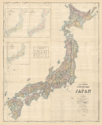
Stanford's Map of Japan (1879)
The Stanford’s Library Map of Japan is from a fascinating series of reproductions from our Edward Stanford Cartographic Collection archive.
Page Size: 53.75 x 66.5 in (1365 x 1685 mm)
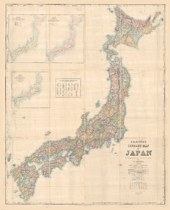
Stanford's Map of Japan (1879) - Resized to 2A0 width
Resized so that the short side is equivalent to 2A0 short side. The Stanford’s Library Map of Japan is from a fascinating series of reproductions from our Edward Stanford Cartographic Collection archive.
Page Size: 47 x 58 in (1189 x 1468 mm)
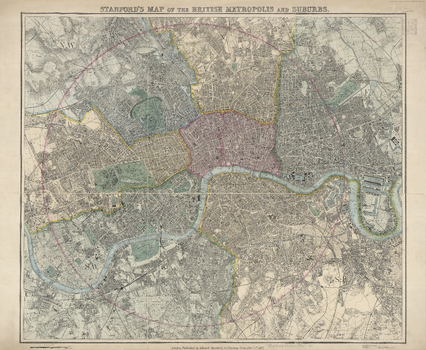
Stanford's Map of the British Metropolis (1877)
The Stanford's Map of the British Metropolis is from a fascinating series of reproductions from our Edward Stanford Cartographic Collection archive.
Page Size: 27.5 x 33.5 in (696 x 848 mm)
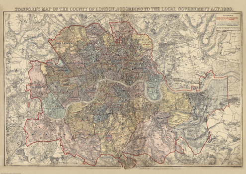
Stanford's Map of the County of London (1888)
This map is from a fascinating series of reproductions from our Edward Stanford Cartographic Collection archive. The Stanford’s Map of the County of London, According to the Local Government Act 1888, to give it its full title, presenting the administrative division of the capital and indicating the boundaries of both the Electoral Divisions returning two members to the County Council and of the Urban Sanitary Districts with control of main roads under the Highways and Locomotives (Amendment) Act of 1878. The colouring and the boundaries are overlaid on a street plan with names of main and selected smaller streets, graphics indicating parks and other common land, railway lines, etc. Hachures show the topography with the hills of north and south London clearly marked. This is London which, administratively, extends north of the Thames between Hammersmith, Hampstead, Stamford Hill and Poplar, and south of the river between Putney, Streatham, Lower Sydenham and Eltham (although the map itself extends a bit further out, particularly in the north-east). An interesting feature is the inclusion within the County of London of a small area outside its overall boundary – the site of the present day Leg of Mutton Nature Reserve in Barnes.
Page Size: 28 x 39.5 in (707 x 1000 mm)
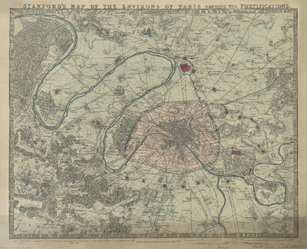
Stanford's Map of the Environs of Paris (1870)
The Stanford’s Map of the environs of Paris is from a fascinating series of reproductions from our Edward Stanford Cartographic Collection archive. The text reads ‘Stanford’s map of the environs of Paris shewing the fortifications.’ It is dated September 1st 1870 (nineteen years before the Eiffel Tower was erected). The map covers the centre of Paris (indicated in pink) and extends well outside the present day Boulevard Périphérique, the course of which is indicated on the map by the old city walls. Coverage of the north includes St Danis up to Montmorency. The East includes the Château de Vincennes, most of Champigny-sur-Marne to the north-eastern Bondy. Coverage of the south shows Villejuif down to Forêt Domaniale de Verrières. In the west the map takes us beyond the northward bend in the Seine to include all of the Bois de Boulogne, the Parc de St. Cloud all the way up to St-Germain-en-Laye. This reproduction has been taken from the original cartographic scale of [1:60,000] on an 18.5”x23” map. Various districts of the city, as well as surrounding villages are named. No street names are shown. The map has no legend but topographic artistry shows elevated areas and other details. This lovely map will appeal to anyone interested in this great city.
Page Size: 20 x 24.5 in (502 x 620 mm)
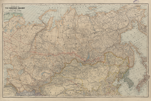
Stanford's Map of the Siberian Railway (1904)
The Stanford’s Map of the Siberian Railway is from a fascinating series of reproductions from our Edward Stanford Cartographic Collection archive. Depicting the great land route to China and Korea, this map was published by Edward Stanford, Long Acre on the 1st February 1904. This vital rail route was also known as the Moscow Highway or the Tea Route because of the large quantities of tea exported from China. It connected European Russia to Siberia and China. Construction started in 1730 and was not completed until the mid 19th-century. Until the Tran-Siberian Railway was built in 1916, the Siberian Railway route was the longest and most famous. This is a beautifully detailed map that will appeal to anyone with an interest in railway history.
Page Size: 30 x 45 in (760 x 1140 mm)
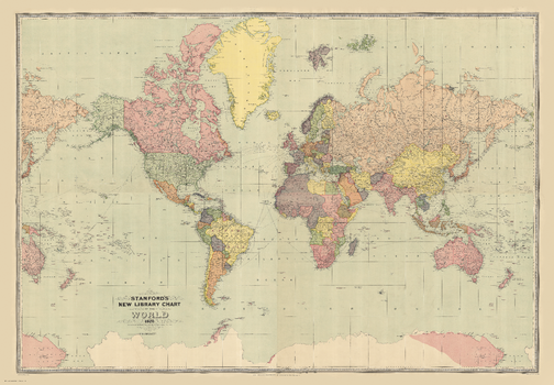
Stanford's New Library Chart of the World (1920)
The Stanford’s New Library Chart of the World is from a fascinating series of reproductions from our Edward Stanford Cartographic Collection archive. This map was published by Stanfords in January 1920 and says ‘drawn to an equatorial scale of 350 nautical miles to 1 inch'. Displays submarine telegraph cables. Published just after World War I the boundaries are as per the Treaty of Versailles. The British Empire, at its height, is shown in dark pink. This is a very interesting map for anyone with an interest in history as it shows the world as it was in the 1920s from a British cartographer’s viewpoint.
Page Size: 52 x 75 in (1321 x 1902 mm)
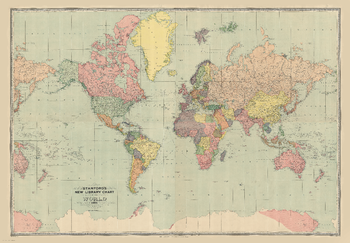
Stanford's New Library Chart of the World (1920) - Resized to 2A0 height
Resized so that the short side is equivalent to 2A0 short side. The Stanford’s New Library Chart of the World is from a fascinating series of reproductions from our Edward Stanford Cartographic Collection archive. This map was published by Stanfords in January 1920 and says ‘drawn to an equatorial scale of 350 nautical miles to 1 inch'. Displays submarine telegraph cables. Published just after World War I the boundaries are as per the Treaty of Versailles. The British Empire, at its height, is shown in dark pink. This is a very interesting map for anyone with an interest in history as it shows the world as it was in the 1920s from a British cartographer’s viewpoint.
Page Size: 47 x 67.5 in (1189 x 1712 mm)
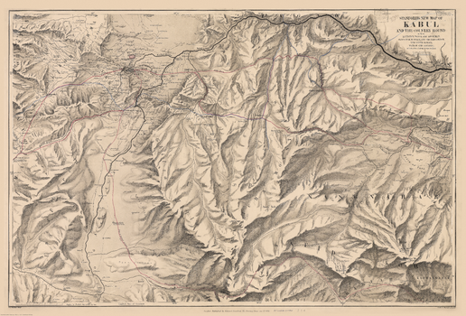
Stanford's New Map of Kabul (1880)
The Stanford’s New Map of Kabul is from a fascinating series of reproductions from our Edward Stanford Cartographic Collection archive. This map was published by Stanfords in January 1880 and says ‘Stanford’s New Map of Kabul and the country round as far as Kohistan, Tagao, and Lughman: Gandamak, Kurram, and Shutargardan; The Upper Logar; Maidan and Argandi; with the sites of all the recent conflicts.’ The whole map is tonal except for a few red and blue lines. One of which indicates the route of Lieutenant Vincent Eyre and the other captives. Another shows General Roberts’ advance. This is a beautiful historic map with lots of regions fascinatingly still marked as ‘unexplored’.
Page Size: 27 x 40 in (685 x 1010 mm)
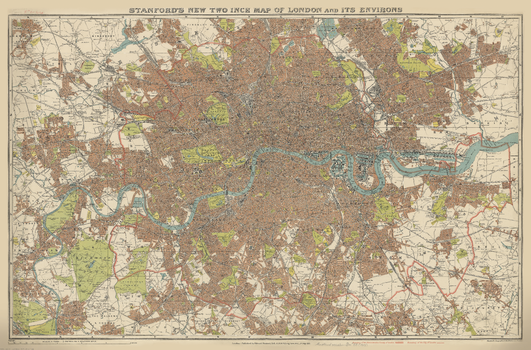
Stanford's New Two Inch Map of London (1913)
The Stanford’s New Two Inch Map of London is from a fascinating series of reproductions from our Edward Stanford Cartographic Collection archive.
Page Size: 28.75 x 43.5 in (725 x 1100 mm)