National Geographic
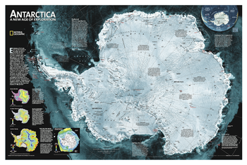
Antarctica Satellite
A striking view of Antarctica's terrain, compiled from 4,500 satellite scans. Additional inset maps show surface elevation, ice sheet thickness, velocity of ice flow, and sea ice movement and windflow.
Page Size: 33 x 22 in (834 x 555 mm)
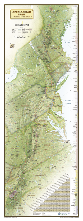
Appalachian Trail Wall Map
National Geographic's wall map of the Appalachian Trail is ideal for fans and hikers of this magnificent national scenic trail.
Developed in cooperation with the Appalachian Trail Conservancy, this beautiful poster, measuring 48" x 18", shows the entire length of the trail from Maine to Georgia. A unique elevation profiles highlight the trail's peaks and valleys and an informative mileage chart shows the distance between key locations. Also highlighted on the map are National Forests, National Park Service lands, State Forests and Parks, and major highways and interstates. Points of interest include Appalachian Trail information centers and shelters.
Net proceeds from the sale of this map support National Geographic's vital exploration, conservation, research, and education programs.
Page Size: 18 x 48 in (457 x 1219 mm)
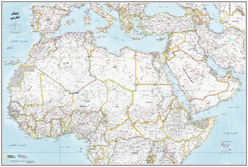
Arab World Map - in Arabic
National Geographic, in association with the Qatar Foundation International, have teamed up to create this Arab World Map. This 2019 map utilizes National Geographic’s exacting cartographic standards and marries them with the Qatar Foundation International’s commitment to Arabic languages, producing a unique and definitive map of the region.
What makes this map unique is that the text is all in Arabic.
The area mapped includes north Africa and southern Europe and stretches south to the Equator. It includes the whole of Turkey, Saudi Arabia and east to Iran.
At a scale of 1:9,500,00 the map is a perfect reference for Arabic speakers and helps bring context to the region. Areas in dispute are noted, and their defacto status and borders are shown.
Page Size: 37.75 x 25.5 in (959 x 648 mm)
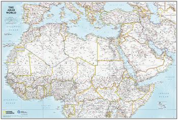
Arab World Map - in English
National Geographic, in association with the Qatar Foundation International, have teamed up to create this Arab World Map. This 2019 map utilizes National Geographic’s exacting cartographic standards and marries them with the Qatar Foundation International’s commitment to Arabic languages, producing a unique and definitive map of the region.
The area mapped includes north Africa and southern Europe and stretches south to the Equator. It includes the whole of Turkey, Saudi Arabia and east to Iran.
At a scale of 1:9,500,00 the map perfect for reference and helps bring context to the region. Areas in dispute are noted, and their defacto status and borders are shown.
Page Size: 37.75 x 25.5 in (959 x 648 mm)
Arabian Peninsula - Atlas of the World, 10th Edition
Bahrain, Kuwait, Oman, Qatar, Saudi Arabia, United Arab Emirates, Yemen
Page Size: 28 x 22 in (711 x 559 mm)
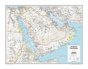
Arabian Peninsula - Atlas of the World, 11th Edition
This Arabian Peninsula map of physical and political features can fit in any space. Showcasing the region in stunning detail with state-of-the-art cartographic techniques delivering accuracy and exceptional quality, the innovative and engaging design makes the content easily accessible and user-friendly.
Ideal for classrooms with an emphasis on teaching geography or environmental themes. The inclusion of physical features gives your students a genuine feel for how our world appears.
This map uses a bright, easy to read color palette featuring blue oceans and stunning shaded relief that has been featured on National Geographic wall maps for over 75 years. It is drawn in the Transverse Mercator projection, which is a cylindrical map projection for nautical navigation because it represents lines of constant course.
This map is found in National Geographic's 11th Edition World Atlas and is now available as a stand alone product.
Page Size: 31.5 x 24 in (798 x 610 mm)

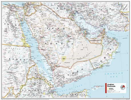
Arabian Peninsula - Atlas of the World, 11th Edition - Compact
This Arabian Peninsula map of physical and political features can fit in any space. Showcasing the region in stunning detail with state-of-the-art cartographic techniques delivering accuracy and exceptional quality, the innovative and engaging design makes the content easily accessible and user-friendly.
Ideal for classrooms with an emphasis on teaching geography or environmental themes. The inclusion of physical features gives your students a genuine feel for how our world appears.
This map uses a bright, easy to read color palette featuring blue oceans and stunning shaded relief that has been featured on National Geographic wall maps for over 75 years. It is drawn in the Transverse Mercator projection, which is a cylindrical map projection for nautical navigation because it represents lines of constant course.
This map is found in National Geographic's 11th Edition World Atlas and is now available as a stand alone product.
Page Size: 21.5 x 16.25 in (540 x 413 mm)
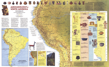
Archaeology of South America - Published 1982
Explore the fascinating world of the Inca and other South American civilizations with this informative "Archaeology of South America" map. Published in March 1982 with the "Indians of South America" map, this work is filled with illustrations and information about pre-Columbian artifacts and archeological sites including Cuzco and Machu Picchu.
Page Size: 37 x 22.75 in (938 x 573 mm)
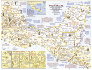
Archeological of Middle America - Published 1968
Take an archeaological adventure through the "Land of the Feathered Serpent." This educational map of Middle America features an abundance of information on the region's intriguing civilizations and the temples, pyramids, and ruins they left behind. Published in October 1968.
Page Size: 25 x 19 in (632 x 480 mm)
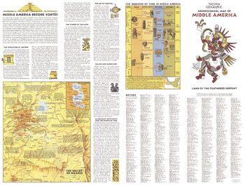
Archeological of Middle America Theme - Published 1968
Half of a two-map set published in October 1968, this Archeological Map of Middle America features a wealth of information on the Aztec and Maya civilizations that inhabited the region before the arrival of Cortes. This map includes an index for side one of the two-map set.
Page Size: 25 x 19 in (632 x 480 mm)
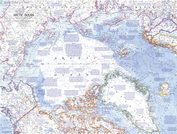
Arctic Ocean - Published 1971
This detailed map of the Arctic Ocean contains a wealth of historical notes, including expedition routes. Published in October 1971 to accompany the "Arctic Ocean Floor" map. Similar in style to ocean maps of the Atlantic (1968) and Pacific (1969).
Page Size: 24.25 x 18.5 in (613 x 467 mm)
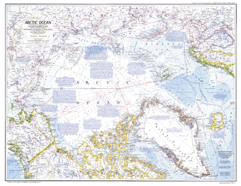
Arctic Ocean - Published 1983
An attractive and informative map of the dramatic and remote Arctic Ocean. Of particular interest is the abundance of historical and geographical notes. Published in February 1983 as a companion to the "Peoples of the Arctic" map and four articles, including "Hunters of the Lost Spirit."
Page Size: 29.5 x 22.75 in (748 x 577 mm)
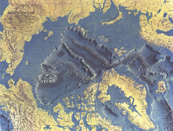
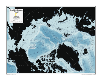
Arctic Ocean Floor - Published 1971
This distinctive physical map of the Arctic Ocean floor provides stunning details of submarine terrain such as continental shelves, abyssal plains, ridges, and fracture zones. Published in October 1971 to accompany the "Arctic Ocean" map.
Page Size: 24.25 x 18.5 in (613 x 467 mm)
Arctic Ocean Floor - Atlas of the World, 10th Edition
null
Page Size: 28 x 22 in (711 x 559 mm)

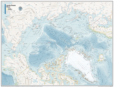
Arctic Ocean Floor - Atlas of the World, 11th Edition
This map of physical features can fit in any space. Showcasing the Arctic Ocean floor in stunning detail with state-of-the-art cartographic techniques delivering accuracy and exceptional quality, the innovative and engaging design makes the content easily accessible and user-friendly.
Ideal for classrooms with an emphasis on teaching geography or environmental themes. The mapping of the ocean terrain gives your students a unique glimpse into how our world appears under the sea.
This physical map of the Arctic Ocean floor uses stunning contrasts to highlight the ocean floor and its physical features. Drawn in the Azimuthal Equidistant projection, this map ensures that all points on the map are at proportionally correct distances from the center point, in this case, the North Pole.
This map is found in National Geographic's 11th Edition World Atlas and is now available as a stand alone product.
Page Size: 31.5 x 24 in (798 x 610 mm)
Arctic Ocean Floor - Atlas of the World, 11th Edition - Compact
This map of physical features can fit in any space. Showcasing the Arctic Ocean floor in stunning detail with state-of-the-art cartographic techniques delivering accuracy and exceptional quality, the innovative and engaging design makes the content easily accessible and user-friendly.
Ideal for classrooms with an emphasis on teaching geography or environmental themes. The mapping of the ocean terrain gives your students a unique glimpse into how our world appears under the sea.
This physical map of the Arctic Ocean floor uses stunning contrasts to highlight the ocean floor and its physical features. Drawn in the Azimuthal Equidistant projection, this map ensures that all points on the map are at proportionally correct distances from the center point, in this case, the North Pole.
This map is found in National Geographic's 11th Edition World Atlas and is now available as a stand alone product.
Page Size: 21.5 x 16.25 in (540 x 413 mm)
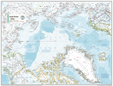
Arctic Ocean Political - Atlas of the World, 11th Edition
This map of political features can fit in any space. Showcasing the Arctic Ocean in stunning detail with state-of-the-art cartographic techniques delivering accuracy and exceptional quality, the innovative and engaging design makes the content easily accessible and user-friendly.
Ideal for classrooms with an emphasis on teaching geography or environmental themes. The inclusion of physical features on this map gives your students a genuine feel for how the African continent appears.
This political map of the Arctic Ocean uses a bright, easy to read color palette featuring blue oceans and stunning shaded relief that has been featured on National Geographic wall maps for over 75 years.
Names of geographic features such as international boundaries, cities, rivers and lakes are carefully placed on the map to maintain legibility.
This map is found in National Geographic's 11th Edition World Atlas and is now available as a stand alone product.
Page Size: 31.5 x 24 in (798 x 610 mm)

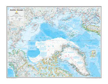
Arctic Ocean Political - Atlas of the World, 11th Edition - Compact
This map of political features can fit in any space. Showcasing the Arctic Ocean in stunning detail with state-of-the-art cartographic techniques delivering accuracy and exceptional quality, the innovative and engaging design makes the content easily accessible and user-friendly.
Ideal for classrooms with an emphasis on teaching geography or environmental themes. The inclusion of physical features on this map gives your students a genuine feel for how the African continent appears.
This political map of the Arctic Ocean uses a bright, easy to read color palette featuring blue oceans and stunning shaded relief that has been featured on National Geographic wall maps for over 75 years.
Names of geographic features such as international boundaries, cities, rivers and lakes are carefully placed on the map to maintain legibility.
This map is found in National Geographic's 11th Edition World Atlas and is now available as a stand alone product.
Page Size: 21.5 x 16.25 in (540 x 413 mm)
Arctic Political - Atlas of the World, 10th Edition
Alaska (U.S.), Canada, Finland, Greenland (Kalaallit Nunaat) (Denmark), Iceland, Norway, Russia, Sweden
Page Size: 28 x 22 in (711 x 559 mm)
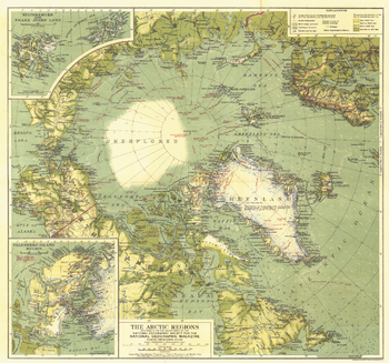
Arctic Regions - Published 1925
This bold map of the Arctic regions appeared in National Geographic Magazine in November of 1925 with the article "The MacMillan Arctic Expedition Returns." In this article, the world would discover the man who would soon be the most famous aviator-explorer of the era: Richard E. Byrd. Filled with detailed explorers' routes, this is a wonderful companion to the North Pole Regions map of 1907.
Page Size: 20 x 18.75 in (508 x 475 mm)