MapSherpa
Canada Streets Index
The MapSherpa Street product is ideal for the Business owner who needs local or regional road network information within a service delivery, catchment area or a sales territory. Information on the map highlights Municipal, Town and Zip Code boundaries. This multi-scale product for Canada uses the most current TomTom map data; you can count on this map showing the latest changes in your area. This product has been designed to make custom maps suitable from city to county scales, and anywhere in between. Rich regional maps include display highway infrastructure including, interchanges, weigh stations and tolls. Full street labelling, block numbers and street direction afford detailed city level maps. Infrastructure such as airports, hospitals, shopping malls, exhibition centers, industrial complexes and other business centric features are easily identifiable on the map.The map has an index grid (columns are labelled A, B, C, D… and rows are labelled 1, 2, 3, 4 …). The street index is provided as a separate Index file and lists the street name, address and grid coordinates. This multi-scale product for Canada is based on TomTom data and updated twice a year.
Canada Terrain
This versatile product allows you to get a wall map of anywhere in Canada. It has been designed to create beautiful maps that emphasize the natural landscape around places important to you.This product has been designed to make custom wall maps suitable from your local area to the whole country, and anywhere in between. 3D terrain shading provides a sense of relief of the surrounding topography enhanced by traditional topographic features such as elevation contours, landforms, lakes, and rivers. Also included are roads, rails, trails, buildings, and park boundaries.The cartography beautifully captures your connection to the landscape making this map ideal for showing off cottages, resorts, lakes and other favourite places. Makes a perfect personalized gift or memento of your latest adventure.
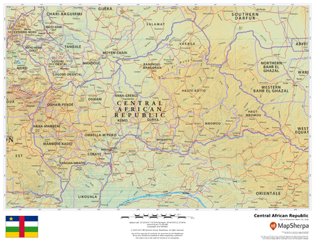
Central African Republic
This beautiful map shows physical and political features for the Central African Republic and surrounding areas. Relief shading and the use of different colours by height above sea level are both informative and attractive.
Page Size: 22 x 17 in (559 x 432 mm)
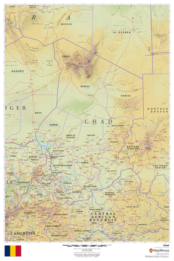
Chad
This beautiful map shows physical and political features for Chad and surrounding areas. Relief shading and the use of different colours by height above sea level are both informative and attractive.
Page Size: 24 x 36 in (610 x 914 mm)
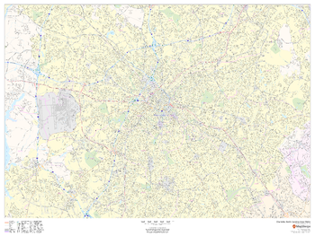
Charlotte, North Carolina Inner Metro - Landscape
This landscape-oriented map of central Charlotte, North Carolina shows detailed street level information including extensive street labeling. Ideal for planning of deliveries, home services, sales territories, real estate and much more. Base map features include all roads with major roads and highways labelled; neighborhood names; railways; high level land use such as parks and recreation areas, industrial areas and hospital campuses; and a variety of points of interest including schools, libraries, stadiums, museums, border crossings and more.
Page Size: 48 x 36 in (1219 x 914 mm)
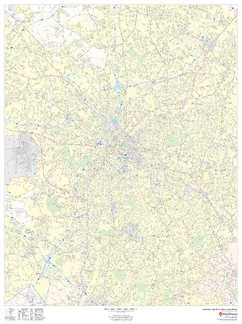
Charlotte, North Carolina Inner Metro - Portrait
This portrait-oriented map of central Charlotte, North Carolina shows detailed street level information including extensive street labeling. Ideal for planning of deliveries, home services, sales territories, real estate and much more. Base map features include all roads with major roads and highways labelled; neighborhood names; railways; high level land use such as parks and recreation areas, industrial areas and hospital campuses; and a variety of points of interest including schools, libraries, stadiums, museums, border crossings and more.
Page Size: 36 x 48 in (914 x 1219 mm)
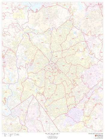
Charlotte, North Carolina ZIP Codes
This map of Charlotte shows ZIP code areas overlaid on a road map. Ideal for planning of deliveries, home services, sales territories, real estate and much more. Base map features include all roads with major roads and highways labelled; neighborhood names; railways; and high level land use such as parks and recreation areas, industrial areas and hospital campuses.
Page Size: 36 x 48 in (914 x 1219 mm)
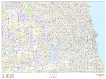
Chicago, Illinois Inner Metro - Landscape
This landscape-oriented map of central Chicago, Illinois shows detailed street level information including extensive street labeling. Ideal for planning of deliveries, home services, sales territories, real estate and much more. Base map features include all roads with major roads and highways labelled; neighborhood names; railways; high level land use such as parks and recreation areas, industrial areas and hospital campuses; and a variety of points of interest including schools, libraries, stadiums, museums, border crossings and more.
Page Size: 48 x 36 in (1219 x 914 mm)
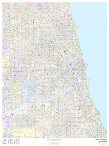
Chicago, Illinois Inner Metro - Portrait
This portrait-oriented map of central Chicago, Illinois shows detailed street level information including extensive street labeling. Ideal for planning of deliveries, home services, sales territories, real estate and much more. Base map features include all roads with major roads and highways labelled; neighborhood names; railways; high level land use such as parks and recreation areas, industrial areas and hospital campuses; and a variety of points of interest including schools, libraries, stadiums, museums, border crossings and more.
Page Size: 36 x 48 in (914 x 1219 mm)
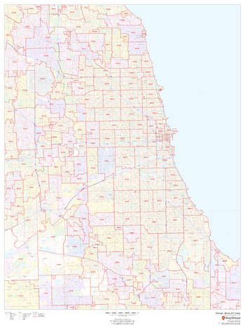
Chicago, Illinois ZIP Codes
This map of Chicago shows ZIP code areas overlaid on a road map. Ideal for planning of deliveries, home services, sales territories, real estate and much more. Base map features include all roads with major roads and highways labelled; neighborhood names; railways; and high level land use such as parks and recreation areas, industrial areas and hospital campuses.
Page Size: 36 x 48 in (914 x 1219 mm)
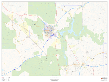
Clark County, Nevada
This map of Clark County, Nevada shows regional level information. Base map features include highways and major roads with highway numbering and high level land use such as parks and recreation areas.
Page Size: 48 x 36 in (1219 x 914 mm)
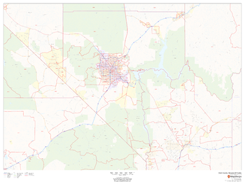
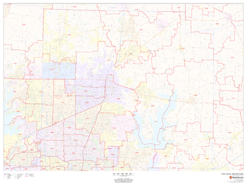
Clark County, Nevada ZIP Codes
This map of Clark County, Nevada shows ZIP code areas overlaid on a road map. Ideal for planning of deliveries, home services, sales territories, real estate and much more. Base map features include all roads with major roads and highways labelled; neighborhood names; and high level land use such as parks and recreation areas, industrial areas and hospital campuses.
Page Size: 48 x 36 in (1219 x 914 mm)
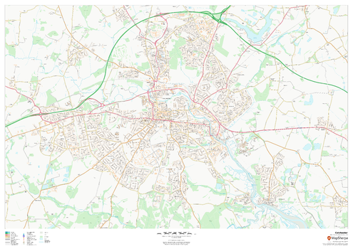
Colchester
This map of Colchester shows detailed street level information including extensive street labelling. Ideal for planning of deliveries, home services, sales territories, real estate and much more.
Page Size: 47 x 33.25 in (1189 x 841 mm)
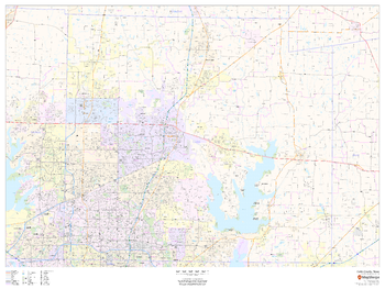
Collin County, Texas
This map of Collin County, Texas shows regional level information. Base map features include highways and major roads with labelling; neighborhood names; railways; high level land use such as parks and recreation areas, industrial areas and hospital campuses; and a selection of points of interest including transportation hubs like airports and train stations, tourist information, police stations and shopping centres. ZIP code boundaries are shown as a secondary map feature.
Page Size: 48 x 36 in (1219 x 914 mm)
Collin County, Texas ZIP Codes
This map of Collin County, Texas shows ZIP code areas overlaid on a road map. Ideal for planning of deliveries, home ervices, sales territories, real estate and much more. Base map features include all roads with major roads and highways labelled; neighborhood names; railways; and high level land use such as parks and recreation areas, industrial areas and hospital campuses.
Page Size: 48 x 36 in (1219 x 914 mm)
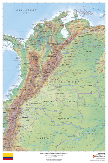
Colombia
This beautiful map shows physical and political features for Colombia and surrounding areas. Relief shading and the use of different colours by height above sea level are both informative and attractive.
Page Size: 24 x 36 in (610 x 914 mm)

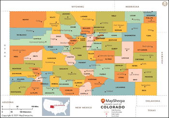
Colorado Counties Map - Extra Large
This map has been created exclusively for MapSherpa, and designed for reference or business use. Clear and clean colors & fonts matched with cartographic research makes this map of Colorado Counties Map easily readable and useful. The map shows the 64 counties of Colorado and their borders across the Centennial State.
Page Size: 60 x 42 in (1524 x 1063 mm)
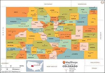
Colorado Counties Map - Large
This map has been created exclusively for MapSherpa, and designed for reference or business use. Clear and clean colors & fonts matched with cartographic research makes this map of Colorado Counties Map easily readable and useful. The map shows the 64 counties of Colorado and their borders across the Centennial State.
Page Size: 48 x 33.5 in (1219 x 850 mm)
Colorado Counties Map - Standard
This map has been created exclusively for MapSherpa, and designed for reference or business use. Clear and clean colors & fonts matched with cartographic research makes this map of Colorado Counties Map easily readable and useful. The map shows the 64 counties of Colorado and their borders across the Centennial State.
Page Size: 36 x 25.25 in (914 x 638 mm)
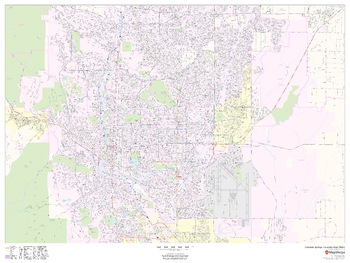
Colorado Springs, Colorado Inner Metro - Landscape
This landscape-oriented map of central Colorado Springs, Colorado shows detailed street level information including extensive street labeling. Ideal for planning of deliveries, home services, sales territories, real estate and much more. Base map features include all roads with major roads and highways labelled; neighborhood names; railways; high level land use such as parks and recreation areas, industrial areas and hospital campuses; and a variety of points of interest including schools, libraries, stadiums, museums, border crossings and more.
Page Size: 48 x 36 in (1219 x 914 mm)