


MapSherpa

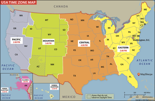
USA Time Zone Map
Clear and colorful, the USA Time Zone Map shows what time it is in the different time zones across the United States. The map notes all the 50 states and the time zones they fall into. Plus, it includes two small inset maps for Alaska and Hawaii, as each has its own time zones. The map also notes the states and areas that do not follow Daylight Savings Time.
Page Size: 36 x 23.75 in (914 x 601 mm)
USA Time Zone Map - Compact
Clear and colorful, the USA Time Zone Map shows what time it is in the different time zones across the United States. The map notes all the 50 states and the time zones they fall into. Plus, it includes two small inset maps for Alaska and Hawaii, as each has its own time zones. The map also notes the states and areas that do not follow Daylight Savings Time.
Page Size: 24.75 x 16.25 in (628 x 413 mm)

USA Time Zone Map - Extra Large
Clear and colorful, the USA Time Zone Map shows what time it is in the different time zones across the United States. The map notes all the 50 states and the time zones they fall into. Plus, it includes two small inset maps for Alaska and Hawaii, as each has its own time zones. The map also notes the states and areas that do not follow Daylight Savings Time.
Page Size: 61 x 40 in (1546 x 1016 mm)

USA Time Zone Map - Large
Clear and colorful, the USA Time Zone Map shows what time it is in the different time zones across the United States. The map notes all the 50 states and the time zones they fall into. Plus, it includes two small inset maps for Alaska and Hawaii, as each has its own time zones. The map also notes the states and areas that do not follow Daylight Savings Time.
Page Size: 48 x 31.75 in (1219 x 801 mm)
USA Topo - Modern
This product is derived from the modern USGS Topographic series updated on a 3 year cycle, and allows for the creation of detailed modern topographic maps for anywhere in the USA. Site centered maps can be made at scales between 1:12,000 and 1:40,000.
USA ZIP Codes
Custom 5-Digit ZIP Code maps can be made for anywhere in America. These attractive and informative maps include extensive geographic detail including: interstate and state highways; streets and street names at detailed scales; cities and towns; and, counties and state names and boundaries.Ideal for service delivery, retail siting, sales region planning and many other business and organizational functions.
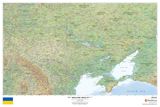
Ukraine
This beautiful map shows physical and political features for Ukraine and surrounding areas. Relief shading and the use of different colours by height above sea level are both informative and attractive.
Page Size: 36 x 24 in (914 x 610 mm)
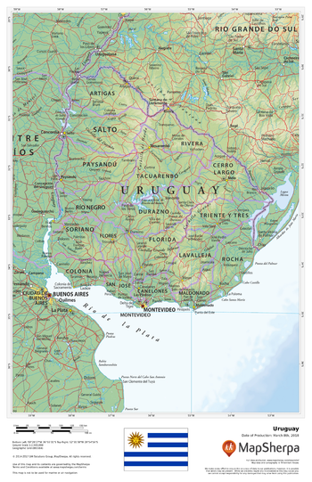
Uruguay
This beautiful map shows physical and political features for Uruguay and surrounding areas. Relief shading and the use of different colours by height above sea level are both informative and attractive.
Page Size: 11 x 17 in (279 x 432 mm)

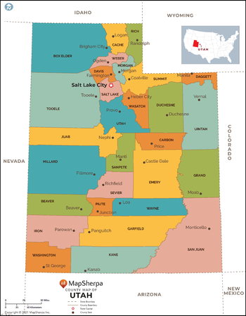
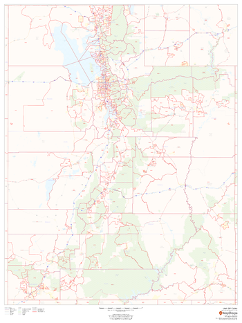
Utah Counties Map - Extra Large
This map has been created exclusively for MapSherpa, and designed for reference or business use. Clear and clean colors & fonts matched with cartographic research makes this map of Utah Counties Map easily readable and useful. The map shows the 29 counties of Utah and their borders across the Beehive State.
Page Size: 60 x 77.25 in (1524 x 1958 mm)
Utah Counties Map - Large
This map has been created exclusively for MapSherpa, and designed for reference or business use. Clear and clean colors & fonts matched with cartographic research makes this map of Utah Counties Map easily readable and useful. The map shows the 29 counties of Utah and their borders across the Beehive State.
Page Size: 48 x 61.75 in (1219 x 1566 mm)

Utah Counties Map - Standard
This map has been created exclusively for MapSherpa, and designed for reference or business use. Clear and clean colors & fonts matched with cartographic research makes this map of Utah Counties Map easily readable and useful. The map shows the 29 counties of Utah and their borders across the Beehive State.
Page Size: 36 x 46.25 in (914 x 1175 mm)
Utah ZIP Code Map
This map of Utah shows ZIP codes overlaid on a road map. Base map features include municipality and county boundaries, major road network features, and state and national parks and conservation areas.
Page Size: 36 x 48 in (914 x 1219 mm)

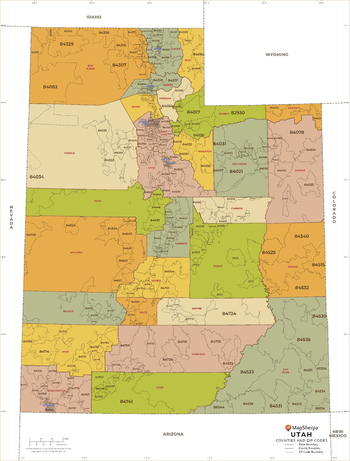
Utah ZIP Code Map with Counties - Extra Large
This map has been created exclusively for MapSherpa, and designed for business or reference use. Clear and clean colors & fonts matched with cartographic research makes this Utah Zip Code Map with Counties easily readable and useful. The map shows the 29 counties of Utah and the borders of the over 200 zip codes across the Beehive State.
Page Size: 60 x 79.25 in (1524 x 2008 mm)

Utah ZIP Code Map with Counties - Large
This map has been created exclusively for MapSherpa, and designed for business or reference use. Clear and clean colors & fonts matched with cartographic research makes this Utah Zip Code Map with Counties easily readable and useful. The map shows the 29 counties of Utah and the borders of the over 200 zip codes across the Beehive State.
Page Size: 48 x 63.5 in (1219 x 1607 mm)
Utah ZIP Code Map with Counties - Standard
This map has been created exclusively for MapSherpa, and designed for business or reference use. Clear and clean colors & fonts matched with cartographic research makes this Utah Zip Code Map with Counties easily readable and useful. The map shows the 29 counties of Utah and the borders of the over 200 zip codes across the Beehive State.
Page Size: 36 x 47.5 in (914 x 1205 mm)
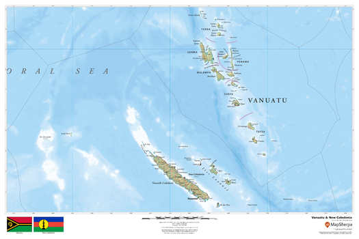
Vanuatu & New Caledonia
This beautiful map shows physical and political features for country of Vanuatu and the French overseas territory of New Caledonia. Relief shading and the use of different colours by height above sea level are both informative and attractive.
Page Size: 36 x 24 in (914 x 610 mm)
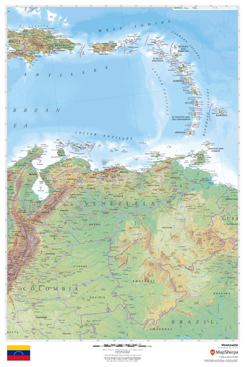
Venezuela
This beautiful map shows physical and political features for Venezuela and surrounding areas. Relief shading and the use of different colours by height above sea level are both informative and attractive.
Page Size: 24 x 36 in (610 x 914 mm)
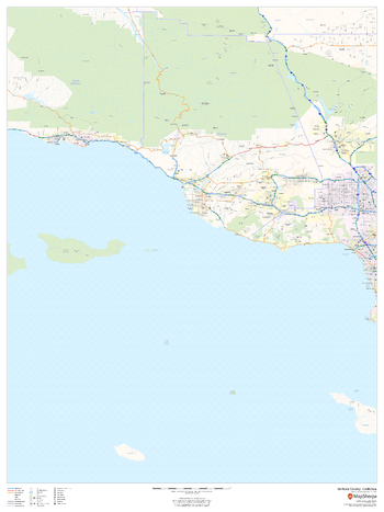
Ventura County, California
This map of Ventura County, California shows regional level information. Base map features include highways and major roads with labelling; high level land use such as parks and recreation areas; and a selection of points of interest including transportation hubs like airports and train stations, tourist information and police stations.
Page Size: 36 x 48 in (914 x 1219 mm)
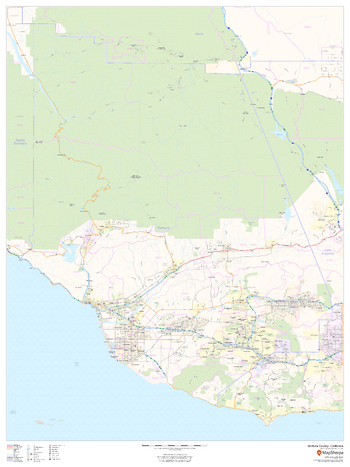
Ventura County, California (Mainland)
This map of the mainland portion of Ventura County, California shows regional level information. Base map features include highways and major roads with labelling; railways; high level land use such as parks and recreation areas; and a selection of points of interest including transportation hubs like airports and train stations, tourist information and police stations. ZIP code boundaries are shown as a secondary map feature.
Page Size: 36 x 48 in (914 x 1219 mm)
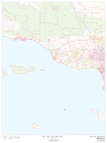
Ventura County, California ZIP Codes
This map of Ventura County, California shows ZIP code areas overlaid on a road map. Ideal for planning of deliveries, home ervices, sales territories, real estate and much more. Base map features include all roads with major roads and highways labelled; neighborhood names; railways; and high level land use such as parks and recreation areas, industrial areas and hospital campuses.
Page Size: 36 x 48 in (914 x 1219 mm)