


MapSherpa
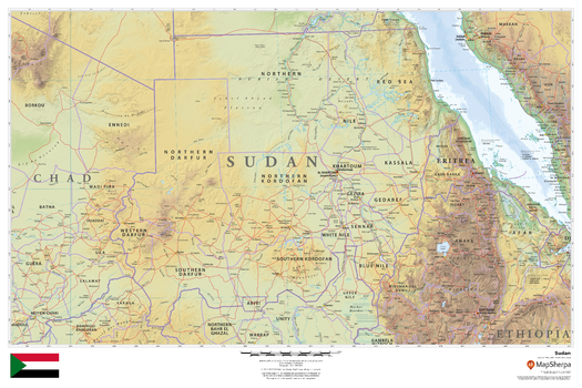
Sudan
This beautiful map shows physical and political features for Sudan and surrounding areas. Relief shading and the use of different colours by height above sea level are both informative and attractive.
Page Size: 36 x 24 in (914 x 610 mm)
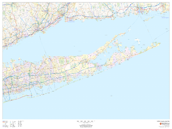
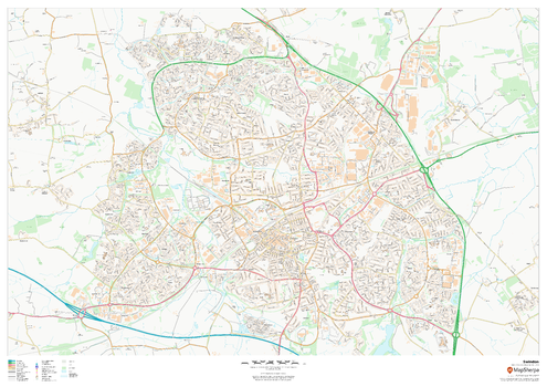
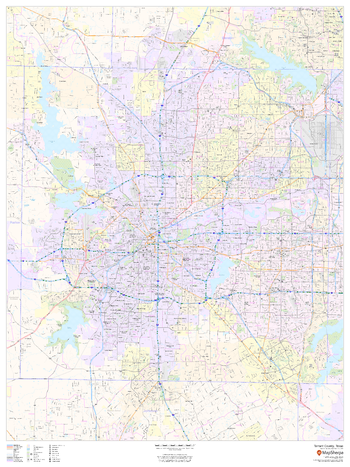
Suffolk County, New York
This map of Suffolk County, New York shows regional level information. Base map features include highways and major roads with labelling; railways; high level land use such as parks and recreation areas; and a selection of points of interest including transportation hubs like airports and train stations, tourist information and police stations.
Page Size: 48 x 36 in (1219 x 914 mm)
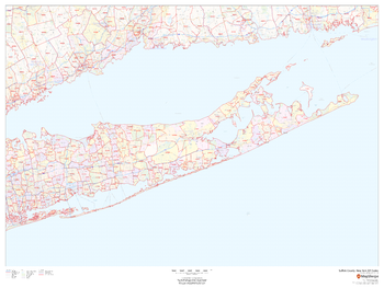
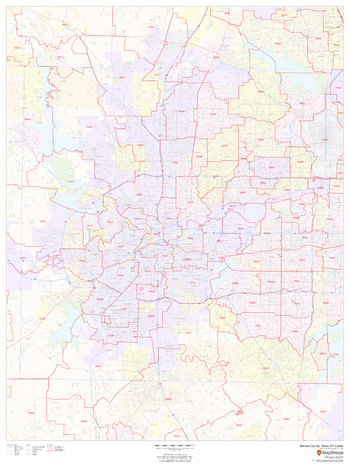
Suffolk County, New York ZIP Codes
This map of Suffolk County, New York shows ZIP code areas overlaid on a road map. Ideal for planning of deliveries, home services, sales territories, real estate and much more. Base map features include all roads with major roads and highways labelled; neighborhood names; railways; and high level land use such as parks and recreation areas, industrial areas and hospital campuses.
Page Size: 48 x 36 in (1219 x 914 mm)
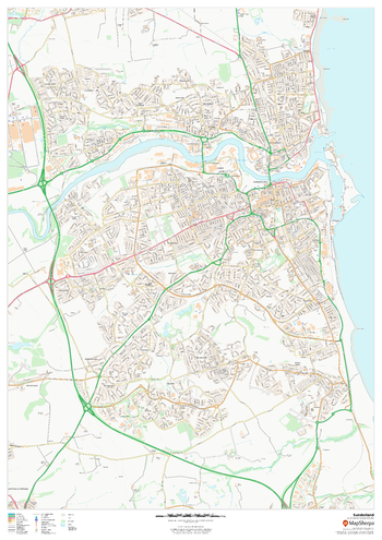
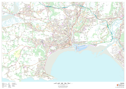
Sunderland
This map of Sunderland shows detailed street level information including extensive street labelling. Ideal for planning of deliveries, home services, sales territories, real estate and much more.
Page Size: 33.25 x 47 in (841 x 1189 mm)
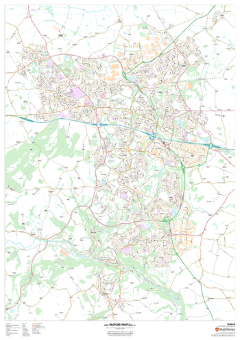
Swansea
This map of Swansea shows detailed street level information including extensive street labelling. Ideal for planning of deliveries, home services, sales territories, real estate and much more.
Page Size: 47 x 33.25 in (1189 x 841 mm)
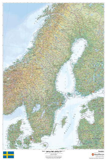
Sweden
This beautiful map shows physical and political features for Sweden and surrounding areas. Relief shading and the use of different colours by height above sea level are both informative and attractive.
Page Size: 24 x 36 in (610 x 914 mm)
Swindon
This map of Swindon shows detailed street level information including extensive street labelling. Ideal for planning of deliveries, home services, sales territories, real estate and much more.
Page Size: 47 x 33.25 in (1189 x 841 mm)
Tactical Pilotage Charts
Published by the United States government in the 1980s and 1990s, Tactical Pilotage Charts are topographic maps with detailed aeronautical information. Towns, villages, pipelines, roads, railroads and similar cultural information are also indicated. Coverage includes the Mediterranean, Africa, the Middle East, across the Himalayas to Japan. Individual map sheets have been combined into a seamless layer. Suitable for print maps between 1:250,000 and 1:1,000,000.
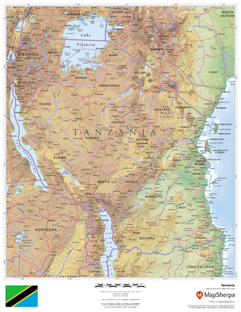
Tanzania
This beautiful map shows physical and political features for Tanzania and surrounding areas. Relief shading and the use of different colours by height above sea level are both informative and attractive.
Page Size: 17 x 22 in (432 x 559 mm)
Tarrant County, Texas
This map of Tarrant County, Texas shows regional level information. Base map features include highways and major roads with labelling; neighborhood names; railways; high level land use such as parks and recreation areas, industrial areas and hospital campuses; and a selection of points of interest including transportation hubs like airports and train stations, tourist information, police stations and shopping centres. ZIP code boundaries are shown as a secondary map feature.
Page Size: 36 x 48 in (914 x 1219 mm)
Tarrant County, Texas ZIP Codes
This map of Tarrant County, Texas shows ZIP code areas overlaid on a road map. Ideal for planning of deliveries, home services, sales territories, real estate and much more. Base map features include all roads with major roads and highways labelled; neighborhood names; railways; and high level land use such as parks and recreation areas, industrial areas and hospital campuses.
Page Size: 36 x 48 in (914 x 1219 mm)
Telford
This map of Telford shows detailed street level information including extensive street labelling. Ideal for planning of deliveries, home services, sales territories, real estate and much more.
Page Size: 33.25 x 47 in (841 x 1189 mm)

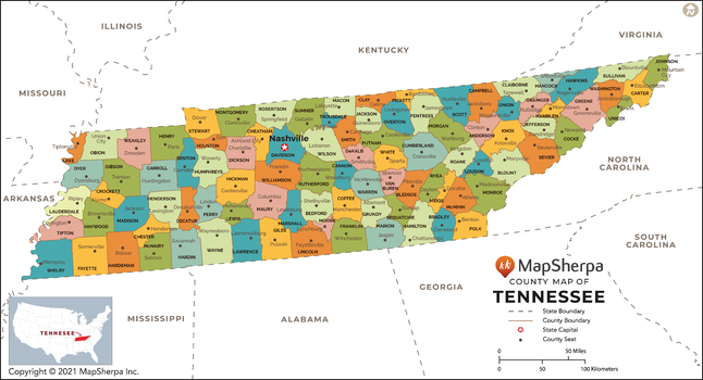
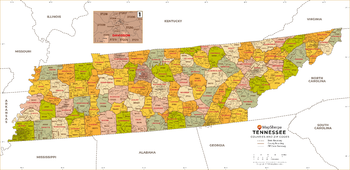
Tennessee Counties Map - Extra Large
This map has been created exclusively for MapSherpa, and designed for reference or business use. Clear and clean colors & fonts matched with cartographic research makes this map of Tennessee Counties Map easily readable and useful. The map shows the 95 counties of Tennessee and their borders across the Volunteer State.
Page Size: 60 x 32.5 in (1524 x 825 mm)
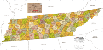
Tennessee Counties Map - Large
This map has been created exclusively for MapSherpa, and designed for reference or business use. Clear and clean colors & fonts matched with cartographic research makes this map of Tennessee Counties Map easily readable and useful. The map shows the 95 counties of Tennessee and their borders across the Volunteer State.
Page Size: 48 x 26 in (1219 x 660 mm)

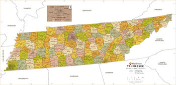
Tennessee Counties Map - Standard
This map has been created exclusively for MapSherpa, and designed for reference or business use. Clear and clean colors & fonts matched with cartographic research makes this map of Tennessee Counties Map easily readable and useful. The map shows the 95 counties of Tennessee and their borders across the Volunteer State.
Page Size: 36 x 19.5 in (914 x 495 mm)
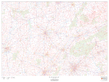
Tennessee ZIP Code Map
This map of Tennessee shows ZIP codes overlaid on a road map. Base map features include county boundaries, major road network features, and state and national parks and conservation areas.
Page Size: 48 x 36 in (1219 x 914 mm)
Tennessee ZIP Code Map with Counties - Extra Large
This map has been created exclusively for MapSherpa, and designed for business or reference use. Clear and clean colors & fonts matched with cartographic research makes this Tennessee Zip Code Map with Counties easily readable and useful. The map shows the 95 counties of Tennessee and the borders of the 627 zip codes across the Volunteer State.
Page Size: 60 x 29.25 in (1524 x 739 mm)
Tennessee ZIP Code Map with Counties - Large
This map has been created exclusively for MapSherpa, and designed for business or reference use. Clear and clean colors & fonts matched with cartographic research makes this Tennessee Zip Code Map with Counties easily readable and useful. The map shows the 95 counties of Tennessee and the borders of the 627 zip codes across the Volunteer State.
Page Size: 48 x 23.5 in (1219 x 591 mm)
Tennessee ZIP Code Map with Counties - Standard
This map has been created exclusively for MapSherpa, and designed for business or reference use. Clear and clean colors & fonts matched with cartographic research makes this Tennessee Zip Code Map with Counties easily readable and useful. The map shows the 95 counties of Tennessee and the borders of the 627 zip codes across the Volunteer State.
Page Size: 36 x 17.5 in (914 x 443 mm)
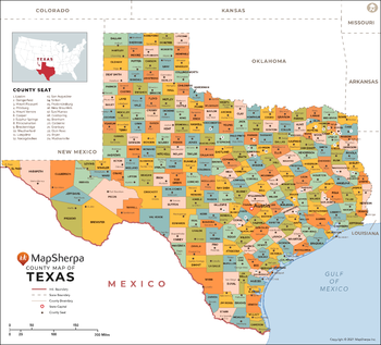
Texas Counties Map - Extra Large
This map has been created exclusively for MapSherpa, and designed for reference or business use. Clear and clean colors & fonts matched with cartographic research makes this map of Texas Counties Map easily readable and useful. The map shows the 254 counties of Texas and their borders across the Lone Star State.
Page Size: 60 x 54.5 in (1524 x 1380 mm)