


MapSherpa
Regional Relief - Southern Europe
These beautiful maps show Political and Physical features for Southern Europe; from Spain and Portugal in the west, to Ukraine and Turkey in the east. Maps contain extensive country specific features and text. Relief shading and the use of different colors by height above sea level are both informative and attractive. Custom maps can be made at scales between 1:900,000 and 1:3,500,000.
Regional Relief - Southern South America
These beautiful maps show Political and Physical features for Southern South America from; Paraguay and Uruguay in the north, to the Falkland Islands in the south. Maps contain extensive country specific features and text. Relief shading and the use of different colors by height above sea level are both informative and attractive. Custom maps can be made at scales between 1:1,250,000 and 1:5,000,000.
Regional Relief - United Kingdom & Ireland
These beautiful maps show Political and Physical features for the United Kingdom, Ireland as well as Benelux in mainland Europe. Maps contain extensive country specific features and text. Relief shading and the use of different colors by height above sea level are both informative and attractive. Custom maps can be made at scales between 1:300,000 and 1:1,500,000.
Regional Relief - United States
These beautiful maps show Political and Physical features for the lower 48 U.S. States. Maps contain extensive country specific features and text. Relief shading and the use of different colors by height above sea level are both informative and attractive. Custom maps can be made at scales between 1:1,000,000 and 1:4,000,000.
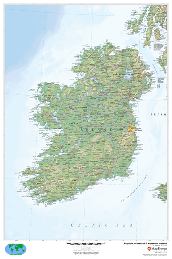
Republic of Ireland & Northern Ireland
This beautiful map shows physical and political features for the Republic of Ireland and Northern Ireland. Relief shading and the use of different colours by height above sea level are both informative and attractive.
Page Size: 24 x 36 in (610 x 914 mm)
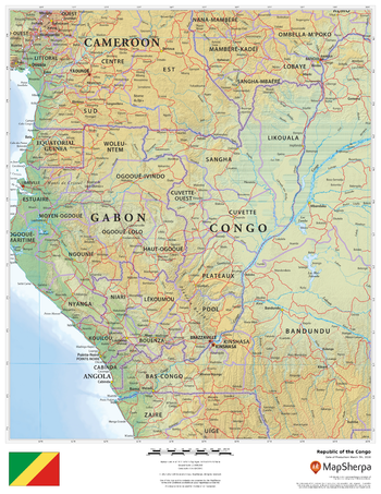
Republic of the Congo
This beautiful map shows physical and political features for the Republic of the Congo and surrounding areas. Relief shading and the use of different colours by height above sea level are both informative and attractive.
Page Size: 17 x 22 in (432 x 559 mm)

Rhode Island Counties Map - Extra Large
This map has been created exclusively for MapSherpa, and designed for reference or business use. Clear and clean colors & fonts matched with cartographic research makes this map of the 5 Rhode Island counties easily readable and useful.
Page Size: 60 x 60 in (1524 x 1524 mm)

Rhode Island Counties Map - Large
This map has been created exclusively for MapSherpa, and designed for reference or business use. Clear and clean colors & fonts matched with cartographic research makes this map of the 5 Rhode Island counties easily readable and useful.
Page Size: 48 x 48 in (1219 x 1219 mm)
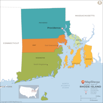
Rhode Island Counties Map - Standard
This map has been created exclusively for MapSherpa, and designed for reference or business use. Clear and clean colors & fonts matched with cartographic research makes this map of the 5 Rhode Island counties easily readable and useful.
Page Size: 36 x 36 in (914 x 914 mm)
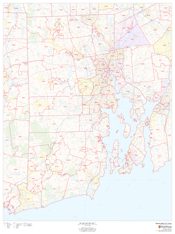
Rhode Island ZIP Code Map
This map of Rhode Island shows ZIP code areas overlaid on a road map. Ideal for planning of deliveries, home services, sales territories, real estate and much more. Base map features include all roads with major roads and highways labelled; municipality and county boundaries; neighborhood names; railways; and high level land use such as parks and recreation areas, industrial areas and hospital campuses.
Page Size: 36 x 48 in (914 x 1219 mm)
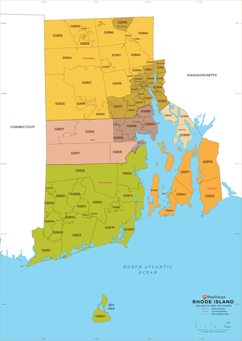
Rhode Island ZIP Code Map with Counties - Extra Large
This map has been created exclusively for MapSherpa, and designed for business or reference use. Clear and clean colors & fonts matched with cartographic research makes this map of Rhode Island's counties and ZIP codes easily readable and useful.
Page Size: 60 x 84.5 in (1524 x 2141 mm)

Rhode Island ZIP Code Map with Counties - Large
This map has been created exclusively for MapSherpa, and designed for business or reference use. Clear and clean colors & fonts matched with cartographic research makes this map of Rhode Island's counties and ZIP codes easily readable and useful.
Page Size: 48 x 67.5 in (1219 x 1713 mm)

Rhode Island ZIP Code Map with Counties - Standard
This map has been created exclusively for MapSherpa, and designed for business or reference use. Clear and clean colors & fonts matched with cartographic research makes this map of Rhode Island's counties and ZIP codes easily readable and useful.
Page Size: 36 x 50.75 in (914 x 1284 mm)
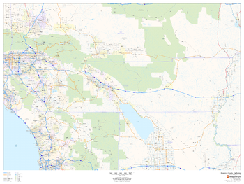
Riverside County, California
This map of Riverside County, California shows regional level information. Base map features include highways and major roads with highway numbering and high level land use such as parks and recreation areas.
Page Size: 48 x 36 in (1219 x 914 mm)
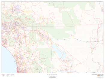
Riverside County, California ZIP Codes
This map of Riverside County, California shows ZIP code areas overlaid on a road map. Ideal for planning of deliveries, home services, sales territories, real estate and much more. Base map features include all roads with major roads and highways labelled; neighborhood names; and high level land use such as parks and recreation areas, industrial areas and hospital campuses.
Page Size: 48 x 36 in (1219 x 914 mm)
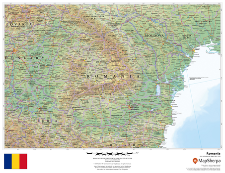
Romania
This beautiful map shows physical and political features for Romania and surrounding areas. Relief shading and the use of different colours by height above sea level are both informative and attractive.
Page Size: 22 x 17 in (559 x 432 mm)
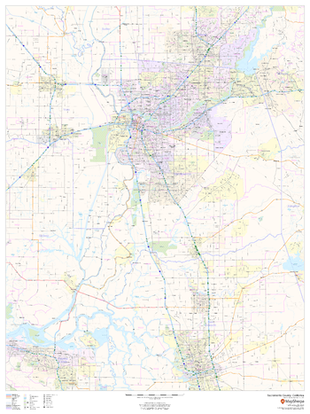
Sacramento County, California
This map of Sacramento County, California shows regional level information. Base map features include highways and major roads with labelling; railways; high level land use such as parks and recreation areas; and a selection of points of interest including transportation hubs like airports and train stations, tourist information and police stations. ZIP code boundaries are shown as a secondary map feature.
Page Size: 36 x 48 in (914 x 1219 mm)
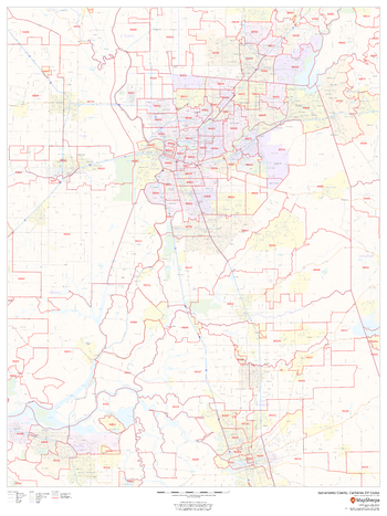
Sacramento County, California ZIP Codes
This map of Sacramento County, California shows ZIP code areas overlaid on a road map. Ideal for planning of deliveries, home services, sales territories, real estate and much more. Base map features include all roads with major roads and highways labelled; neighborhood names; railways; and high level land use such as parks and recreation areas, industrial areas and hospital campuses.
Page Size: 36 x 48 in (914 x 1219 mm)
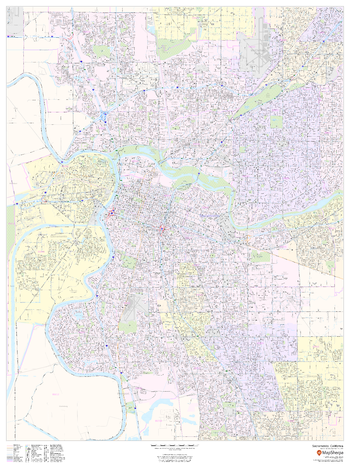
Sacramento, California - Portrait
This portrait-oriented map of Sacramento, California shows detailed street level information including extensive street labeling. Ideal for planning of deliveries, home services, sales territories, real estate and much more. Base map features include all roads with major roads and highways labelled; neighborhood names; railways; high level land use such as parks and recreation areas, industrial areas and hospital campuses; and a variety of points of interest including schools, libraries, stadiums, museums, border crossings and more.
Page Size: 36 x 48 in (914 x 1219 mm)
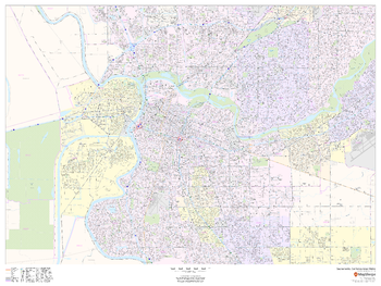
Sacramento, California Inner Metro - Landscape
This landscape-oriented map of central Sacramento, California shows detailed street level information including extensive street labeling. Ideal for planning of deliveries, home services, sales territories, real estate and much more. Base map features include all roads with major roads and highways labelled; neighborhood names; railways; high level land use such as parks and recreation areas, industrial areas and hospital campuses; and a variety of points of interest including schools, libraries, stadiums, museums, border crossings and more.
Page Size: 48 x 36 in (1219 x 914 mm)