MapSherpa

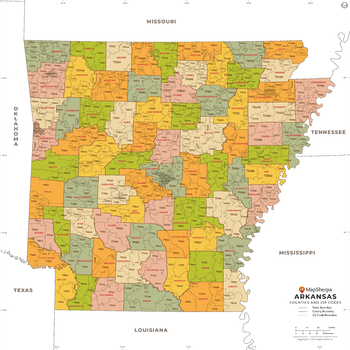
Arkansas ZIP Code Map with Counties - Extra Large
This map has been created exclusively for MapSherpa, and designed for business or reference use. Clear and clean colors & fonts matched with cartographic research makes this map of Arkansas' counties and ZIP codes easily readable and useful.
Page Size: 60 x 60 in (1524 x 1524 mm)

Arkansas ZIP Code Map with Counties - Large
This map has been created exclusively for MapSherpa, and designed for business or reference use. Clear and clean colors & fonts matched with cartographic research makes this map of Arkansas' counties and ZIP codes easily readable and useful.
Page Size: 48 x 48 in (1219 x 1219 mm)
Arkansas ZIP Code Map with Counties - Standard
This map has been created exclusively for MapSherpa, and designed for business or reference use. Clear and clean colors & fonts matched with cartographic research makes this map of Arkansas' counties and ZIP codes easily readable and useful.
Page Size: 36 x 36 in (914 x 914 mm)
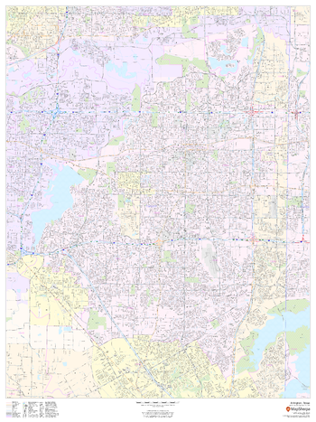
Arlington, Texas - Portrait
This portrait-oriented map of Arlington, Texas shows detailed street level information including extensive street labeling. Ideal for planning of deliveries, home services, sales territories, real estate and much more. Base map features include all roads with major roads and highways labelled; neighborhood names; railways; high level land use such as parks and recreation areas, industrial areas and hospital campuses; and a variety of points of interest including schools, libraries, stadiums, museums, border crossings and more.
Page Size: 36 x 48 in (914 x 1219 mm)
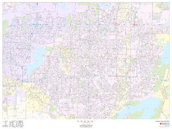
Arlington, Texas Inner Metro - Landscape
This landscape-oriented map of central Arlington, Texas shows detailed street level information including extensive street labeling. Ideal for planning of deliveries, home services, sales territories, real estate and much more. Base map features include all roads with major roads and highways labelled; neighborhood names; railways; high level land use such as parks and recreation areas, industrial areas and hospital campuses; and a variety of points of interest including schools, libraries, stadiums, museums, border crossings and more.
Page Size: 48 x 36 in (1219 x 914 mm)
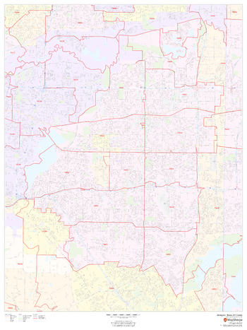
Arlington, Texas ZIP Codes
This map of Arlington, Texas shows ZIP code areas overlaid on a road map. Ideal for planning of deliveries, home services, sales territories, real estate and much more. Base map features include all roads with major roads and highways labelled; neighborhood names; railways; and high level land use such as parks and recreation areas, industrial areas and hospital campuses.
Page Size: 36 x 48 in (914 x 1219 mm)
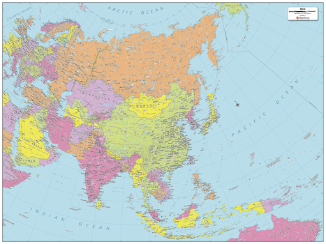
Asia Political Map
Explore the world’s largest continent with this map of Asia created specifically for MapSherpa. Map shows the multitude of countries that make up the most populated continent. Stretching from the Arctic in the north to the Pacific Oceans, and to where east-meets-west, this map prominently shows; national capitals, primary cities & towns, primary water features, mountain ranges and all time zones. With multiple sizes available, this is the perfect reference map for home, office, or school use.
Page Size: 32 x 24 in (813 x 610 mm)
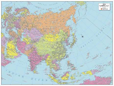
Asia Political Map - Compact
Explore the world’s largest continent with this map of Asia created specifically for MapSherpa. Map shows the multitude of countries that make up the most populated continent. Stretching from the Arctic in the north to the Pacific Oceans, and to where east-meets-west, this map prominently shows; national capitals, primary cities & towns, primary water features, mountain ranges and all time zones. With multiple sizes available, this is the perfect reference map for home, office, or school use.
Page Size: 21.5 x 16 in (540 x 406 mm)
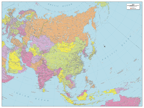
Asia Political Map - Large
Explore the world’s largest continent with this map of Asia created specifically for MapSherpa. Map shows the multitude of countries that make up the most populated continent. Stretching from the Arctic in the north to the Pacific Oceans, and to where east-meets-west, this map prominently shows; national capitals, primary cities & towns, primary water features, mountain ranges and all time zones. With multiple sizes available, this is the perfect reference map for home, office, or school use.
Page Size: 48 x 36 in (1219 x 914 mm)
Atlanta, Georgia Inner Metro - Landscape
This landscape-oriented map of central Atlanta, Georgia shows detailed street level information including extensive street labeling. Ideal for planning of deliveries, home services, sales territories, real estate and much more. Base map features include all roads with major roads and highways labelled; neighborhood names; railways; high level land use such as parks and recreation areas, industrial areas and hospital campuses; and a variety of points of interest including schools, libraries, stadiums, museums, border crossings and more.
Page Size: 48 x 36 in (1219 x 914 mm)
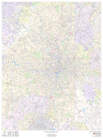
Atlanta, Georgia Inner Metro - Portrait
This portrait-oriented map of central Atlanta, Georgia shows detailed street level information including extensive street labeling. Ideal for planning of deliveries, home services, sales territories, real estate and much more. Base map features include all roads with major roads and highways labelled; neighborhood names; railways; high level land use such as parks and recreation areas, industrial areas and hospital campuses; and a variety of points of interest including schools, libraries, stadiums, museums, border crossings and more.
Page Size: 36 x 48 in (914 x 1219 mm)
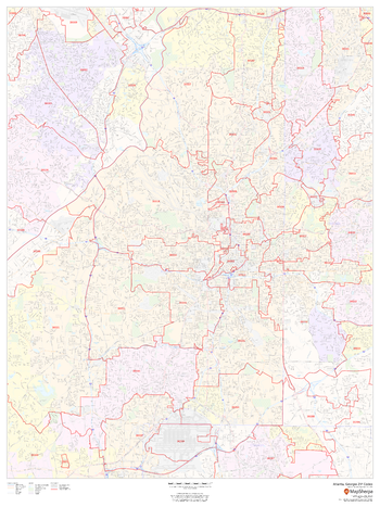
Atlanta, Georgia ZIP Codes
This map of Atlanta, Georgia shows ZIP code areas overlaid on a road map. Ideal for planning of deliveries, home services, sales territories, real estate and much more. Base map features include all roads with major roads and highways labelled; neighborhood names; railways; and high level land use such as parks and recreation areas, industrial areas and hospital campuses.
Page Size: 36 x 48 in (914 x 1219 mm)
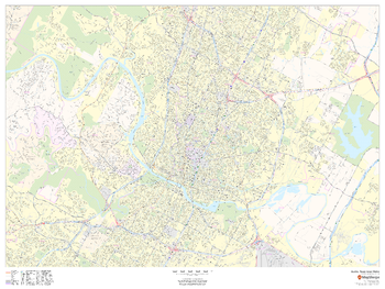
Austin, Texas Inner Metro - Landscape
This landscape-oriented map of central Austin, Texas shows detailed street level information including extensive street labeling. Ideal for planning of deliveries, home services, sales territories, real estate and much more. Base map features include all roads with major roads and highways labelled; neighborhood names; railways; high level land use such as parks and recreation areas, industrial areas and hospital campuses; and a variety of points of interest including schools, libraries, stadiums, museums, border crossings and more.
Page Size: 48 x 36 in (1219 x 914 mm)
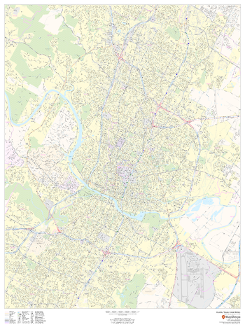
Austin, Texas Inner Metro - Portrait
This portrait-oriented map of central Austin, Texas shows detailed street level information including extensive street labeling. Ideal for planning of deliveries, home services, sales territories, real estate and much more. Base map features include all roads with major roads and highways labelled; neighborhood names; railways; high level land use such as parks and recreation areas, industrial areas and hospital campuses; and a variety of points of interest including schools, libraries, stadiums, museums, border crossings and more.
Page Size: 36 x 48 in (914 x 1219 mm)
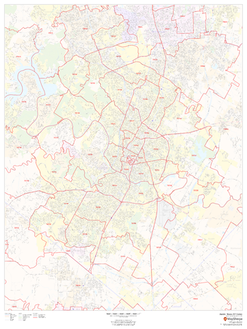
Austin, Texas ZIP Codes
This map of Austin shows ZIP code areas overlaid on a road map. Ideal for planning of deliveries, home services, sales territories, real estate and much more. Base map features include all roads with major roads and highways labelled; neighborhood names; railways; and high level land use such as parks and recreation areas, industrial areas and hospital campuses.
Page Size: 36 x 48 in (914 x 1219 mm)
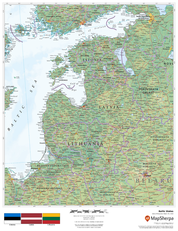
Baltic States
This beautiful map shows physical and political features for the Baltic States - Estonia, Latvia and Lithuania - and surrounding areas. Relief shading and the use of different colours by height above sea level are both informative and attractive.
Page Size: 17 x 22 in (432 x 559 mm)
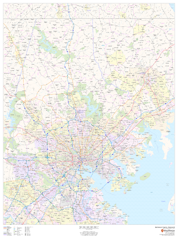
Baltimore County, Maryland
This map of Baltimore County, Maryland shows regional level information. Base map features include highways and major roads with labelling; neighborhood names; railways; high level land use such as parks and recreation areas, industrial areas and hospital campuses; and a selection of points of interest including transportation hubs like airports and train stations, tourist information, police stations and shopping centres. ZIP code boundaries are shown as a secondary map feature.
Page Size: 36 x 48 in (914 x 1219 mm)
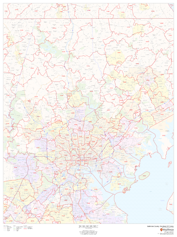
Baltimore County, Maryland ZIP Codes
This map of Baltimore County, Maryland shows ZIP code areas overlaid on a road map. Ideal for planning of deliveries, home ervices, sales territories, real estate and much more. Base map features include all roads with major roads and highways labelled; neighborhood names; railways; and high level land use such as parks and recreation areas, industrial areas and hospital campuses.
Page Size: 36 x 48 in (914 x 1219 mm)
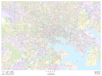
Baltimore, Maryland - Landscape
This landscape-oriented map of Baltimore, Maryland shows detailed street level information including extensive street labeling. Ideal for planning of deliveries, home services, sales territories, real estate and much more. Base map features include all roads with major roads and highways labelled; neighborhood names; railways; high level land use such as parks and recreation areas, industrial areas and hospital campuses; and a variety of points of interest including schools, libraries, stadiums, museums, border crossings and more.
Page Size: 48 x 36 in (1219 x 914 mm)
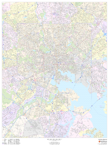
Baltimore, Maryland - Portrait
This portrait-oriented map of Baltimore, Maryland shows detailed street level information including extensive street labeling. Ideal for planning of deliveries, home services, sales territories, real estate and much more. Base map features include all roads with major roads and highways labelled; neighborhood names; railways; high level land use such as parks and recreation areas, industrial areas and hospital campuses; and a variety of points of interest including schools, libraries, stadiums, museums, border crossings and more.
Page Size: 36 x 48 in (914 x 1219 mm)