


MapSherpa
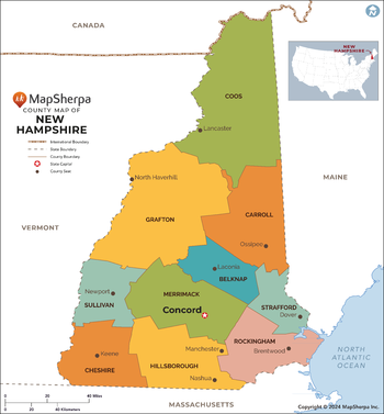
New Hampshire Counties Map - Extra Large
This map has been created exclusively for MapSherpa, and designed for reference or business use. Clear and clean colors & fonts matched with cartographic research makes this map of the 10 New Hampshire counties easily readable and useful.
Page Size: 60 x 64.75 in (1524 x 1642 mm)

New Hampshire Counties Map - Large
This map has been created exclusively for MapSherpa, and designed for reference or business use. Clear and clean colors & fonts matched with cartographic research makes this map of the 10 New Hampshire counties easily readable and useful.
Page Size: 48 x 51.75 in (1219 x 1314 mm)

New Hampshire Counties Map - Standard
This map has been created exclusively for MapSherpa, and designed for reference or business use. Clear and clean colors & fonts matched with cartographic research makes this map of the 10 New Hampshire counties easily readable and useful.
Page Size: 36 x 39 in (914 x 985 mm)
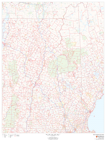
New Hampshire ZIP Code Map
This map of New Hampshire shows ZIP code areas overlaid on a road map. Ideal for planning of deliveries, home services, sales territories, real estate and much more. Base map features include all roads with major roads and highways labelled, municipality and county boundaries, neighborhood names, railways, and high level land use such as parks and recreation areas
Page Size: 36 x 48 in (914 x 1219 mm)
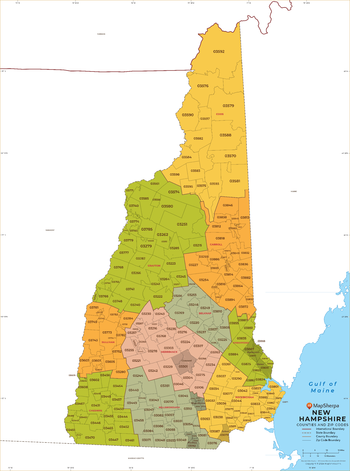
New Hampshire ZIP Code Map with Counties - Extra Large
This map has been created exclusively for MapSherpa, and designed for business or reference use. Clear and clean colors & fonts matched with cartographic research makes this map of New Hampshire's counties and ZIP codes easily readable and useful.
Page Size: 60 x 81 in (1524 x 2053 mm)

New Hampshire ZIP Code Map with Counties - Large
This map has been created exclusively for MapSherpa, and designed for business or reference use. Clear and clean colors & fonts matched with cartographic research makes this map of New Hampshire's counties and ZIP codes easily readable and useful.
Page Size: 48 x 64.75 in (1219 x 1642 mm)

New Hampshire ZIP Code Map with Counties - Standard
This map has been created exclusively for MapSherpa, and designed for business or reference use. Clear and clean colors & fonts matched with cartographic research makes this map of New Hampshire's counties and ZIP codes easily readable and useful.
Page Size: 36 x 48.5 in (914 x 1232 mm)
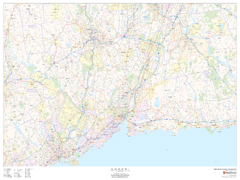
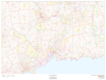
New Haven County, Connecticut
This map of New Haven County, Connecticut shows regional level information. Base map features include highways and major roads with labelling; neighborhood names; railways; high level land use such as parks and recreation areas, industrial areas and hospital campuses; and a selection of points of interest including transportation hubs like airports and train stations, tourist information, police stations and shopping centres. ZIP code boundaries are shown as a secondary map feature.
Page Size: 48 x 36 in (1219 x 914 mm)
New Haven County, Connecticut ZIP Codes
This map of New Haven County, Connecticut shows ZIP code areas overlaid on a road map. Ideal for planning of deliveries, home ervices, sales territories, real estate and much more. Base map features include all roads with major roads and highways labelled; neighborhood names; railways; and high level land use such as parks and recreation areas, industrial areas and hospital campuses.
Page Size: 48 x 36 in (1219 x 914 mm)
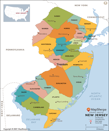
New Jersey Counties Map - Extra Large
This map has been created exclusively for MapSherpa, and designed for reference or business use. Clear and clean colors & fonts matched with cartographic research makes this map of New Jersey Counties Map easily readable and useful. The map shows the 21 counties of New Jersey and their borders across the Garden State.
Page Size: 60 x 72.25 in (1524 x 1829 mm)

New Jersey Counties Map - Large
This map has been created exclusively for MapSherpa, and designed for reference or business use. Clear and clean colors & fonts matched with cartographic research makes this map of New Jersey Counties Map easily readable and useful. The map shows the 21 counties of New Jersey and their borders across the Garden State.
Page Size: 48 x 57.75 in (1219 x 1463 mm)

New Jersey Counties Map - Standard
This map has been created exclusively for MapSherpa, and designed for reference or business use. Clear and clean colors & fonts matched with cartographic research makes this map of New Jersey Counties Map easily readable and useful. The map shows the 21 counties of New Jersey and their borders across the Garden State.
Page Size: 36 x 43.25 in (914 x 1097 mm)
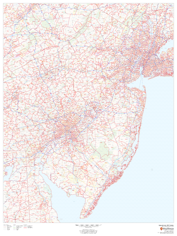
New Jersey ZIP Code Map
This map of New Jersey shows ZIP code areas overlaid on a road map. Ideal for planning of deliveries, home services, sales territories, real estate and much more. Base map features include all roads with major roads and highways labelled, municipality and county boundaries, neighborhood names, railways, and high level land use such as parks and recreation areas
Page Size: 36 x 48 in (914 x 1219 mm)
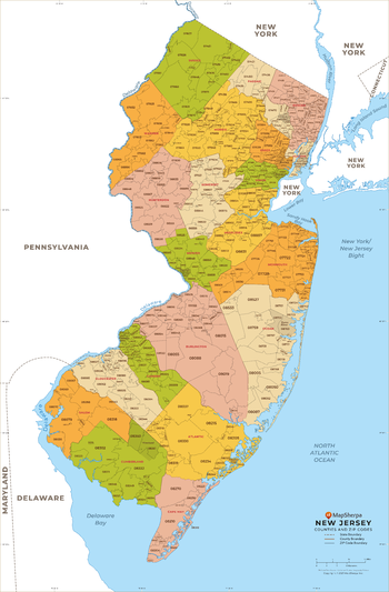
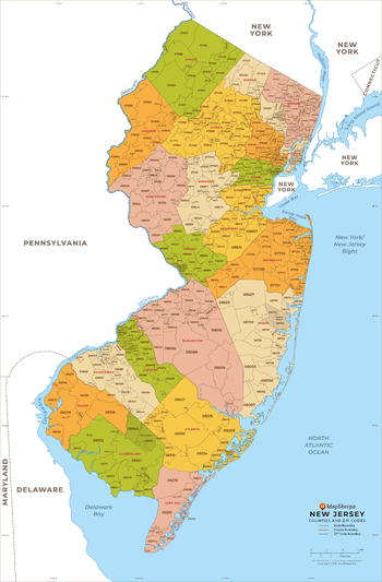
New Jersey ZIP Code Map with Counties - Extra Large
This map has been created exclusively for MapSherpa, and designed for business or reference use. Clear and clean colors & fonts matched with cartographic research makes this New Jersey Zip Code Map with Counties easily readable and useful. The map shows the 21 counties of New Jersey and the borders of the 759 zip codes across the Garden State.
Page Size: 60 x 91.5 in (1524 x 2321 mm)

New Jersey ZIP Code Map with Counties - Large
This map has been created exclusively for MapSherpa, and designed for business or reference use. Clear and clean colors & fonts matched with cartographic research makes this New Jersey Zip Code Map with Counties easily readable and useful. The map shows the 21 counties of New Jersey and the borders of the 759 zip codes across the Garden State.
Page Size: 48 x 73.25 in (1219 x 1857 mm)
New Jersey ZIP Code Map with Counties - Standard
This map has been created exclusively for MapSherpa, and designed for business or reference use. Clear and clean colors & fonts matched with cartographic research makes this New Jersey Zip Code Map with Counties easily readable and useful. The map shows the 21 counties of New Jersey and the borders of the 759 zip codes across the Garden State.
Page Size: 36 x 55 in (914 x 1392 mm)

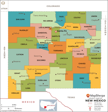
New Mexico Counties Map - Extra Large
This map has been created exclusively for MapSherpa, and designed for reference or business use. Clear and clean colors & fonts matched with cartographic research makes this map of the 33 New Mexico counties easily readable and useful.
Page Size: 60 x 62.5 in (1524 x 1586 mm)
New Mexico Counties Map - Large
This map has been created exclusively for MapSherpa, and designed for reference or business use. Clear and clean colors & fonts matched with cartographic research makes this map of the 33 New Mexico counties easily readable and useful.
Page Size: 48 x 50 in (1219 x 1269 mm)

New Mexico Counties Map - Standard
This map has been created exclusively for MapSherpa, and designed for reference or business use. Clear and clean colors & fonts matched with cartographic research makes this map of the 33 New Mexico counties easily readable and useful.
Page Size: 36 x 37.5 in (914 x 952 mm)
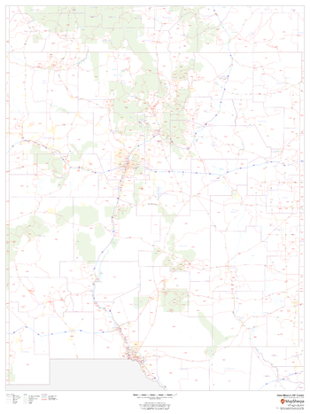
New Mexico ZIP Code Map
This map of New Mexico shows ZIP codes overlaid on a road map. Base map features include county boundaries, major road network features, and state and national parks and conservation areas.
Page Size: 36 x 48 in (914 x 1219 mm)