


MapSherpa
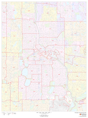
Minneapolis, Minnesota ZIP Codes
This map of Minneapolis, Minnesota shows ZIP code areas overlaid on a road map. Ideal for planning of deliveries, home services, sales territories, real estate and much more. Base map features include all roads with major roads and highways labelled; neighborhood names; railways; and high level land use such as parks and recreation areas, industrial areas and hospital campuses.
Page Size: 36 x 48 in (914 x 1219 mm)

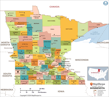
Minnesota Counties Map - Extra Large
This map has been created exclusively for MapSherpa, and designed for reference or business use. Clear and clean colors & fonts matched with cartographic research makes this map of the 87 Minnesota counties easily readable and useful.
Page Size: 60 x 53.75 in (1524 x 1360 mm)
Minnesota Counties Map - Large
This map has been created exclusively for MapSherpa, and designed for reference or business use. Clear and clean colors & fonts matched with cartographic research makes this map of the 87 Minnesota counties easily readable and useful.
Page Size: 48 x 43 in (1219 x 1088 mm)

Minnesota Counties Map - Standard
This map has been created exclusively for MapSherpa, and designed for reference or business use. Clear and clean colors & fonts matched with cartographic research makes this map of the 87 Minnesota counties easily readable and useful.
Page Size: 36 x 32.25 in (914 x 816 mm)
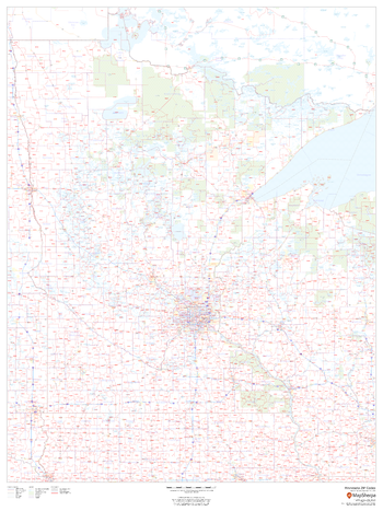
Minnesota ZIP Code Map
This map of Minnesota shows ZIP codes overlaid on a road map. Base map features include county boundaries, major road network features, and state and national parks and conservation areas.
Page Size: 36 x 48 in (914 x 1219 mm)

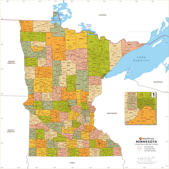
Minnesota ZIP Code Map with Counties - Extra Large
This map has been created exclusively for MapSherpa, and designed for business or reference use. Clear and clean colors & fonts matched with cartographic research makes this map of Minnesota's counties and ZIP codes easily readable and useful.
Page Size: 60 x 60 in (1524 x 1524 mm)

Minnesota ZIP Code Map with Counties - Large
This map has been created exclusively for MapSherpa, and designed for business or reference use. Clear and clean colors & fonts matched with cartographic research makes this map of Minnesota's counties and ZIP codes easily readable and useful.
Page Size: 48 x 48 in (1219 x 1219 mm)
Minnesota ZIP Code Map with Counties - Standard
This map has been created exclusively for MapSherpa, and designed for business or reference use. Clear and clean colors & fonts matched with cartographic research makes this map of Minnesota's counties and ZIP codes easily readable and useful.
Page Size: 36 x 36 in (914 x 914 mm)

Mississippi Counties Map - Extra Large
This map has been created exclusively for MapSherpa, and designed for reference or business use. Clear and clean colors & fonts matched with cartographic research makes this map of Mississippi Counties Map easily readable and useful. The map shows the 82 counties of Mississippi and their borders across the Magnolia State.
Page Size: 60 x 67.25 in (1524 x 1708 mm)
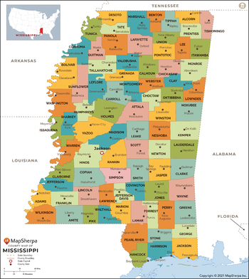
Mississippi Counties Map - Large
This map has been created exclusively for MapSherpa, and designed for reference or business use. Clear and clean colors & fonts matched with cartographic research makes this map of Mississippi Counties Map easily readable and useful. The map shows the 82 counties of Mississippi and their borders across the Magnolia State.
Page Size: 48 x 54 in (1219 x 1366 mm)

Mississippi Counties Map - Standard
This map has been created exclusively for MapSherpa, and designed for reference or business use. Clear and clean colors & fonts matched with cartographic research makes this map of Mississippi Counties Map easily readable and useful. The map shows the 82 counties of Mississippi and their borders across the Magnolia State.
Page Size: 36 x 40.5 in (914 x 1024 mm)
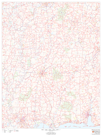
Mississippi ZIP Code Map
This map of Mississippi shows ZIP codes overlaid on a road map. Base map features include municipality and county boundaries, major road network features, and state and national parks and conservation areas.
Page Size: 36 x 48 in (914 x 1219 mm)

Mississippi ZIP Code Map with Counties - Extra Large
This map has been created exclusively for MapSherpa, and designed for business or reference use. Clear and clean colors & fonts matched with cartographic research makes this Mississippi Zip Code Map with Counties easily readable and useful. The map shows the 82 counties of Mississippi and the borders of the 423 zip codes across the Magnolia State.
Page Size: 60 x 86.25 in (1524 x 2185 mm)
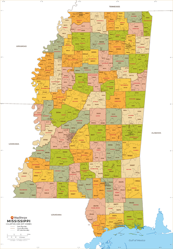
Mississippi ZIP Code Map with Counties - Large
This map has been created exclusively for MapSherpa, and designed for business or reference use. Clear and clean colors & fonts matched with cartographic research makes this Mississippi Zip Code Map with Counties easily readable and useful. The map shows the 82 counties of Mississippi and the borders of the 423 zip codes across the Magnolia State.
Page Size: 48 x 69 in (1219 x 1748 mm)

Mississippi ZIP Code Map with Counties - Standard
This map has been created exclusively for MapSherpa, and designed for business or reference use. Clear and clean colors & fonts matched with cartographic research makes this Mississippi Zip Code Map with Counties easily readable and useful. The map shows the 82 counties of Mississippi and the borders of the 423 zip codes across the Magnolia State.
Page Size: 36 x 51.75 in (914 x 1311 mm)
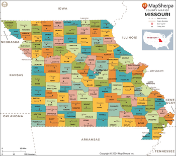
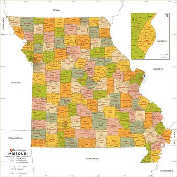
Missouri Counties Map - Extra Large
This map has been created exclusively for MapSherpa, and designed for reference or business use. Clear and clean colors & fonts matched with cartographic research makes this map of the 115 Missouri counties easily readable and useful.
Page Size: 60 x 53.25 in (1524 x 1351 mm)

Missouri Counties Map - Large
This map has been created exclusively for MapSherpa, and designed for reference or business use. Clear and clean colors & fonts matched with cartographic research makes this map of the 115 Missouri counties easily readable and useful.
Page Size: 48 x 42.75 in (1219 x 1081 mm)

Missouri Counties Map - Standard
This map has been created exclusively for MapSherpa, and designed for reference or business use. Clear and clean colors & fonts matched with cartographic research makes this map of the 115 Missouri counties easily readable and useful.
Page Size: 36 x 32 in (914 x 810 mm)
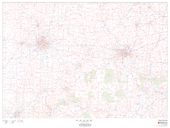
Missouri ZIP Code Map
This map of Missouri shows ZIP codes overlaid on a road map. Base map features include county boundaries, major road network features, and state and national parks and conservation areas.
Page Size: 48 x 36 in (1219 x 914 mm)
Missouri ZIP Code Map with Counties - Extra Large
This map has been created exclusively for MapSherpa, and designed for business or reference use. Clear and clean colors & fonts matched with cartographic research makes this map of Missouri's counties and ZIP codes easily readable and useful.
Page Size: 60 x 60 in (1524 x 1524 mm)