


MapSherpa
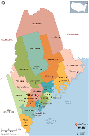
Maine Counties Map - Large
This map has been created exclusively for MapSherpa, and designed for reference or business use. Clear and clean colors & fonts matched with cartographic research makes this map of the 16 Maine counties easily readable and useful.
Page Size: 48 x 73 in (1219 x 1851 mm)

Maine Counties Map - Standard
This map has been created exclusively for MapSherpa, and designed for reference or business use. Clear and clean colors & fonts matched with cartographic research makes this map of the 16 Maine counties easily readable and useful.
Page Size: 36 x 54.75 in (914 x 1388 mm)
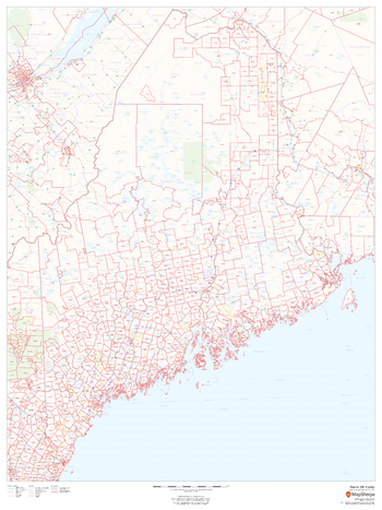
Maine ZIP Code Map
This map of Maine shows ZIP codes overlaid on a road map. Base map features include municipality and county boundaries, major road network features, and state and national parks and conservation areas.
Page Size: 36 x 48 in (914 x 1219 mm)

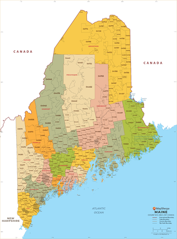
Maine ZIP Code Map with Counties - Extra Large
This map has been created exclusively for MapSherpa, and designed for business or reference use. Clear and clean colors & fonts matched with cartographic research makes this map of Maine's counties and ZIP codes easily readable and useful.
Page Size: 60 x 81 in (1524 x 2053 mm)
Maine ZIP Code Map with Counties - Large
This map has been created exclusively for MapSherpa, and designed for business or reference use. Clear and clean colors & fonts matched with cartographic research makes this map of Maine's counties and ZIP codes easily readable and useful.
Page Size: 48 x 64.75 in (1219 x 1642 mm)

Maine ZIP Code Map with Counties - Standard
This map has been created exclusively for MapSherpa, and designed for business or reference use. Clear and clean colors & fonts matched with cartographic research makes this map of Maine's counties and ZIP codes easily readable and useful.
Page Size: 36 x 48.5 in (914 x 1232 mm)
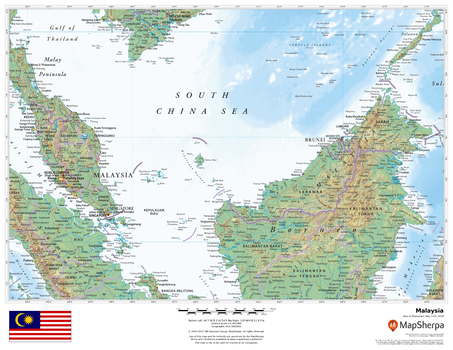
Malaysia
This beautiful map shows physical and political features for Malaysia and surrounding areas. Relief shading and the use of different colours by height above sea level are both informative and attractive.
Page Size: 22 x 17 in (559 x 432 mm)
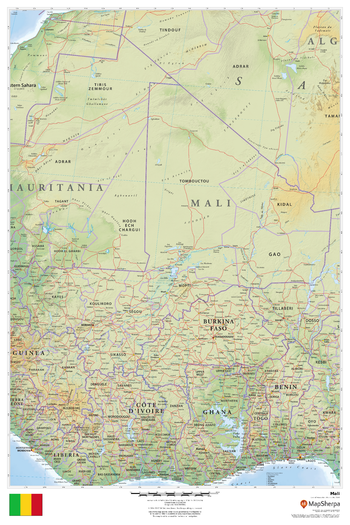
Mali
This beautiful map shows physical and political features for Mali and surrounding areas. Relief shading and the use of different colours by height above sea level are both informative and attractive.
Page Size: 24 x 36 in (610 x 914 mm)
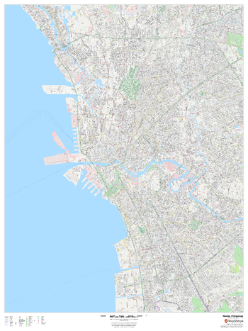
Manila, Philippines
This detailed street map of Manila, Philippines shows the full road and rail networks, points of interest, and land use across the city. Useful for businesses operating in the city, or as consumer memorabilia of the city.
Page Size: 36 x 48 in (914 x 1219 mm)
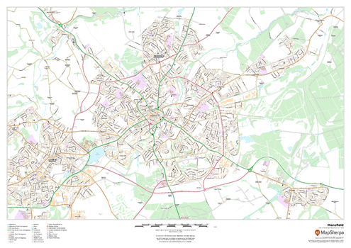
Mansfield
This map of Mansfield shows detailed street level information including extensive street labelling. Ideal for planning of deliveries, home services, sales territories, real estate and much more.
Page Size: 33.25 x 23.5 in (841 x 594 mm)
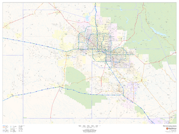
Maricopa County, Arizona
This map of Maricopa County, Arizona shows regional level information. Base map features include highways and major roads with labelling; high level land use such as parks and recreation areas; and a selection of points of interest including transportation hubs like airports and train stations, tourist information and police stations.
Page Size: 48 x 36 in (1219 x 914 mm)
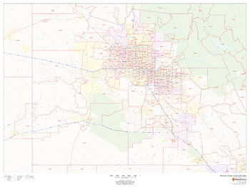
Maricopa County, Arizona ZIP Codes
This map of Maricopa County, Arizona shows ZIP code areas overlaid on a road map. Ideal for planning of deliveries, home services, sales territories, real estate and much more. Base map features include all roads with major roads and highways labelled; neighborhood names; and high level land use such as parks and recreation areas, industrial areas and hospital campuses.
Page Size: 48 x 36 in (1219 x 914 mm)
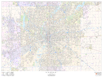
Marion County, Indiana
This map of Marion County, Indiana shows street level information including street labeling. Base map features include all roads with major roads and highways labelled; neighborhood names; railways; high level land use such as parks and recreation areas, industrial areas and hospital campuses; and a variety of points of interest including libraries, stadiums, museums, border crossings and more. ZIP code boundaries are shown as a secondary map feature.
Page Size: 48 x 36 in (1219 x 914 mm)
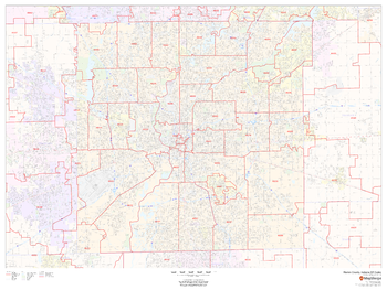
Marion County, Indiana ZIP Codes
This map of Marion County, Indiana shows ZIP code areas overlaid on a road map. Ideal for planning of deliveries, home ervices, sales territories, real estate and much more. Base map features include all roads with major roads and highways labelled; neighborhood names; railways; and high level land use such as parks and recreation areas, industrial areas and hospital campuses.
Page Size: 48 x 36 in (1219 x 914 mm)
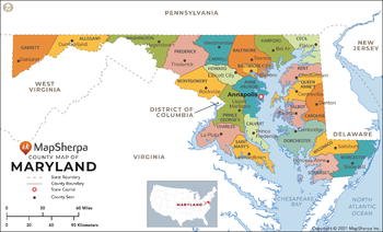
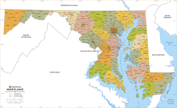
Maryland Counties Map - Extra Large
This map has been created exclusively for MapSherpa, and designed for reference or business use. Clear and clean colors & fonts matched with cartographic research makes this map of Maryland Counties Map easily readable and useful. The map shows the 64 counties of Maryland and their borders across the Old Line State.
Page Size: 60 x 36.5 in (1524 x 925 mm)

Maryland Counties Map - Large
This map has been created exclusively for MapSherpa, and designed for reference or business use. Clear and clean colors & fonts matched with cartographic research makes this map of Maryland Counties Map easily readable and useful. The map shows the 64 counties of Maryland and their borders across the Old Line State.
Page Size: 48 x 29.25 in (1219 x 740 mm)
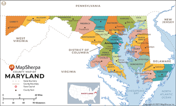
Maryland Counties Map - Standard
This map has been created exclusively for MapSherpa, and designed for reference or business use. Clear and clean colors & fonts matched with cartographic research makes this map of Maryland Counties Map easily readable and useful. The map shows the 64 counties of Maryland and their borders across the Old Line State.
Page Size: 36 x 22 in (914 x 555 mm)
Maryland ZIP Code Map
This map of Maryland shows ZIP codes overlaid on a road map. Base map features include municipality and county boundaries, major road network features, and state and national parks and conservation areas.
Page Size: 48 x 36 in (1219 x 914 mm)

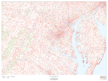
Maryland ZIP Code Map with Counties - Extra Large
This map has been created exclusively for MapSherpa, and designed for business or reference use. Clear and clean colors & fonts matched with cartographic research makes this Maryland Zip Code Map with Counties easily readable and useful. The map shows the 24 counties of Maryland and the borders of the 467 zip codes across the Old Line State.
Page Size: 60 x 37 in (1524 x 935 mm)
Maryland ZIP Code Map with Counties - Large
This map has been created exclusively for MapSherpa, and designed for business or reference use. Clear and clean colors & fonts matched with cartographic research makes this Maryland Zip Code Map with Counties easily readable and useful. The map shows the 24 counties of Maryland and the borders of the 467 zip codes across the Old Line State.
Page Size: 48 x 29.5 in (1219 x 748 mm)