


MapSherpa

Idaho ZIP Code Map with Counties - Extra Large
This map has been created exclusively for MapSherpa, and designed for business or reference use. Clear and clean colors & fonts matched with cartographic research makes this Idaho Zip Code Map with Counties easily readable and useful. The map shows the 44 counties of Idaho and the borders of the 278 zip codes across the Gem State.
Page Size: 60 x 81 in (1524 x 2052 mm)

Idaho ZIP Code Map with Counties - Large
This map has been created exclusively for MapSherpa, and designed for business or reference use. Clear and clean colors & fonts matched with cartographic research makes this Idaho Zip Code Map with Counties easily readable and useful. The map shows the 44 counties of Idaho and the borders of the 278 zip codes across the Gem State.
Page Size: 48 x 64.75 in (1219 x 1642 mm)
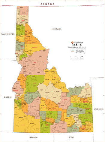
Idaho ZIP Code Map with Counties - Standard
This map has been created exclusively for MapSherpa, and designed for business or reference use. Clear and clean colors & fonts matched with cartographic research makes this Idaho Zip Code Map with Counties easily readable and useful. The map shows the 44 counties of Idaho and the borders of the 278 zip codes across the Gem State.
Page Size: 36 x 48.5 in (914 x 1231 mm)
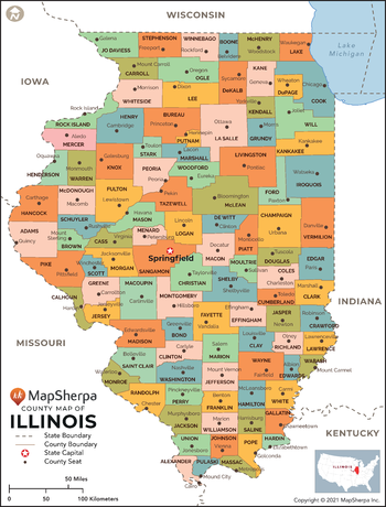
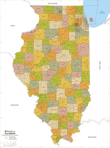
Illinois Counties Map - Extra Large
This map has been created exclusively for MapSherpa, and designed for reference or business use. Clear and clean colors & fonts matched with cartographic research makes this map of Illinois Counties Map easily readable and useful. The map shows the 102 counties of Illinois and their borders across the Land of Lincoln.
Page Size: 60 x 79 in (1524 x 2001 mm)

Illinois Counties Map - Large
This map has been created exclusively for MapSherpa, and designed for reference or business use. Clear and clean colors & fonts matched with cartographic research makes this map of Illinois Counties Map easily readable and useful. The map shows the 102 counties of Illinois and their borders across the Land of Lincoln.
Page Size: 48 x 63.25 in (1219 x 1601 mm)

Illinois Counties Map - Standard
This map has been created exclusively for MapSherpa, and designed for reference or business use. Clear and clean colors & fonts matched with cartographic research makes this map of Illinois Counties Map easily readable and useful. The map shows the 102 counties of Illinois and their borders across the Land of Lincoln.
Page Size: 36 x 47.5 in (914 x 1201 mm)
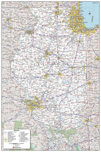
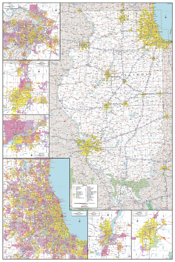
Illinois State Wall Map - Compact
This detailed wall map of Illinois is perfect for both educational and business purposes. The easy-to-read map features vibrant colors and clear labeling of cities, counties, highways, and geographical features. All national and state highways that connect the state are all clearly labelled on the map, while the legend notes the different road and land use classifications such as urban, park, military, and many more. The boundaries of each county in the state are defined and named clearly. Whether you are a student, teacher, business person or geography enthusiast, this map is a valuable addition to any space.
Page Size: 16 x 24 in (406 x 610 mm)
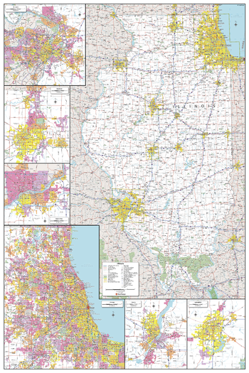
Illinois State Wall Map - Extra Large
This detailed wall map of Illinois is perfect for both educational and business purposes. The easy-to-read map features vibrant colors and clear labeling of cities, counties, highways, and geographical features. All national and state highways that connect the state are all clearly labelled on the map, while the legend notes the different road and land use classifications such as urban, park, military, and many more. The boundaries of each county in the state are defined and named clearly. Whether you are a student, teacher, business person or geography enthusiast, this map is a valuable addition to any space.
Page Size: 40 x 60 in (1016 x 1524 mm)
Illinois State Wall Map - Large
This detailed wall map of Illinois is perfect for both educational and business purposes. The easy-to-read map features vibrant colors and clear labeling of cities, counties, highways, and geographical features. All national and state highways that connect the state are all clearly labelled on the map, while the legend notes the different road and land use classifications such as urban, park, military, and many more. The boundaries of each county in the state are defined and named clearly. Whether you are a student, teacher, business person or geography enthusiast, this map is a valuable addition to any space.
Page Size: 32 x 48 in (813 x 1219 mm)

Illinois State Wall Map - Poster
This detailed wall map of Illinois is perfect for both educational and business purposes. The easy-to-read map features vibrant colors and clear labeling of cities, counties, highways, and geographical features. All national and state highways that connect the state are all clearly labelled on the map, while the legend notes the different road and land use classifications such as urban, park, military, and many more. The boundaries of each county in the state are defined and named clearly. Whether you are a student, teacher, business person or geography enthusiast, this map is a valuable addition to any space.
Page Size: 24 x 36 in (610 x 914 mm)
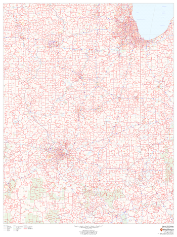
Illinois ZIP Code Map
This map of Illinois shows ZIP codes overlaid on a road map. Base map features include municipality and county boundaries, major road network features, and state and national parks and conservation areas.
Page Size: 36 x 48 in (914 x 1219 mm)

Illinois ZIP Code Map with Counties - Extra Large
This map has been created exclusively for MapSherpa, and designed for business or reference use. Clear and clean colors & fonts matched with cartographic research makes this Illinois Zip Code Map with Counties easily readable and useful. The map shows the 102 counties of Illinois and the borders of the over 1,500 zip codes across the Land of Lincoln.
Page Size: 60 x 81 in (1524 x 2053 mm)

Illinois ZIP Code Map with Counties - Large
This map has been created exclusively for MapSherpa, and designed for business or reference use. Clear and clean colors & fonts matched with cartographic research makes this Illinois Zip Code Map with Counties easily readable and useful. The map shows the 102 counties of Illinois and the borders of the over 1,500 zip codes across the Land of Lincoln.
Page Size: 48 x 64.75 in (1219 x 1642 mm)
Illinois ZIP Code Map with Counties - Standard
This map has been created exclusively for MapSherpa, and designed for business or reference use. Clear and clean colors & fonts matched with cartographic research makes this Illinois Zip Code Map with Counties easily readable and useful. The map shows the 102 counties of Illinois and the borders of the over 1,500 zip codes across the Land of Lincoln.
Page Size: 36 x 48.5 in (914 x 1232 mm)
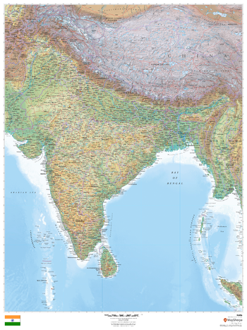
India
This beautiful map shows physical and political features for India and surrounding areas. Relief shading and the use of different colours by height above sea level are both informative and attractive.
Page Size: 36 x 48 in (914 x 1219 mm)

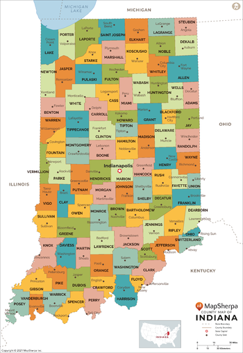
Indiana Counties Map - Extra Large
This map has been created exclusively for MapSherpa, and designed for reference or business use. Clear and clean colors & fonts matched with cartographic research makes this map of Indiana Counties Map easily readable and useful. The map shows the 92 counties of Indiana and their borders across the Hoosier State.
Page Size: 60 x 87.25 in (1524 x 2211 mm)
Indiana Counties Map - Large
This map has been created exclusively for MapSherpa, and designed for reference or business use. Clear and clean colors & fonts matched with cartographic research makes this map of Indiana Counties Map easily readable and useful. The map shows the 92 counties of Indiana and their borders across the Hoosier State.
Page Size: 48 x 69.75 in (1219 x 1769 mm)

Indiana Counties Map - Standard
This map has been created exclusively for MapSherpa, and designed for reference or business use. Clear and clean colors & fonts matched with cartographic research makes this map of Indiana Counties Map easily readable and useful. The map shows the 92 counties of Indiana and their borders across the Hoosier State.
Page Size: 36 x 52.25 in (914 x 1326 mm)
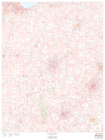
Indiana ZIP Code Map
This map of Indiana shows ZIP codes overlaid on a road map. Base map features include municipality and county boundaries, major road network features, and state and national parks and conservation areas.
Page Size: 36 x 48 in (914 x 1219 mm)
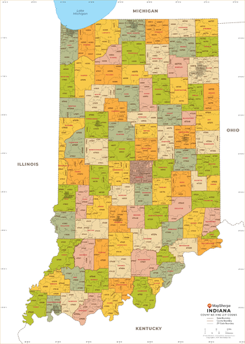
Indiana ZIP Code Map with Counties - Extra Large
This map has been created exclusively for MapSherpa, and designed for business or reference use. Clear and clean colors & fonts matched with cartographic research makes this Indiana Zip Code Map with Counties easily readable and useful. The map shows the 92 counties of Indiana and the borders of the 773 zip codes across the Hoosier State.
Page Size: 60 x 84.5 in (1524 x 2141 mm)