


MapSherpa
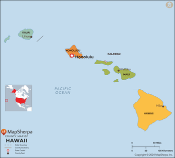
Hawaii Counties Map - Standard
This map has been created exclusively for MapSherpa, and designed for reference or business use. Clear and clean colors & fonts matched with cartographic research makes this map of the 5 Hawaii counties easily readable and useful.
Page Size: 36 x 32.5 in (914 x 824 mm)
Hawaii ZIP Code Map
This map of Hawaii shows ZIP codes overlaid on a road map. Base map features include municipality and county boundaries, major road network features, and state and national parks and conservation areas.
Page Size: 48 x 36 in (1219 x 914 mm)

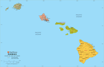
Hawaii ZIP Code Map with Counties - Extra Large
This map has been created exclusively for MapSherpa, and designed for business or reference use. Clear and clean colors & fonts matched with cartographic research makes this map of Hawaii's counties and ZIP codes easily readable and useful.
Page Size: 60 x 39.25 in (1524 x 995 mm)
Hawaii ZIP Code Map with Counties - Large
This map has been created exclusively for MapSherpa, and designed for business or reference use. Clear and clean colors & fonts matched with cartographic research makes this map of Hawaii's counties and ZIP codes easily readable and useful.
Page Size: 48 x 31.5 in (1219 x 796 mm)

Hawaii ZIP Code Map with Counties - Standard
This map has been created exclusively for MapSherpa, and designed for business or reference use. Clear and clean colors & fonts matched with cartographic research makes this map of Hawaii's counties and ZIP codes easily readable and useful.
Page Size: 36 x 23.75 in (914 x 597 mm)
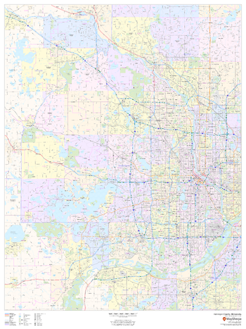
Hennepin County, Minnesota
This map of Hennepin County, Minnesota shows regional level information. Base map features include highways and major roads with labelling; neighborhood names; railways; high level land use such as parks and recreation areas, industrial areas and hospital campuses; and a selection of points of interest including transportation hubs like airports and train stations, tourist information, police stations and shopping centres. ZIP code boundaries are shown as a secondary map feature.
Page Size: 36 x 48 in (914 x 1219 mm)
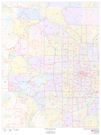
Hennepin County, Minnesota ZIP Codes
This map of Hennepin County, Minnesota shows ZIP code areas overlaid on a road map. Ideal for planning of deliveries, home services, sales territories, real estate and much more. Base map features include all roads with major roads and highways labelled; neighborhood names; railways; and high level land use such as parks and recreation areas, industrial areas and hospital campuses.
Page Size: 36 x 48 in (914 x 1219 mm)
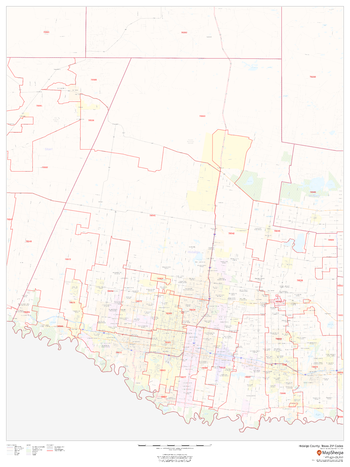
Hidalgo County, Texas
This map of Hidalgo County, Texas shows regional level information. Base map features include highways and major roads with labelling; neighborhood names; railways; high level land use such as parks and recreation areas, industrial areas and hospital campuses; and a selection of points of interest including transportation hubs like airports and train stations, tourist information, police stations and shopping centres. ZIP code boundaries are shown as a secondary map feature.
Page Size: 36 x 48 in (914 x 1219 mm)
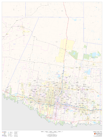
Hidalgo County, Texas ZIP Codes
This map of Hidalgo County, Texas shows ZIP code areas overlaid on a road map. Ideal for planning of deliveries, home ervices, sales territories, real estate and much more. Base map features include all roads with major roads and highways labelled; neighborhood names; railways; and high level land use such as parks and recreation areas, industrial areas and hospital campuses.
Page Size: 36 x 48 in (914 x 1219 mm)
Hillsborough County, Florida
This map of Hillsborough County, Florida shows regional level information. Base map features include highways and major roads with labelling; railways; high level land use such as parks and recreation areas; and a selection of points of interest including transportation hubs like airports and train stations, tourist information and police stations. ZIP code boundaries are shown as a secondary map feature.
Page Size: 48 x 36 in (1219 x 914 mm)
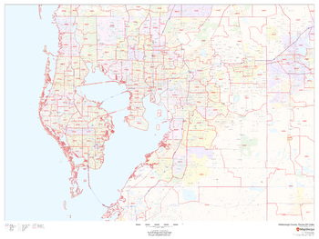
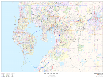
Hillsborough County, Florida ZIP Codes
This map of Hillsborough County, Florida shows ZIP code areas overlaid on a road map. Ideal for planning of deliveries, home services, sales territories, real estate and much more. Base map features include all roads with major roads and highways labelled; neighborhood names; railways; and high level land use such as parks and recreation areas, industrial areas and hospital campuses.
Page Size: 48 x 36 in (1219 x 914 mm)
Historic Aeronautical Charts
This multi-scale product is created from Tactical Pilotage Charts and Operational Navigational Charts. These topographic maps with aeronautical information provides coverage over the Mediterranean, Africa, the Middle East, and across the Himalayas to Japan. Individual map sheets have been combined into a seamless layer. and provide some of the most detailed mapping available for many remote parts of the world. Suitable for printing between 1:250,000 and 1:2,000,000.
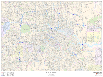
Houston, Texas Inner Metro - Landscape
This landscape-oriented map of central Houston, Texas shows detailed street level information including extensive street labeling. Ideal for planning of deliveries, home services, sales territories, real estate and much more. Base map features include all roads with major roads and highways labelled; neighborhood names; railways; high level land use such as parks and recreation areas, industrial areas and hospital campuses; and a variety of points of interest including schools, libraries, stadiums, museums, border crossings and more.
Page Size: 48 x 36 in (1219 x 914 mm)
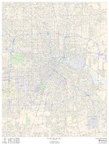
Houston, Texas Inner Metro - Portrait
This portrait-oriented map of central Houston, Texas shows detailed street level information including extensive street labeling. Ideal for planning of deliveries, home services, sales territories, real estate and much more. Base map features include all roads with major roads and highways labelled; neighborhood names; railways; high level land use such as parks and recreation areas, industrial areas and hospital campuses; and a variety of points of interest including schools, libraries, stadiums, museums, border crossings and more.
Page Size: 36 x 48 in (914 x 1219 mm)
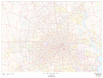
Houston, Texas ZIP Codes
This map of Houston shows ZIP code areas overlaid on a road map. Ideal for planning of deliveries, home services, sales territories, real estate and much more. Base map features include all roads with major roads and highways labelled; neighborhood names; railways; and high level land use such as parks and recreation areas, industrial areas and hospital campuses.
Page Size: 48 x 36 in (1219 x 914 mm)
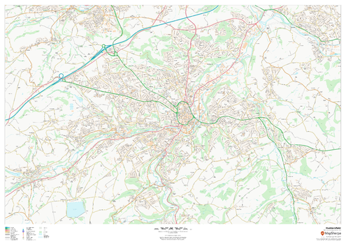
Huddersfield
This map of Huddersfield shows detailed street level information including extensive street labelling. Ideal for planning of deliveries, home services, sales territories, real estate and much more.
Page Size: 47 x 33.25 in (1189 x 841 mm)
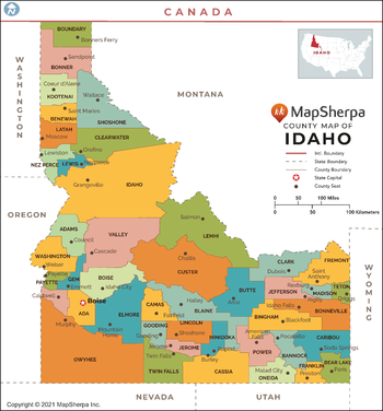
Idaho Counties Map - Extra Large
This map has been created exclusively for MapSherpa, and designed for reference or business use. Clear and clean colors & fonts matched with cartographic research makes this map of Idaho Counties Map easily readable and useful. The map shows the 44 counties of Idaho and their borders across the Gem State.
Page Size: 60 x 64.5 in (1524 x 1636 mm)

Idaho Counties Map - Large
This map has been created exclusively for MapSherpa, and designed for reference or business use. Clear and clean colors & fonts matched with cartographic research makes this map of Idaho Counties Map easily readable and useful. The map shows the 44 counties of Idaho and their borders across the Gem State.
Page Size: 48 x 51.75 in (1219 x 1308 mm)

Idaho Counties Map - Standard
This map has been created exclusively for MapSherpa, and designed for reference or business use. Clear and clean colors & fonts matched with cartographic research makes this map of Idaho Counties Map easily readable and useful. The map shows the 44 counties of Idaho and their borders across the Gem State.
Page Size: 36 x 38.75 in (914 x 981 mm)
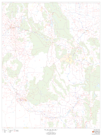
Idaho ZIP Code Map
This map of Idaho shows ZIP codes overlaid on a road map. Base map features include county boundaries, major road network features, and state and national parks and conservation areas.
Page Size: 36 x 48 in (914 x 1219 mm)