MapSherpa
Global Travel
Based on OpenStreetMap content; create city or regional scale maps for anywhere in the world. Maps feature a clean design and rich detail designed for the traveller to distant lands. Appropriate for mapping starting at 1:10,000 and up.
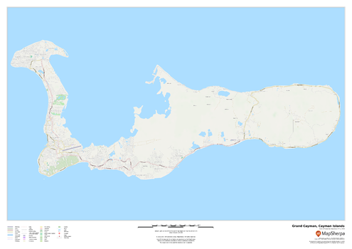
Grand Cayman, Cayman Islands
This map of Grand Cayman in the Cayman Islands features a full road network for the island including the capital George Town, walking paths, land use, points of interest, and many of the buildings. Useful for the traveller, and as a wall map for display in your home.
Page Size: 33.25 x 23.5 in (841 x 594 mm)
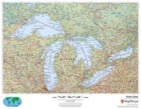
Great Lakes
This beautiful map shows physical and political features for the Great Lakes and surrounding areas. Relief shading and the use of different colours by height above sea level are both informative and attractive.
Page Size: 22 x 17 in (559 x 432 mm)
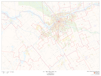
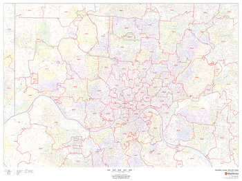
Greater Ottawa - Gatineau Postal Code Forward Sortation Areas
This map of Ottawa-Gatineau shows postal code forward sortation areas overlaid on a road map. Ideal for planning of deliveries, home services, sales territories, real estate and much more. Base map features include all roads with major roads and highways labelled; neighbourhood names; railways; and high level land use such as parks and recreation areas, industrial areas and hospital campuses.
Page Size: 48 x 36 in (1219 x 914 mm)
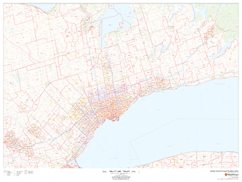
Greater Toronto Postal Code Forward Sortation Areas
This map of Greater Toronto shows postal code forward sortation areas overlaid on a road map. Ideal for planning of deliveries, home services, sales territories, real estate and much more. Base map features include all roads with major roads and highways labelled; neighbourhood names; railways; and high level land use such as parks and recreation areas and industrial areas.
Page Size: 48 x 36 in (1219 x 914 mm)
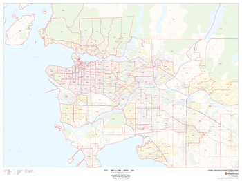
Greater Vancouver Postal Code Forward Sortation Areas
This map of Greater Vancouver shows postal code forward sortation areas overlaid on a road map. Ideal for planning of deliveries, home services, sales territories, real estate and much more. Base map features include all roads with major roads and highways labelled; neighbourhood names; railways; and high level land use such as parks and recreation areas, industrial areas and hospital campuses.
Page Size: 48 x 36 in (1219 x 914 mm)
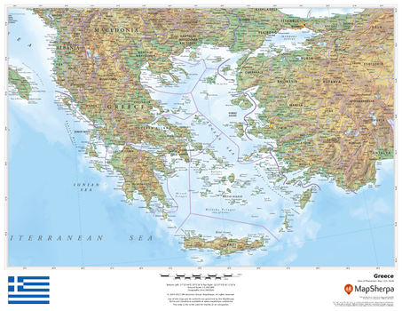
Greece
This beautiful map shows physical and political features for Greece and surrounding areas. Relief shading and the use of different colours by height above sea level are both informative and attractive.
Page Size: 22 x 17 in (559 x 432 mm)
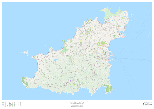
Guernsey - Channel Islands
This wall map of Guernsey in the Channel Islands showcases a full road network of the island, including within Saint Peter Port. Parks, walking and bicycle paths, many buildings, and point of interest are displayed.
Page Size: 47 x 33.25 in (1189 x 841 mm)
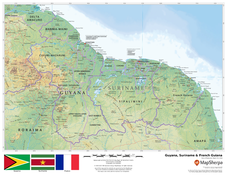
Guyana, Surinam & French Guiana
This beautiful map shows physical and political features for Guyana, Surinam, French Guiana and surrounding areas. Relief shading and the use of different colours by height above sea level are both informative and attractive.
Page Size: 22 x 17 in (559 x 432 mm)
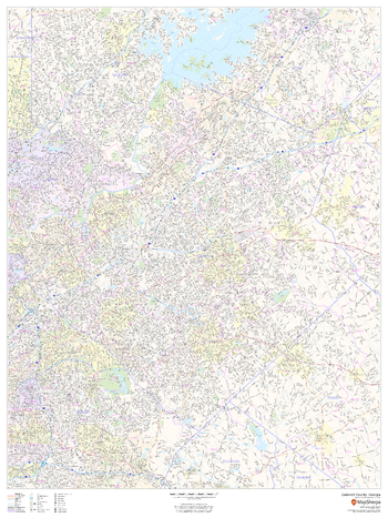
Gwinnett County, Georgia
This map of Gwinnett County, Georgia shows regional level information. Base map features include highways and major roads with labelling; neighborhood names; railways; high level land use such as parks and recreation areas, industrial areas and hospital campuses; and a selection of points of interest including transportation hubs like airports and train stations, tourist information, police stations and shopping centres. ZIP code boundaries are shown as a secondary map feature.
Page Size: 36 x 48 in (914 x 1219 mm)
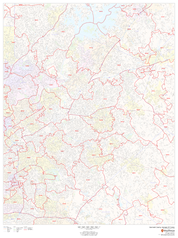
Gwinnett County, Georgia ZIP Codes
This map of Gwinnett County, Georgia shows ZIP code areas overlaid on a road map. Ideal for planning of deliveries, home ervices, sales territories, real estate and much more. Base map features include all roads with major roads and highways labelled; neighborhood names; railways; and high level land use such as parks and recreation areas, industrial areas and hospital campuses.
Page Size: 36 x 48 in (914 x 1219 mm)
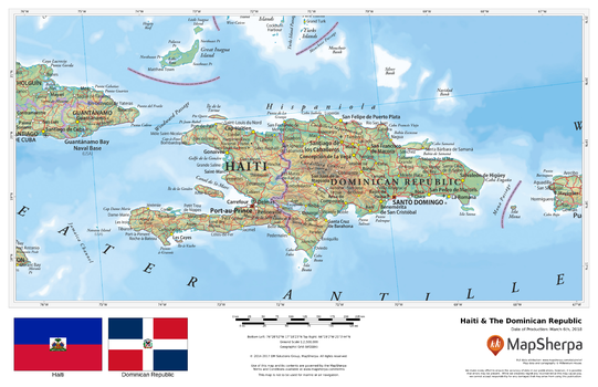
Haiti & The Dominican Republic
This beautiful map shows physical and political features for Haiti, the Dominican Republic, and surrounding areas. Relief shading and the use of different colours by height above sea level are both informative and attractive.
Page Size: 17 x 11 in (432 x 279 mm)
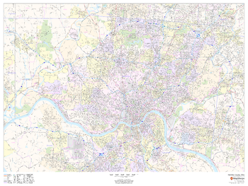
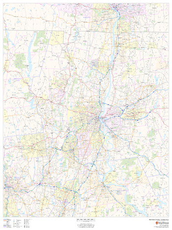
Hamilton County, Ohio
This map of Hamilton County, Ohio shows street level information including street labeling. Base map features include all roads with major roads and highways labelled; neighborhood names; railways; high level land use such as parks and recreation areas, industrial areas and hospital campuses; and a variety of points of interest including libraries, stadiums, museums, border crossings and more. ZIP code boundaries are shown as a secondary map feature.
Page Size: 48 x 36 in (1219 x 914 mm)
Hamilton County, Ohio ZIP Codes
This map of Hamilton County, Ohio shows ZIP code areas overlaid on a road map. Ideal for planning of deliveries, home ervices, sales territories, real estate and much more. Base map features include all roads with major roads and highways labelled; neighborhood names; railways; and high level land use such as parks and recreation areas, industrial areas and hospital campuses.
Page Size: 48 x 36 in (1219 x 914 mm)
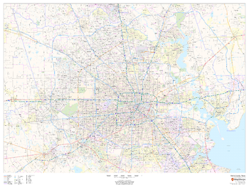
Harris County, Texas
This map of Harris County, Texas shows regional level information. Base map features include highways and major roads with labelling; railways; high level land use such as parks and recreation areas; and a selection of points of interest including transportation hubs like airports and train stations, tourist information and police stations. ZIP code boundaries are shown as a secondary map feature.
Page Size: 48 x 36 in (1219 x 914 mm)
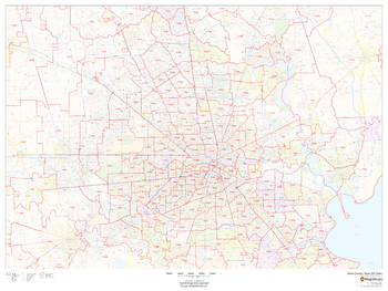
Harris County, Texas ZIP Codes
This map of Harris County, Texas shows ZIP code areas overlaid on a road map. Ideal for planning of deliveries, home services, sales territories, real estate and much more. Base map features include all roads with major roads and highways labelled; neighborhood names; railways; and high level land use such as parks and recreation areas, industrial areas and hospital campuses.
Page Size: 48 x 36 in (1219 x 914 mm)
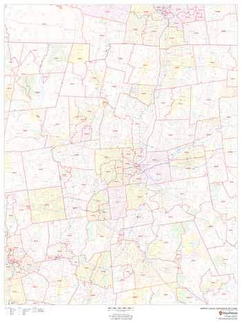
Hartford County, Connecticut
This map of Hartford County, Connecticut regional level information. Base map features include highways and major roads with labelling; neighborhood names; railways; high level land use such as parks and recreation areas, industrial areas and hospital campuses; and a selection of points of interest including transportation hubs like airports and train stations, tourist information, police stations and shopping centres. ZIP code boundaries are shown as a secondary map feature.
Page Size: 36 x 48 in (914 x 1219 mm)
Hartford County, Connecticut ZIP Codes
This map of Hartford County, Connecticut shows ZIP code areas overlaid on a road map. Ideal for planning of deliveries, home ervices, sales territories, real estate and much more. Base map features include all roads with major roads and highways labelled; neighborhood names; railways; and high level land use such as parks and recreation areas, industrial areas and hospital campuses.
Page Size: 36 x 48 in (914 x 1219 mm)

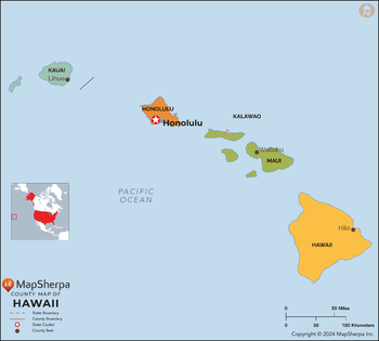
Hawaii Counties Map - Extra Large
This map has been created exclusively for MapSherpa, and designed for reference or business use. Clear and clean colors & fonts matched with cartographic research makes this map of the 5 Hawaii counties easily readable and useful.
Page Size: 60 x 54.25 in (1524 x 1373 mm)
Hawaii Counties Map - Large
This map has been created exclusively for MapSherpa, and designed for reference or business use. Clear and clean colors & fonts matched with cartographic research makes this map of the 5 Hawaii counties easily readable and useful.
Page Size: 48 x 43.25 in (1219 x 1098 mm)