Lucidmap
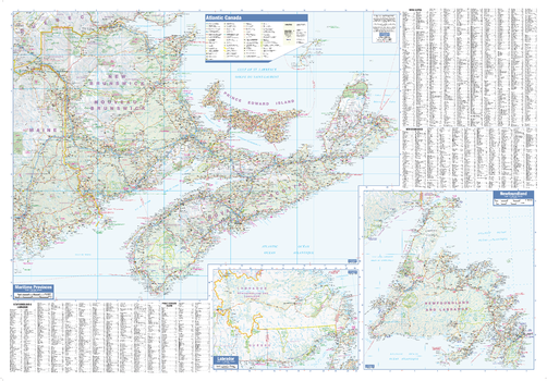
Maritimes Wall Map - Large
This large wall map has been designed to show important features in Canada's atlantic provinces. This includes all highways, cities and towns, major parks, political boundaries, and points of interest.
The map has been designed with a traditional Canadian style embraced by map buyers over many years. It also includes a helpful place name index.
Page Size: 54 x 37.5 in (1372 x 953 mm)
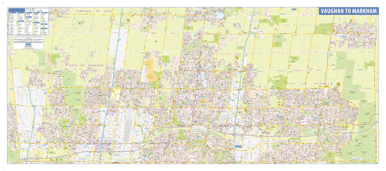
Markham-Vaughan Wall Map - Street Detail
This wall map shows highly detailed local information for the Region of York. Full street labeling along with transit information, parks, schools, churches and landmarks throughout the city are displayed.
The map has been designed in a very clear and legible manner with a traditional Canadian street map style embraced by map buyers over many years.
Page Size: 53 x 23 in (1346 x 584 mm)
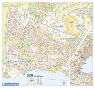
Mississauga Wall Map - Large
This wall map shows highly detailed local information of the city of Mississauga. Full street labeling along with transit information, parks, schools, churches and landmarks throughout the city are displayed.
The map has been designed in a very clear and legible manner with a traditional Canadian street map style embraced by map buyers over many years.
Page Size: 38.5 x 35.5 in (975 x 900 mm)
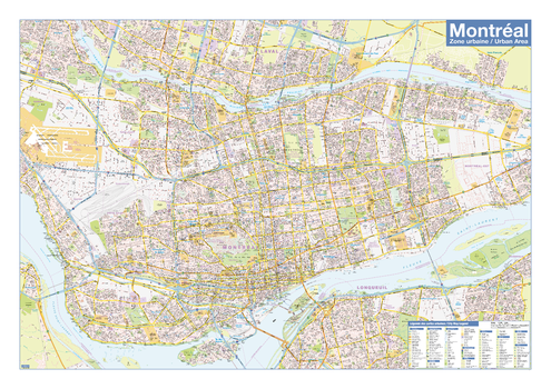
Montreal
Create custom street maps in Montreal centred on your business, home or other key point of interest. Maps are developed from Lucidmap’s iconic Canadian street mapping cartography. Coverage includes most of Greater Montreal. The northern coverage limit includes, from east to west, Lavaltrie, Haut l'Assomption, L'Épiphanie, La Plaine, Saint-Janvier, Saint-Augustin, La Fresnière, Saint-Joseph-du-lac, Oka, Husdon and Saint-Polycarpe. The southern coverage limit includes, from east to west, Contrecour, Verchères, Beloeil, Chambly, Saint-Philippe, northern St-Rémi, Mercier and Saint-Louis-de-Gonzague. Native scale is 1:25,000.
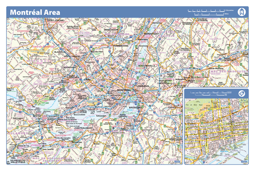
Montreal Area - Compact
Map of the Montreal area showing major roads, major road names, political boundaries, major points of interest, parks, public buildings and landmarks.
Page Size: 21.5 x 14.25 in (546 x 362 mm)
Montreal Downtown
Map of downtown Montreal showing all roads, road names, political boundaries, transit, points of interest, parks, schools, churches, public buildings and landmarks.
Page Size: 40 x 28 in (1016 x 711 mm)
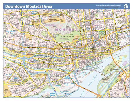
Montreal Downtown - Compact
Map of downtown Montreal showing all roads, road names, political boundaries, transit, points of interest, parks, schools, churches, public buildings and landmarks.
Page Size: 21.5 x 16.25 in (546 x 413 mm)

Montreal French Downtown - Compact (French Version)
Map of downtown Montreal in French showing all roads, road names, political boundaries, transit, points of interest, parks, schools, churches, public buildings and landmarks.
Page Size: 21.5 x 16.25 in (546 x 413 mm)
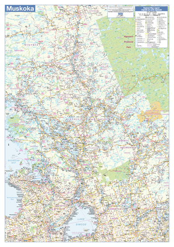
Muskoka Wall Map - Road Map
This wall map has been designed to show the Muskoka area of Ontario including all highways, cities and towns, major parks, political boundaries, and points of interest.
The map has been designed with a traditional Canadian style embraced by map buyers over many years.
Page Size: 28 x 40 in (711 x 1016 mm)
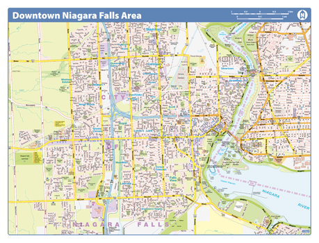
Niagara Falls Downtown - Compact
Map of downtown Niagara Falls showing all roads, road names, political boundaries, transit, points of interest, parks, schools, churches, public buildings and landmarks.
Page Size: 21.5 x 16.25 in (546 x 413 mm)
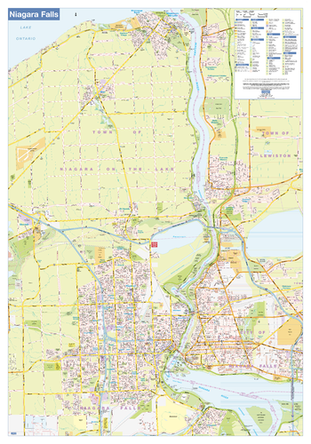
Niagara Falls Wall Map - Street Detail
This wall map shows highly detailed local information for the city of Niagara Falls. Full street labeling along with transit information, parks, schools, churches and landmarks throughout the city are displayed.
The map has been designed in a very clear and legible manner with a traditional Canadian street map style embraced by map buyers over many years.
Page Size: 37.5 x 54 in (953 x 1372 mm)
Northern Alberta
Create custom regional maps in Canada from this series of attractive detailed road maps covering most of the populated areas across Canada. Maps are developed from Lucidmap’s iconic Canadian cartography. Coverage of northern Alberta includes Wood Buffalo National Part in the north-east corner of the map area, Cold Lake Air Weapons Range in the south-east corner, Pine Le Moray Provincial Park in the south-west corner, and Thinahtea North Provincial Protected Area in the north-west corner. Communities in the coverage area include Grand Prairie, Peace River, Dawson Creek, Fort St. John, Fort McMurray and Fort Vermillion. Native scale is 1:500,000.
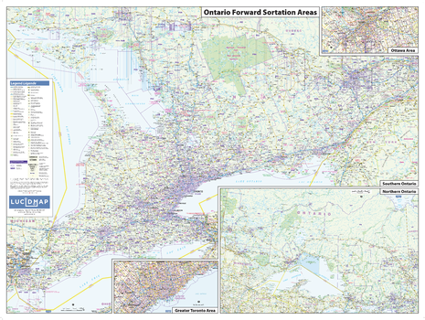
Ontario Postcode (FSAs) Wall Map - Large
This Postcode Wall Map of Ontario shows forward sortation areas, political boundaries, place names, highways, major parks and conservation areas, and points of interest.
The map has been designed in a very clear and legible manner with a traditional Canadian street map style embraced by map buyers over many years.
Page Size: 50 x 37.5 in (1270 x 953 mm)
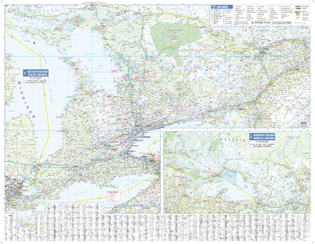
Ontario Wall Map - South Portion with Northern Ontario Inset
This wall map has been designed to show details of the populated areas of Ontario including all highways, cities and towns, major parks, political boundaries, and points of interest.
The map has been designed with a traditional Canadian style embraced by map buyers over many years.
Page Size: 39.5 x 30.5 in (1003 x 775 mm)
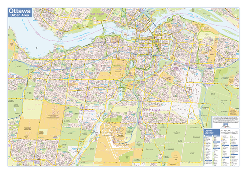
Ottawa Area - Compact
Map of the Ottawa area showing major roads, major road names, political boundaries, major points of interest, parks, public buildings and landmarks.
Page Size: 21.5 x 14.25 in (546 x 362 mm)
Ottawa Downtown
Map of downtown Ottawa showing all roads, road names, political boundaries, transit, points of interest, parks, schools, churches, public buildings and landmarks.
Page Size: 40 x 28 in (1016 x 711 mm)
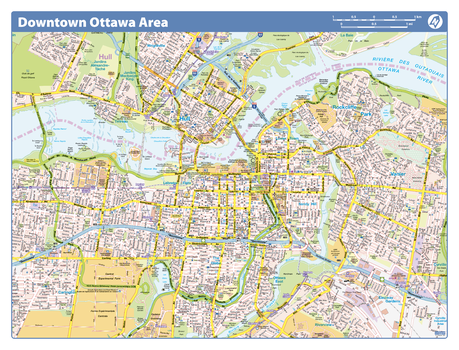
Ottawa Downtown - Compact
Map of downtown Ottawa showing all roads, road names, political boundaries, transit, points of interest, parks, schools, churches, public buildings and landmarks.
Page Size: 21.5 x 16.25 in (546 x 413 mm)
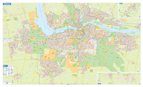
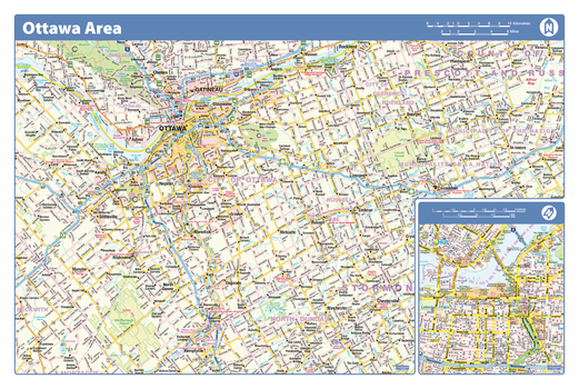
Ottawa-Gatineau Wall Map - Street Detail - Extra Large
This wall map of the Ottawa-Gatineau Area shows highly detailed local information of the city of Ottawa, city of Gatineau and the surrounding areas. Full street labeling along with transit information, parks, schools, churches and landmarks throughout the city are displayed.
The map has been designed in a very clear and legible manner with a traditional Canadian street map style embraced by map buyers over many years.
Page Size: 79 x 48 in (2007 x 1219 mm)
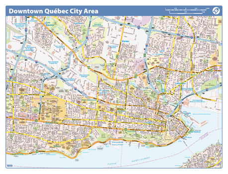
Quebec City Downtown - Compact
Map of downtown Quebec City showing all roads, road names, political boundaries, transit, points of interest, parks, schools, churches, public buildings and landmarks.
Page Size: 21.5 x 16.25 in (546 x 413 mm)
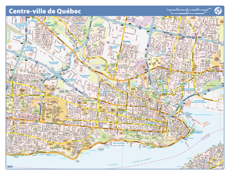
Quebec City Downtown - Compact (French Version)
Map of downtown Quebec City in French showing all roads, road names, political boundaries, transit, points of interest, parks, schools, churches, public buildings and landmarks.
Page Size: 21.5 x 16.25 in (546 x 413 mm)