Lucidmap
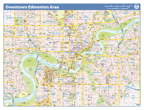
Edmonton Downtown
Map of downtown Edmonton showing all roads, road names, political boundaries, transit, points of interest, parks, schools, churches, public buildings and landmarks.
Page Size: 28 x 40 in (711 x 1016 mm)
Edmonton Downtown - Compact
Map of downtown Edmonton showing all roads, road names, political boundaries, transit, points of interest, parks, schools, churches, public buildings and landmarks.
Page Size: 21.5 x 16.25 in (546 x 413 mm)
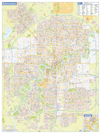
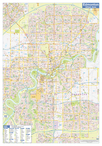
Edmonton Wall Map - Street Detail - Large
This large wall map shows highly detailed local information for the city of Edmonton. Full street labeling along with transit information, parks, schools, churches and landmarks throughout the city are displayed.
The map has been designed in a very clear and legible manner with a traditional Canadian street map style embraced by map buyers over many years.
Page Size: 37 x 49 in (940 x 1245 mm)
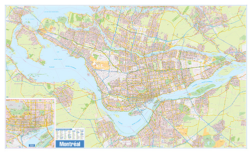
Greater Montreal Wall Map - Street Detail - Extra Large
This wall map of the Greater Montreal Area shows highly detailed local information for the city of Montreal and the surrounding area. Full street labeling along with transit information, parks, schools, churches and landmarks throughout the city are displayed.
The map has been designed in a very clear and legible manner with a traditional Canadian street map style embraced by map buyers over many years.
Page Size: 79 x 48 in (2007 x 1219 mm)
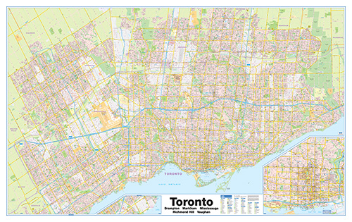
Greater Toronto Wall Map - Street Detail - Extra Large
This wall map of the Greater Toronto Area shows highly detailed local information for the city of Toronto and the surrounding area. Full street labeling along with transit information, parks, schools, churches and landmarks throughout the city are displayed.
The map has been designed in a very clear and legible manner with a traditional Canadian street map style embraced by map buyers over many years.
Page Size: 80 x 50 in (2032 x 1270 mm)
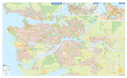
Greater Vancouver Wall Map - Street Detail - Extra Large
This wall map of the Greater Vacouver Area shows highly detailed local information for the city of Vancouver and the surrounding area. Full street labeling along with transit information, parks, schools, churches and landmarks throughout the city are displayed.
The map has been designed in a very clear and legible manner with a traditional Canadian street map style embraced by map buyers over many years.
Page Size: 79 x 48 in (2007 x 1219 mm)
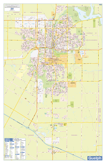
Guelph Wall Map - Street Detail
This wall map shows highly detailed local information for the city of Guelph. Full street labeling along with transit information, parks, schools, churches and landmarks throughout the city are displayed.
The map has been designed in a very clear and legible manner with a traditional Canadian street map style embraced by map buyers over many years.
Page Size: 28 x 44 in (711 x 1118 mm)
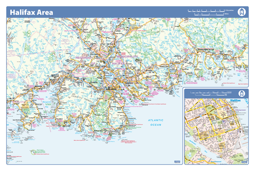
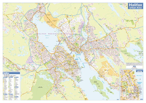
Halifax Area - Compact
Map of the Halifax area showing major roads, major road names, political boundaries, major points of interest, parks, public buildings and landmarks.
Page Size: 21.5 x 14.25 in (546 x 362 mm)
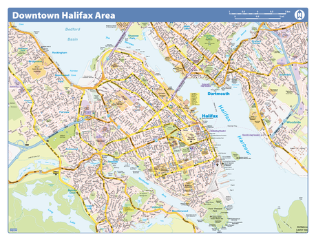
Halifax Downtown
Map of downtown Halifax showing all roads, road names, political boundaries, transit, points of interest, parks, schools, churches, public buildings and landmarks.
Page Size: 40 x 28 in (1016 x 711 mm)
Halifax Downtown - Compact
Map of downtown Halifax showing all roads, road names, political boundaries, transit, points of interest, parks, schools, churches, public buildings and landmarks.
Page Size: 21.5 x 16.25 in (546 x 413 mm)
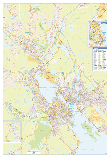
Halifax Wall Map - Street Detail - Large
This large wall map shows highly detailed local information for the city of Halifax. Full street labeling along with transit information, parks, schools, churches and landmarks throughout the city are displayed.
The map has been designed in a very clear and legible manner with a traditional Canadian street map style embraced by map buyers over many years.
Page Size: 37 x 53.25 in (938 x 1350 mm)
Halton Wall Map - Street Detail
This wall map shows highly detailed local information for the Region of Halton. Full street labeling along with transit information, parks, schools, churches and landmarks throughout the city are displayed.
The map has been designed in a very clear and legible manner with a traditional Canadian street map style embraced by map buyers over many years.
Page Size: 51 x 23 in (1295 x 584 mm)
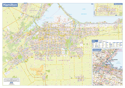
Hamilton Wall Map - Street Detail
This wall map shows highly detailed local information for the city of Hamilton. Full street labeling along with transit information, parks, schools, churches and landmarks throughout the city are displayed.
The map has been designed in a very clear and legible manner with a traditional Canadian street map style embraced by map buyers over many years.
Page Size: 40 x 28 in (1016 x 711 mm)
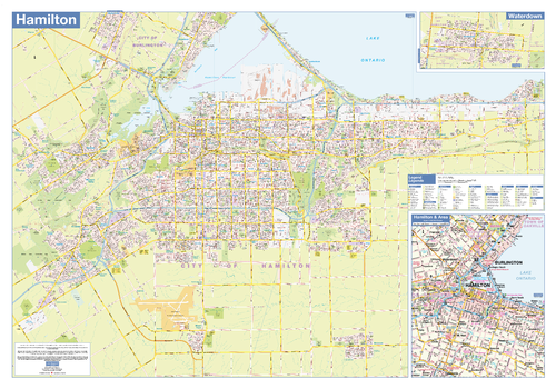
Hamilton Wall Map - Street Detail - Large
This large wall map shows highly detailed local information of the city of Hamilton. Full street labeling along with transit information, parks, schools, churches and landmarks throughout the city are displayed.
The map has been designed in a very clear and legible manner with a traditional Canadian street map style embraced by map buyers over many years.
Page Size: 54 x 37.5 in (1372 x 953 mm)
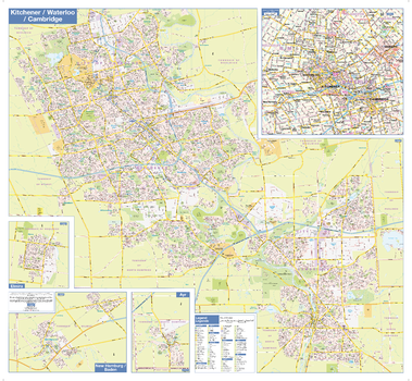
Kitchener Waterloo Cambridge Wall Map - Street Detail
This Kitchener Waterloo Cambridge wall map shows highly detailed local information for the Tri-Cities metropolitain area. Full street labeling along with transit information, parks, schools, churches and landmarks throughout the city are displayed.
The map has been designed in a very clear and legible manner with a traditional Canadian street map style embraced by map buyers over many years.
Page Size: 38.5 x 35.5 in (975 x 900 mm)
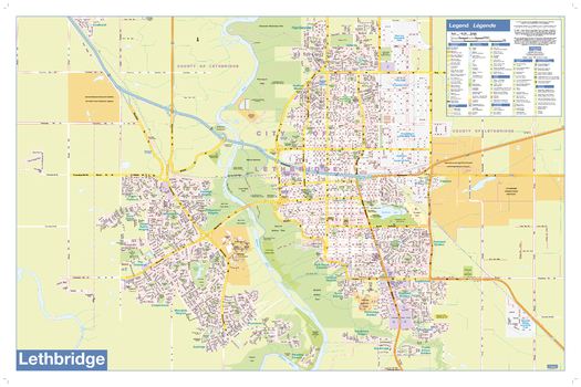
Lethbridge Wall Map - Street Detail
This wall map shows highly detailed local information for the city of Lethbridge. Full street labeling along with transit information, parks, schools, churches and landmarks throughout the city are displayed.
The map has been designed in a very clear and legible manner with a traditional Canadian street map style embraced by map buyers over many years.
Page Size: 35 x 23 in (889 x 584 mm)
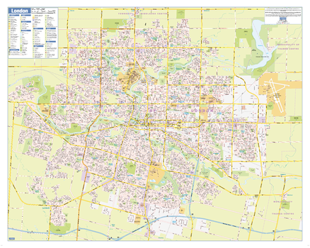
London Ontario Wall Map - Street Detail
This wall map shows highly detailed local information for the city of London. Full street labeling along with transit information, parks, schools, churches and landmarks throughout the city are displayed.
The map has been designed in a very clear and legible manner with a traditional Canadian street map style embraced by map buyers over many years.
Page Size: 34.5 x 27.5 in (870 x 696 mm)
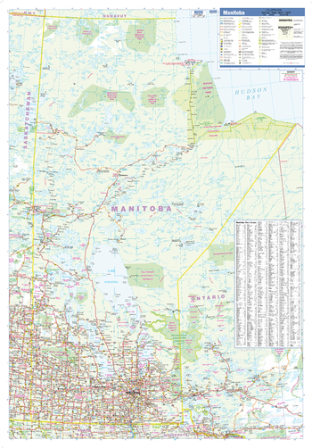
Manitoba Wall Map
This wall map has been designed to show important features in Manitoba including all highways, cities and towns, major parks, political boundaries, and points of interest.
The map has been designed with a traditional Canadian style embraced by map buyers over many years.
Page Size: 28 x 40 in (711 x 1016 mm)
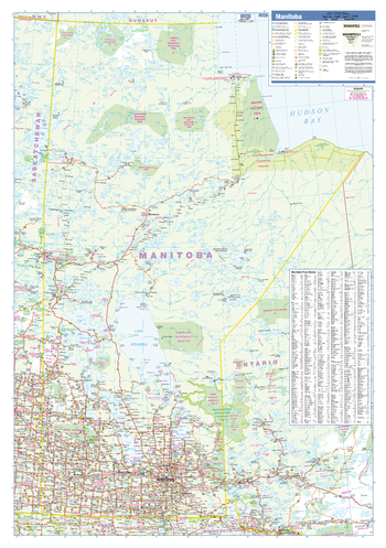
Manitoba Wall Map - Large
This large wall map has been designed to show important features in Manitoba including all highways, cities and towns, major parks, political boundaries, and points of interest.
The map has been designed with a traditional Canadian style embraced by map buyers over many years.
Page Size: 37.5 x 54 in (953 x 1372 mm)
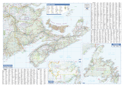
Maritimes Wall Map
This wall map has been designed to show important features in Canada's atlantic provinces. This includes all highways, cities and towns, major parks, political boundaries, and points of interest.
The map has been designed with a traditional Canadian style embraced by map buyers over many years. It also includes a helpful place name index.
Page Size: 40 x 28 in (1016 x 711 mm)