Lucidmap
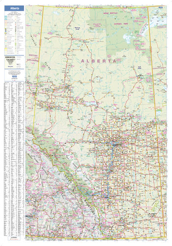
Alberta Wall Map
This wall map has been designed to show important features in Alberta, including all highways, cities and towns, major parks, political boundaries, and points of interest.
The map has been designed with a traditional Canadian style embraced by map buyers over many years.
Page Size: 28 x 40 in (711 x 1016 mm)
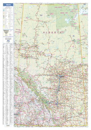
Alberta Wall Map - Large
This large wall map has been designed to show important features in Alberta, including all highways, cities and towns, major parks, political boundaries, and points of interest.
The map has been designed with a traditional Canadian style embraced by map buyers over many years.
Page Size: 37.5 x 54 in (953 x 1372 mm)
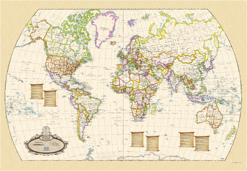
Antique World Wall Map - English and French
This world wall map has been designed with all text in both French and English, making this an ideal product in Canada for schools, businesses and public areas.
The map has been designed in an antique style that makes for classy and visually appealing wall art.
Page Size: 39.5 x 27.25 in (1003 x 692 mm)
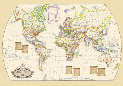
Antique World Wall Map - English and French - Large
This large world wall map has been designed with all text in both French and English, making this an ideal product in Canada for schools, businesses and public areas.
The map has been designed in an antique style that makes for classy and visually appealing wall art.
Page Size: 54 x 37.5 in (1372 x 953 mm)
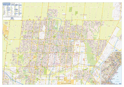
Brampton Wall Map - Street Detail
This wall map shows highly detailed local information for the city of Brampton. Full street labeling along with transit information, parks, schools, churches and landmarks throughout the city are displayed.
The map has been designed in a very clear and legible manner with a traditional Canadian street map style embraced by map buyers over many years.
Page Size: 40 x 28 in (1016 x 711 mm)
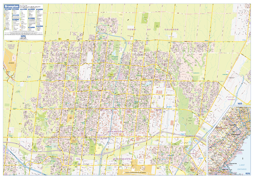
Brampton Wall Map - Street Detail - Large
This large wall map shows highly detailed local information for the city of Brampton. Full street labeling along with transit information, parks, schools, churches and landmarks throughout the city are displayed.
The map has been designed in a very clear and legible manner with a traditional Canadian street map style embraced by map buyers over many years.
Page Size: 54 x 37.5 in (1372 x 953 mm)
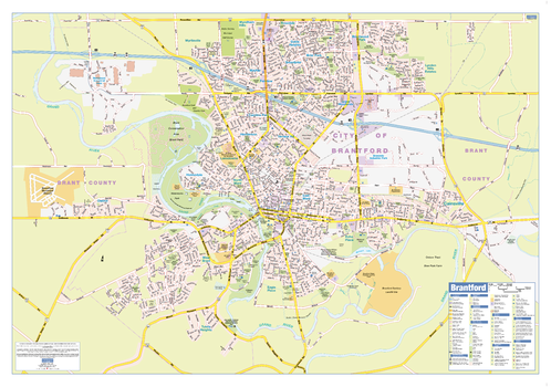
Brantford Wall Map - Street Detail
This wall map shows highly detailed local information for the city of Brantford. Full street labeling along with transit information, parks, schools, churches and landmarks throughout the city are displayed.
The map has been designed in a very clear and legible manner with a traditional Canadian street map style embraced by map buyers over many years.
Page Size: 36.5 x 25.5 in (925 x 642 mm)
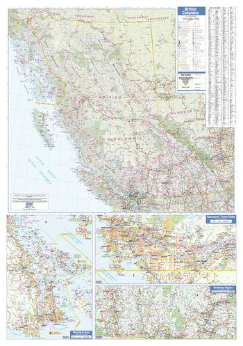
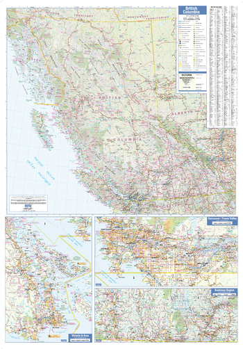
British Columbia Wall Map
This wall map has been designed to show important features in British Columbia, including all highways, cities and towns, major parks, political boundaries, and points of interest.
The map has been designed with a traditional Canadian style embraced by map buyers over many years.
Page Size: 28 x 40 in (711 x 1016 mm)
British Columbia Wall Map - Large
This large wall map has been designed to show important features in British Columbia, including all highways, cities and towns, major parks, political boundaries, and points of interest.
The map has been designed with a traditional Canadian style embraced by map buyers over many years.
Page Size: 37.5 x 54 in (953 x 1372 mm)
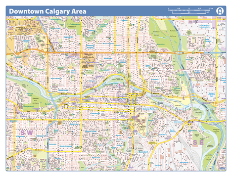
Calgary Downtown
Map of downtown Calgary showing all roads, road names, political boundaries, transit, points of interest, parks, schools, churches, public buildings and landmarks.
Page Size: 28 x 40 in (711 x 1016 mm)
Calgary Downtown - Compact
Map of downtown Calgary showing all roads, road names, political boundaries, transit, points of interest, parks, schools, churches, public buildings and landmarks.
Page Size: 21.5 x 16.25 in (546 x 413 mm)
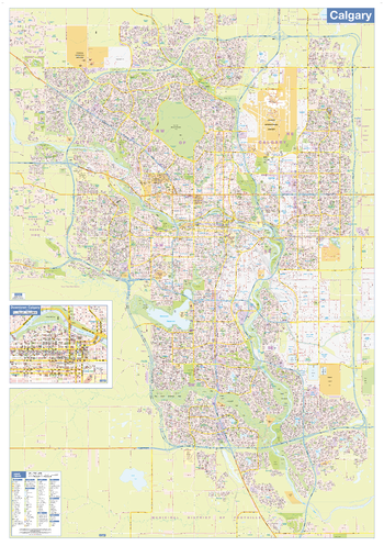
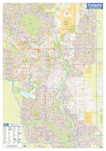
Calgary Wall Map - Street Detail - Large
This large wall map shows highly detailed local information for the city of Calgary. Full street labeling along with transit information, parks, schools, churches and landmarks throughout the city are displayed.
The map has been designed in a very clear and legible manner with a traditional Canadian street map style embraced by map buyers over many years.
Page Size: 37.25 x 53.5 in (942 x 1357 mm)
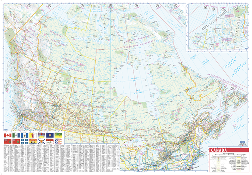
Canada Wall Map with Flags - English and French
This wall map of Canada is a bilingual French-English product, making this an ideal product in Canada for schools, businesses and public areas.
Time zones, provincial flags, and an easy reference place name index make this a highly informative and attractive product.
Page Size: 39.5 x 27.25 in (1003 x 692 mm)
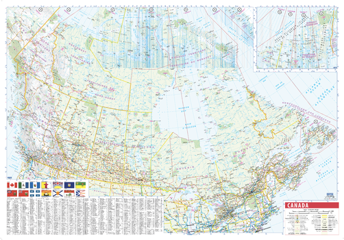
Canada Wall Map with Flags - English and French - Large
This large wall map of Canada is a bilingual French-English product, making this an ideal product in Canada for schools, businesses and public areas.
Time zones, provincial flags, and an easy reference place name index make this a highly informative and attractive product.
Page Size: 54 x 37.5 in (1372 x 953 mm)
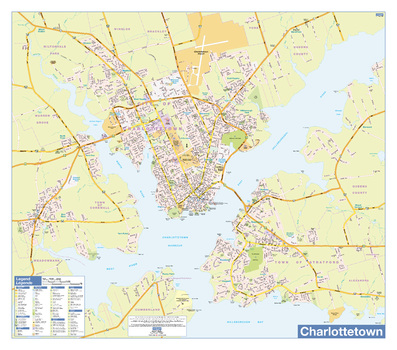
Charlottetown Downtown - Compact
Map of downtown Charlottetown showing all roads, road names, political boundaries, transit, points of interest, parks, schools, churches, public buildings and landmarks.
Page Size: 21.5 x 16.25 in (546 x 413 mm)
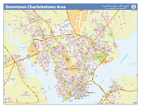
Charlottetown Wall Map - Street Detail
This wall map shows highly detailed local information for the city of Charlottetown. Full street labeling along with transit information, parks, schools, churches and landmarks throughout the city are displayed.
The map has been designed in a very clear and legible manner with a traditional Canadian street map style embraced by map buyers over many years.
Page Size: 33 x 29 in (838 x 737 mm)
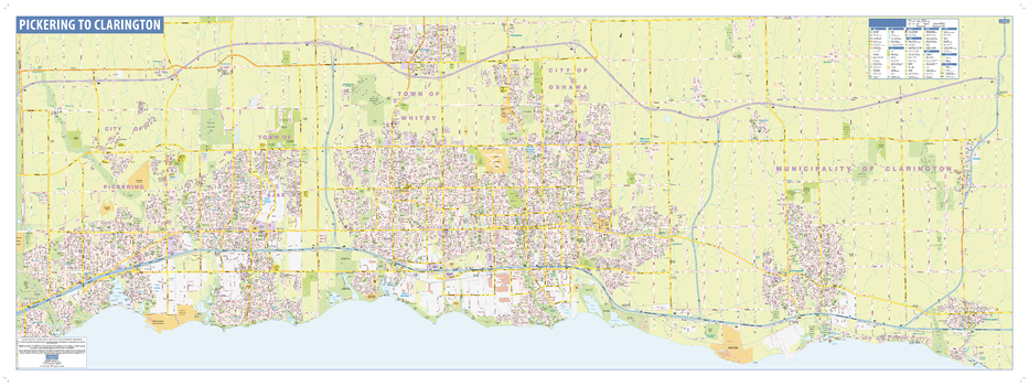
Durham Wall Map - Street Detail
This wall map shows highly detailed local information for the Region of Durham. Full street labeling along with transit information, parks, schools, churches and landmarks throughout the city are displayed.
The map has been designed in a very clear and legible manner with a traditional Canadian street map style embraced by map buyers over many years.
Page Size: 63 x 23 in (1600 x 584 mm)
Eastern Atlantic Provinces
Create custom regional maps in Canada from this series of attractive detailed road maps covering most of the populated areas across Canada. Maps are developed from Lucidmap’s iconic Canadian cartography. Coverage of the eastern Atlantic provinces includes Nova Scotia, Prince Edward Island and eastern New Brunswick. Eastern-most communities in New Brunswick include Jacquet River, Blackville, Kingston and Rocky Corner. Native scale is 1:250,000.
Eastern Ontario Western Québec
Create custom regional maps in Canada from this series of attractive detailed road maps covering most of the populated areas across Canada. Maps are developed from Lucidmap’s iconic Canadian cartography. Coverage of eastern Ontario and western Québec ranges along the Saint Lawrence River from Saint-Marc-des-Carrières, QC to Lake Ontario, and west to Colborne; and along the Ottawa River from Stonecliffe, ON to Montréal, QC. Communities in Québec north of this area include Mont-Laurier, Saint-Michel-des-Saints, La Tuque and Rivière-à-Pierre. The southern limit of the coverage is the Canada-USA border. Native scale is 1:250,000.
Eastern Québec
Create custom regional maps in Canada from this series of attractive detailed road maps covering most of the populated areas across Canada. Maps are developed from Lucidmap’s iconic Canadian cartography. Coverage in eastern Québec is along the Saint Lawrence river from Cap-Chat to Lotbinèire along the southern shore, and Rivière-Portneuf to Deschambault on the northern shore. The southern boundary of the map is the Canada-USA border. The area around the Saguenay River to Lac Saint-Jean is also included. Native scale is 1:250,000.