Collins

Antarctica Atlas Plate
This map of Antarctica is a benchmark of cartographic excellence, taken from the industry leading Comprehensive Atlas of the World series by Collins. There is a high level of detail packed into the map, yet the positioning of every element is carefully chosen to make the map coherent and attractive. The sea level and water depth are shown in simple, intuitive colours that make it easy to understand the data being presented. The inset map shows the Antarctic Circle overlayed with the movement of the sea ice edge from 1981 to 2018. Additional detailing reveals locations of identified ice shelves and mountain ranges, including the Transantarctic Mountains.
Page Size: 22.25 x 16.25 in (565 x 413 mm)

Antarctica Atlas Plate – Enlarged
This map of Antarctica is a benchmark of cartographic excellence, taken from the industry leading Comprehensive Atlas of the World series by Collins. There is a high level of detail packed into the map, yet the positioning of every element is carefully chosen to make the map coherent and attractive. The sea level and water depth are shown in simple, intuitive colours that make it easy to understand the data being presented. The inset map shows the Antarctic Circle overlayed with the movement of the sea ice edge from 1981 to 2018. Additional detailing reveals locations of identified ice shelves and mountain ranges, including the Transantarctic Mountains.
Page Size: 33 x 24 in (834 x 609 mm)

Arctic Ocean Atlas Plate
This map of The Arctic Ocean is a benchmark of cartographic excellence, taken from the industry leading Comprehensive Atlas of the World series by Collins. There is a high level of detail packed into the map, yet the positioning of every element is carefully chosen to make the map coherent and attractive. The sea level and water depth are shown in simple, intuitive colours that make it easy to understand the data being presented. The inset map shows the Arctic Circle overlayed with the movement of the sea ice edge from 1981 to 2018. This map also provides detailed images of the Elizabeth Islands of Northern Canada, Alaska, Northern Russia, Greenland and Iceland.
Page Size: 22.25 x 16.25 in (565 x 413 mm)

Arctic Ocean Atlas Plate – Enlarged
This map of The Arctic Ocean is a benchmark of cartographic excellence, taken from the industry leading Comprehensive Atlas of the World series by Collins. There is a high level of detail packed into the map, yet the positioning of every element is carefully chosen to make the map coherent and attractive. The sea level and water depth are shown in simple, intuitive colours that make it easy to understand the data being presented. The inset map shows the Arctic Circle overlayed with the movement of the sea ice edge from 1981 to 2018. This map also provides detailed images of the Elizabeth Islands of Northern Canada, Alaska, Northern Russia, Greenland and Iceland.
Page Size: 33 x 24 in (834 x 609 mm)

Australia Atlas Plate
This map of Australia is a benchmark of cartographic excellence, taken from the industry leading Comprehensive Atlas of the World series by Collins. There is a high level of detail packed into the map, with five additional inset maps showing the surrounding islands: Cocos (Keeling) Islands, Christmas Island, Macquarie Island, Norfolk Island, and Lord Howe Island. The state and territory capitals of Brisbane, Darwin, Hobart (Tasmania), Melbourne, Perth and Sydney are easily identifiable, as is Australia’s Capital city, Canberra. Further detailing identifies mountain ranges such as the Great Dividing Range, and reef systems, including: the Great Barrier Reef. Each element is carefully chosen to make the map a coherent and attractive visual guide to Australia.
Page Size: 22.25 x 16.25 in (565 x 413 mm)

Australia Atlas Plate – Enlarged
This map of Australia is a benchmark of cartographic excellence, taken from the industry leading Comprehensive Atlas of the World series by Collins. There is a high level of detail packed into the map, with five additional inset maps showing the surrounding islands: Cocos (Keeling) Islands, Christmas Island, Macquarie Island, Norfolk Island, and Lord Howe Island. The state and territory capitals of Brisbane, Darwin, Hobart (Tasmania), Melbourne, Perth and Sydney are easily identifiable, as is Australia’s Capital city, Canberra. Further detailing identifies mountain ranges such as the Great Dividing Range, and reef systems, including: the Great Barrier Reef. Each element is carefully chosen to make the map a coherent and attractive visual guide to Australia.
Page Size: 33 x 24 in (834 x 609 mm)

Austria Atlas Plate
This map of Austria is a benchmark of cartographic excellence, taken from the industry leading Comprehensive Atlas of the World series by Collins. There is a high level of detail packed into the map, yet the positioning of every element is carefully chosen to make the map coherent and attractive. Austria’s states are clearly labelled with their capitals of Salzburg, Innsbruck, Graz and Linz – as well as the Capital city: Wien (Vienna) – specifically marked. The map also provides additional detailing of Southeast Germany, Northern Italy, and Northern Slovenia. Each element is carefully chosen to make the map a coherent and attractive visual guide to Austria.
Page Size: 22.25 x 16.25 in (565 x 413 mm)

Austria Atlas Plate – Enlarged
This map of Austria is a benchmark of cartographic excellence, taken from the industry leading Comprehensive Atlas of the World series by Collins. There is a high level of detail packed into the map, yet the positioning of every element is carefully chosen to make the map coherent and attractive. Austria’s states are clearly labelled with their capitals of Salzburg, Innsbruck, Graz and Linz – as well as the Capital city: Wien (Vienna) – specifically marked. The map also provides additional detailing of Southeast Germany, Northern Italy, and Northern Slovenia. Each element is carefully chosen to make the map a coherent and attractive visual guide to Austria.
Page Size: 33 x 24 in (834 x 609 mm)
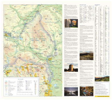
Brecon Beacons National Park Map - East
With clear mapping and a high level of detail, explore Brecon Beacons National Park easily with maps from Collins. This map identifies key park, tourist, and travel information, presented alongside a selection of photographs, making it an ideal companion for those exploring this beautiful area of Wales.
Page Size: 25 x 22.25 in (630 x 560 mm)
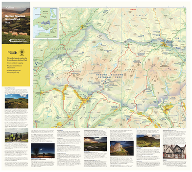
Brecon Beacons National Park Map - West
With clear mapping and a high level of detail, explore Brecon Beacons National Park easily with maps from Collins. This map identifies key park, tourist, and travel information, presented alongside a selection of photographs, making it an ideal companion for those exploring this beautiful area of Wales.
Page Size: 25 x 22.25 in (630 x 560 mm)
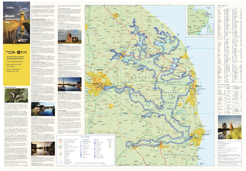
Broads National Park Map
With clear mapping and a high level of detail, explore the Broads National Park easily with maps from Collins. This map identifies key park, tourist, and travel information, presented alongside a selection of photographs, making it an ideal companion for those exploring this beautiful area of Eastern England.
Page Size: 32 x 22.25 in (810 x 560 mm)
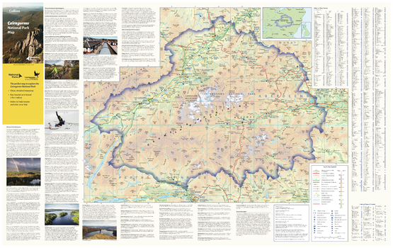
Cairngorms National Park Map
With clear mapping and a high level of detail, explore Cairngorms National Park easily with maps from Collins. This map identifies key park, tourist, and travel information, presented alongside a selection of photographs, making it an ideal companion for those exploring this beautiful area of the Scottish Highlands.
Page Size: 35.5 x 22.25 in (900 x 560 mm)

Canada and Greenland Atlas Plate
This map of Canada and Greenland is a benchmark of cartographic excellence, taken from the industry leading Comprehensive Atlas of the World series by Collins. Major cities such as Ottawa and Vancouver are easily identifiable, as are the Capitals of Toronto and Nuuk. International borders are clearly marked as are provincial and territorial boundaries within Canada. Geographical features, such as the Rocky Mountain range are also shown. Supplementary mapping also shows Iceland in full and the north of the United States. An additional inset map provides a road map of Toronto. Each element is carefully chosen to make the map a coherent and attractive visual guide to Canada and Greenland.
Page Size: 21.75 x 16 in (551 x 402 mm)

Canada and Greenland Atlas Plate – Enlarged
This map of Canada and Greenland is a benchmark of cartographic excellence, taken from the industry leading Comprehensive Atlas of the World series by Collins. Major cities such as Ottawa and Vancouver are easily identifiable, as are the Capitals of Toronto and Nuuk. International borders are clearly marked as are provincial and territorial boundaries within Canada. Geographical features, such as the Rocky Mountain range are also shown. Supplementary mapping also shows Iceland in full and the north of the United States. An additional inset map provides a road map of Toronto. Each element is carefully chosen to make the map a coherent and attractive visual guide to Canada and Greenland.
Page Size: 33 x 24 in (834 x 609 mm)
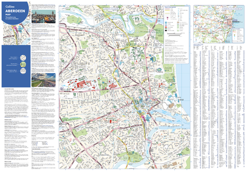
Collins Aberdeen Map
With clear mapping and a high level of detail, explore Aberdeen easily with maps from Collins. An ideal guide for tourists and residents alike, this map identifies many tourist attractions, places to stay, and cafes and restaurants, including the Aberdeen Maritime Museum and Duthie Park Winter Gardens. Extending from the central area to the airport and along the coast, this is an essential map for any visitors exploring Aberdeen.
Page Size: 32 x 22.25 in (810 x 560 mm)
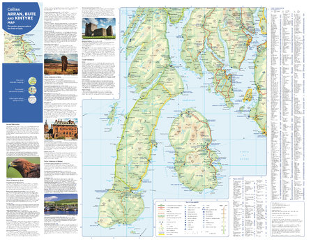
Collins Arran, Bute and Kintyre Map
With clear mapping and a high level of detail, explore Arran, Bute and Kintyre easily with maps from Collins. This map identifies tourist attractions and places to stay, as well as restaurants and tourist information sites, making it an essential map for any visitors or residents exploring the Firth of Clyde.
Page Size: 28.5 x 22.25 in (720 x 560 mm)
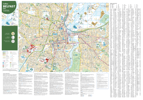
Collins Belfast Map
With clear mapping and a high level of detail, explore Belfast easily with maps from Collins. This map identifies tourist attractions, places to stay, and transport links, as well as restaurants and tourist information sites, making it an essential map for any visitors or residents exploring Northern Ireland’s Capital city.
Page Size: 32 x 22.25 in (810 x 560 mm)
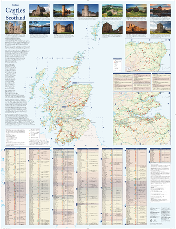
Collins Castles Map of Scotland
Pictorial map featuring over 700 castles and fortified houses. Includes an easy-to-use index listing visitor information and an attractive selection of photographs.
- Over 700 castles and fortifications
- Index comprises map references, the age and type of each castle, public access details, Historic Scotland and National Trust for Scotland ownership, notable grounds and gardens, telephone numbers and websites
- Highlights Scotland’s finest castles, castellated mansions and also the best castles for children
- Attractive photographs of a selection of castles, together with a brief account of their history
- A brief history of Scottish castles and information on architectural types and periods of construction
- Internet links and suggested reading for further information
Page Size: 30.75 x 40 in (775 x 1015 mm)
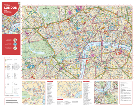
Collins Central London Map
With clear mapping and a high level of detail, explore central London easily with maps from Collins. From Regent’s Park in the north to Kennington in the south, Kensington Garden’s in the west to Tower Bridge in the east. Including theatres, shops, underground stations and congestion zone boundaries, this inclusive map is the perfect guide to central London for tourists and residents alike.
Page Size: 28.5 x 22.25 in (720 x 560 mm)
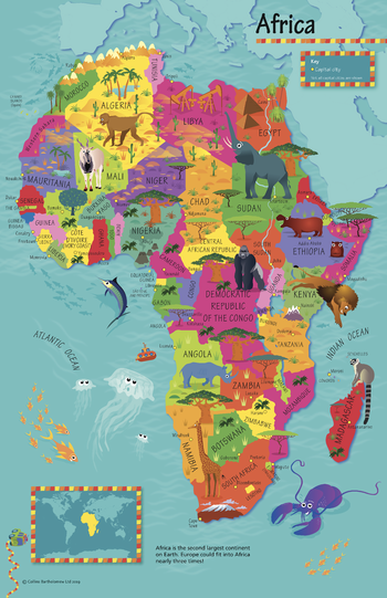
Collins Children's Africa Wall Map
This highly illustrated pictorial map is designed to take children on a journey of discovery around the countries of Africa. The mapping is clear, colourful and highly informative and shows countries and capital cities. Stunning illustrations are used to depict themes such as national emblems, customs, food, birds, animals, buildings and sports to help younger readers gain an understanding of peoples around the world. The perfect introduction to maps for 4-8 year olds. Illustrated by Steve Evans.
Page Size: 19.5 x 30 in (492 x 760 mm)