Benchmark Maps
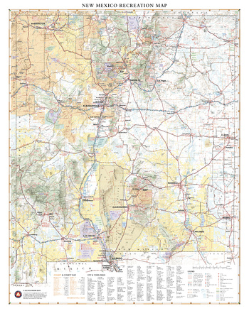
New Mexico Recreation Wall Map – 26 inch
New Mexico’s unique desert-to-mountain landscapes and rich cultural heritage earn its nickname the Land of Enchantment. This wall map illustrates the terrain features, public lands, and roadways that connect the desert southwest with the southern reaches of the Rocky Mountains.
Page Size: 26 x 32.5 in (660 x 826 mm)
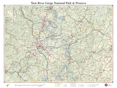
New River Gorge National Park
Contrary to its name, the New River is one of North America’s oldest rivers and has been cutting and carving the gorge to which it lends its title for millions of years. Up to 1,000 feet deep in places, the gorge is a hot spot for rock climbing and whitewater rafting in West Virginia. New River Gorge National River protects 53 river miles of this forested canyon along with remnants of the region’s mining and timber history. This wall map illustrates the area’s diverse terrain, public land ownership, and recreation sites.
Page Size: 26 x 34.75 in (660 x 881 mm)
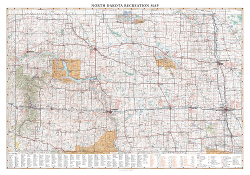
North Dakota Recreation Wall Map – 26 inch
North Dakota is traversed by east to west by I-94 from Fargo to Theodore Roosevelt National Park and the Little Missouri National Grassland. This wall map highlights road and recreation details including park & monuments, boating & fishing access, campgrounds, historic sites, and more.
Page Size: 37.25 x 26 in (943 x 660 mm)
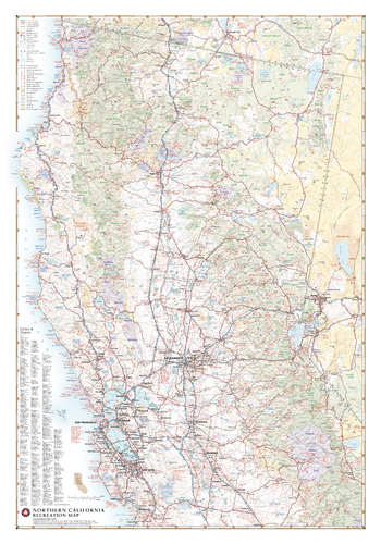
Northern California Recreation Wall Map – 26 inch
Northern California has an identity all its own, containing such iconic natural features as Redwood forests, Yosemite Valley, Lake Tahoe, San Francisco Bay and Mt. Shasta. From the Sierra Nevada Mountains to the Pacific Coast, this wall map illustrates the northern half of The Golden State, highlighting its public lands and roadways that make them accessible to travelers of all interests.
Page Size: 26 x 37.25 in (660 x 943 mm)
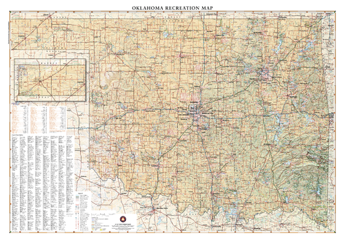
Oklahoma Recreation Wall Map – 26 inch
Oklahoma lies where the sweeping prairies of the Great Plains meet the western shoulder of the Ozark Mountains. This wall map illustrates The Sooner State’s array of country roads and recreation opportunities.
Page Size: 37.25 x 26 in (943 x 660 mm)
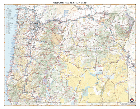
Oregon Recreation Wall Map – 26 inch
With its rugged but peaceful Pacific Coast and inland features like Crater Lake and myriad mountain peaks and hidden waterfalls, Oregon is a favorite destination for travelers across the American West. This wall map illustrates the public lands and recreation hotspots across The Beaver State.
Page Size: 33.5 x 26 in (849 x 660 mm)
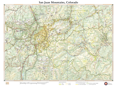
San Juan Mountains Colorado
This wall map illustrates the rugged San Juan mountain range in southwestern Colorado. Far removed from Colorado’s bustling Front Range cities, the San Juans host many unique mountain towns including Ouray, Telluride, Silverton, Creede, and Lake City. Map features include public land boundaries, recreation points of interest, and the network of highways and back roads that provide access to this secluded region.
Page Size: 26 x 34.75 in (660 x 881 mm)
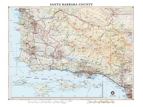
Santa Barbara County California
Santa Barbara County is an area of diverse geology and ecology, marking the transition between northern and southern California. Much but not all of the natural coastal area and habitats have been protected from development, save a few ranches. And nearly 25,000 additional acres of pristine California coastline will now be protected indefinitely, thanks to a recent $165 million donation to The Nature Conservancy by Jack & Laura Dangermond, co-founders of Esri. This area, adjacent to the Los Padres National Forest, will now serve as a nature preserve and scientific laboratory for the University of California – Santa Barbara.
Page Size: 24 x 32 in (610 x 813 mm)
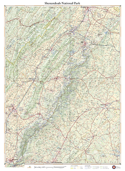
Shenandoah National Park
Skyline Drive and the Appalachian Trail trace the spine of the Blue Ridge Mountains through this landscape of craggy peaks, deep forests, and rolling ridges. More than a third of the park has been designated as wilderness, providing a welcome escape from nearby cities. This wall map details the terrain and recreation features inside Shenandoah National Park and highlights its surrounding communities.
Page Size: 38.25 x 28 in (972 x 711 mm)
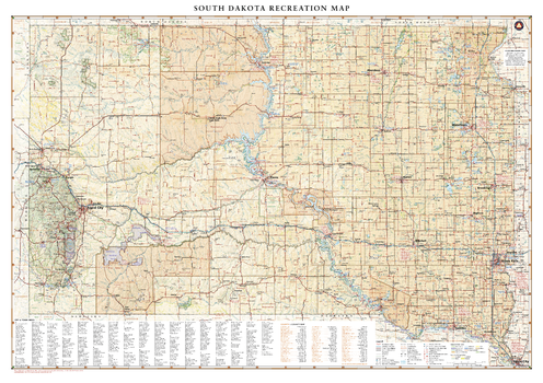
South Dakota Recreation Wall Map – 26 inch
South Dakota is home to the famous Black Hills National Forest and Mount Rushmore National Monument, iconic attractions for road travelers around the world. This map illustrates the public lands and recreation potential of South Dakota, from Deadwood and Sturgis to its eastern capital in Sioux Falls.
Page Size: 37 x 26 in (936 x 660 mm)
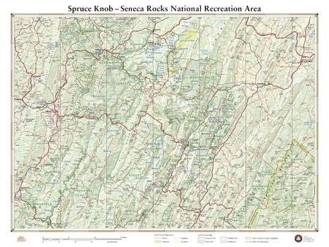
Spruce Knob Seneca Rocks National Recreation Area
This wall map illustrates some of West Virginia’s best public lands and recreation sites. Spruce Knob is the state’s highest point at 4,863 ft., and Seneca Rocks features some of the best rock climbing in the eastern U.S. This map also highlights recreation access in the surrounding Monongahela National Forest, several wildlife management areas, and nearby state parks.
Page Size: 26 x 34.75 in (660 x 881 mm)
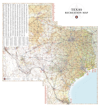
Texas Recreation Wall Map – 26 inch
Texas has a reputation for big country, big cities, and Big Bend National Park. This wall map illustrates the vast countryside and recreation attractions throughout The Lone Star State, from Gulf Coast and fields of Blue Bonnets in the east to the panhandle’s Palo Duro Canyon and the Guadalupe Mountains in the west.
Page Size: 26 x 28 in (660 x 708 mm)
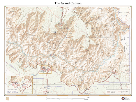
The Grand Canyon
This wall map details the heart of The Grand Canyon in northern Arizona. Map highlights include the canyon’s myriad geologic features, drainage detail for the many springs and tributaries that feed into the Colorado River, and man-made features such as trails, campgrounds, and river crossings.
Page Size: 26 x 34.75 in (660 x 881 mm)
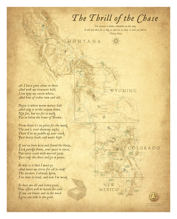
The Thrill of the Chase
This wall map illustrates the searchable area for Forrest Fenn’s famous treasure chest. Our map first appeared as a fold-out in Forrest’s 2013 memoir Too Far To Walk. His treasure was found in the spring of 2020 at an undisclosed location in Wyoming. Within a few months Forrest passed away at his home in Santa Fe, New Mexico. We keep this map available as a keepsake for those who experienced the Thrill of the Chase.
Page Size: 26 x 32 in (660 x 813 mm)

Utah Recreation Wall Map – 26 inch
Utah boasts what is perhaps the best concentration of national parks in the world, known as The Mighty Five: Zion, Bryce Canyon, Capitol Reef, Canyonlands, and Arches. These diverse and iconic desert landscapes, along with the Great Salt Lake and world-class alpine skiing in the north, draw travelers to The Beehive State year-round.
Page Size: 26 x 32.5 in (660 x 826 mm)
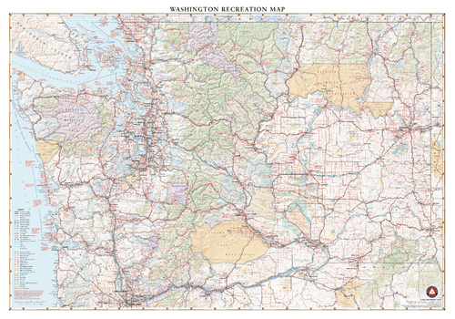
Washington Recreation Wall Map – 26 inch
Washington features all the best natural landscapes of the Pacific Northwest, including skyscraping volcanic peaks, immense temperate forests, coastal wonders, inlet waterways, and manicured wine country. This wall map illustrates the public lands, scenic roadways, and recreation possibilities throughout The Evergreen State.
Page Size: 37.25 x 26 in (943 x 660 mm)
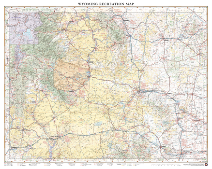
Wyoming Recreation Wall Map – 26 inch
Wyoming is home to both Grand Teton and Yellowstone National Parks in its northwest corner, but there are more mountain ranges and rivers that extend beyond these iconic parks. This wall map illustrates The Cowboy State’s complete public land coverage and the scenic roadways that connect the Wind River Range to the Laramie Range, the Medicine Bow Mountains to the Bighorn Mountains, and the historic sites and recreation opportunities throughout.
Page Size: 32.5 x 26 in (826 x 660 mm)