Backroad Mapbooks
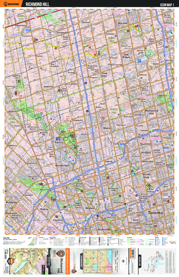
CCON01 Richmond Hill – Cottage Country Ontario Topo
This recreation topographic map for Richmond Hill highlights all the logging/resource roads, hunting areas, fishing lakes & streams, campsites, paddling routes for canoeing and kayaking, wildlife viewing areas, multi-use trails for hiking, biking, horseback riding, cross-country skiing and snowshoeing, motorized trails for ATVing and snowmobiling & more. Covering 1,090 km2 (420 mi2), this 1:50,000 scale map measures 29 x 38 km (18 x 24 mi), providing you with more topographic and recreational detail for the Richmond Hill area than any other map on the market. New features include enhanced Crown land, countless new roads and trails and a wealth of recreational Points of Interest. Included on this map are Aurora, Bolton, Brampton, Etobicoke, King City, Malton, Mount Chinguacousy, Rexdale, Thornhill, North York, Oak Ridges, Richmond Hill, Toronto, Uplands Ski Centre and more!
Page Size: 24 x 37 in (610 x 940 mm)
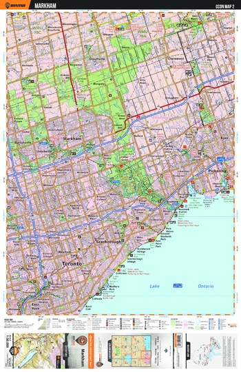
CCON02 Markham - Cottage Country Ontario Topo
This recreation topographic map for Markham highlights all the logging/resource roads, hunting areas, fishing lakes & streams, campsites, paddling routes for canoeing and kayaking, wildlife viewing areas, multi-use trails for hiking, biking, horseback riding, cross-country skiing and snowshoeing, motorized trails for ATVing and snowmobiling & more. Covering 1,090 km2 (420 mi2), this 1:50,000 scale map measures 29 x 38 km (18 x 24 mi), providing you with more topographic and recreational detail for the Richmond Hill area than any other map on the market. New features include enhanced Crown land, countless new roads and trails and a wealth of recreational Points of Interest. Included on this map are Toronto, Markham, Scarborough, Claremont, East York, Pickering and more!
Page Size: 24 x 37 in (610 x 940 mm)
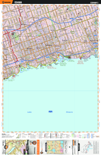
CCON03 Oshawa - Cottage Country Ontario Topo
This recreation topographic map for Oshawa highlights all the logging/resource roads, hunting areas, fishing lakes & streams, campsites, paddling routes for canoeing and kayaking, wildlife viewing areas, multi-use trails for hiking, biking, horseback riding, cross-country skiing and snowshoeing, motorized trails for ATVing and snowmobiling & more. Covering 1,090 km2 (420 mi2), this 1:50,000 scale map measures 29 x 38 km (18 x 24 mi), providing you with more topographic and recreational detail for the Richmond Hill area than any other map on the market. New features include enhanced Crown land, countless new roads and trails and a wealth of recreational Points of Interest. Included on this map are Oshawa, Hampton, Brooklin, Darlington, Provincial, Ajax, Lakeview Park and more!
Page Size: 24 x 37 in (610 x 940 mm)
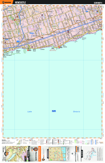
CCON04 Newcastle - Cottage Country Ontario Topo
This recreation topographic map for Newcastle highlights all the logging/resource roads, hunting areas, fishing lakes & streams, campsites, paddling routes for canoeing and kayaking, wildlife viewing areas, multi-use trails for hiking, biking, horseback riding, cross-country skiing and snowshoeing, motorized trails for ATVing and snowmobiling & more. Covering 1,090 km2 (420 mi2), this 1:50,000 scale map measures 29 x 38 km (18 x 24 mi), providing you with more topographic and recreational detail for the Richmond Hill area than any other map on the market. New features include enhanced Crown land, countless new roads and trails and a wealth of recreational Points of Interest. Included on this map are Port Hope, Starkville, Orono, New Castle, Wesleyville, Newtonville, Port Britain, Bowmanville and more!
Page Size: 24 x 37 in (610 x 940 mm)
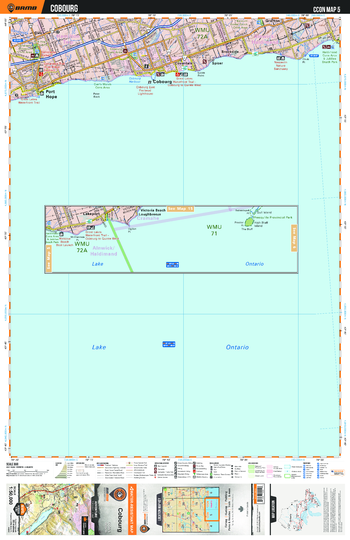
CCON05 Cobourg - Cottage Country Ontario Topo
This recreation topographic map for Cobourg highlights all the logging/resource roads, hunting areas, fishing lakes & streams, campsites, paddling routes for canoeing and kayaking, wildlife viewing areas, multi-use trails for hiking, biking, horseback riding, cross-country skiing and snowshoeing, motorized trails for ATVing and snowmobiling & more. Covering 1,090 km2 (420 mi2), this 1:50,000 scale map measures 29 x 38 km (18 x 24 mi), providing you with more topographic and recreational detail for the Richmond Hill area than any other map on the market. New features include enhanced Crown land, countless new roads and trails and a wealth of recreational Points of Interest. Included on this map are Cobourg, Port Hope, Grafton, Dale, Coverdale, Lake Ontario, Brookside and more!
Page Size: 24 x 37 in (610 x 940 mm)
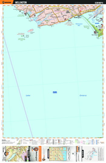
CCON06 Wellington - Cottage Country Ontario Topo
This recreation topographic map for Wellington highlights all the logging/resource roads, hunting areas, fishing lakes & streams, campsites, paddling routes for canoeing and kayaking, wildlife viewing areas, multi-use trails for hiking, biking, horseback riding, cross-country skiing and snowshoeing, motorized trails for ATVing and snowmobiling & more. Covering 1,090 km2 (420 mi2), this 1:50,000 scale map measures 29 x 38 km (18 x 24 mi), providing you with more topographic and recreational detail for the Richmond Hill area than any other map on the market. New features include enhanced Crown land, countless new roads and trails and a wealth of recreational Points of Interest. Included on this map are Wellington, Sandbanks Provincial Park, Prince Edward, Hallowell, North Beach, Provincial, Hillier, Millenium Trail and more!
Page Size: 24 x 37 in (610 x 940 mm)
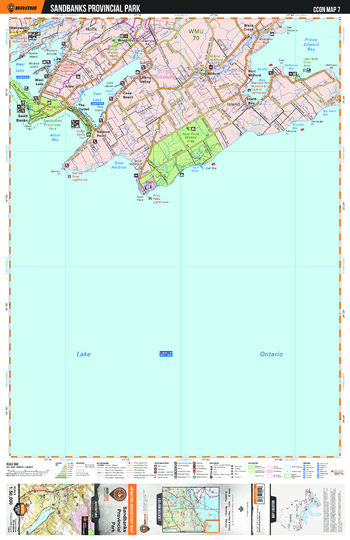
CCON07 Sandbanks Provincial Park - Cottage Country Ontario Topo
This recreation topographic map for Sandbanks Provinical Park highlights all the logging/resource roads, hunting areas, fishing lakes & streams, campsites, paddling routes for canoeing and kayaking, wildlife viewing areas, multi-use trails for hiking, biking, horseback riding, cross-country skiing and snowshoeing, motorized trails for ATVing and snowmobiling & more. Covering 1,090 km2 (420 mi2), this 1:50,000 scale map measures 29 x 38 km (18 x 24 mi), providing you with more topographic and recreational detail for the Richmond Hill area than any other map on the market. New features include enhanced Crown land, countless new roads and trails and a wealth of recreational Points of Interest. Included on this map are Sandbanks Provincial Park, Millenium Waterfront Trail, Prince Edward, Lake Ontario, Black Creek, Sand Banks, Salmon Point and more!
Page Size: 24 x 37 in (610 x 940 mm)
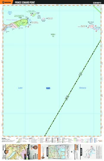
CCON08 Prince Edward Point - Cottage Country Ontario Topo
This recreation topographic map for Prince Edward Point highlights all the logging/resource roads, hunting areas, fishing lakes & streams, campsites, paddling routes for canoeing and kayaking, wildlife viewing areas, multi-use trails for hiking, biking, horseback riding, cross-country skiing and snowshoeing, motorized trails for ATVing and snowmobiling & more. Covering 1,090 km2 (420 mi2), this 1:50,000 scale map measures 29 x 38 km (18 x 24 mi), providing you with more topographic and recreational detail for the Richmond Hill area than any other map on the market. New features include enhanced Crown land, countless new roads and trails and a wealth of recreational Points of Interest. Included on this map are Prince Edward, Bay, Point, Lake Ontario, Long Point, Timber Island, Provincial, Main Duck Island, False Ducks Islands and more!
Page Size: 24 x 37 in (610 x 940 mm)
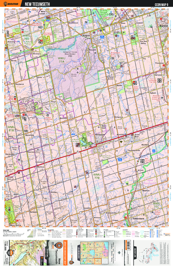
CCON09 New Tecumseth - Cottage Country Ontario Topo
This recreation topographic map for New Tecumseth highlights all the logging/resource roads, hunting areas, fishing lakes & streams, campsites, paddling routes for canoeing and kayaking, wildlife viewing areas, multi-use trails for hiking, biking, horseback riding, cross-country skiing and snowshoeing, motorized trails for ATVing and snowmobiling & more. Covering 1,090 km2 (420 mi2), this 1:50,000 scale map measures 29 x 38 km (18 x 24 mi), providing you with more topographic and recreational detail for the Richmond Hill area than any other map on the market. New features include enhanced Crown land, countless new roads and trails and a wealth of recreational Points of Interest. Included on this map are New Tecumseth, Alliston, Tottenham, Ganaraska Trail, Sheldon, Borden, Baxter, Beeton and more!
Page Size: 24 x 37 in (610 x 940 mm)
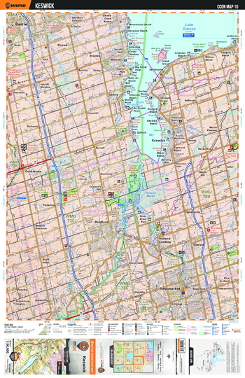
CCON10 Keswick - Cottage Country Ontario Topo
This recreation topographic map for Keswick highlights all the logging/resource roads, hunting areas, fishing lakes & streams, campsites, paddling routes for canoeing and kayaking, wildlife viewing areas, multi-use trails for hiking, biking, horseback riding, cross-country skiing and snowshoeing, motorized trails for ATVing and snowmobiling & more. Covering 1,090 km2 (420 mi2), this 1:50,000 scale map measures 29 x 38 km (18 x 24 mi), providing you with more topographic and recreational detail for the Richmond Hill area than any other map on the market. New features include enhanced Crown land, countless new roads and trails and a wealth of recreational Points of Interest. Included on this map are Keswick, Lake Simcoe, New Market, Beach, Bradford, Cookstown, Bethesda, Cook's Bay and more!
Page Size: 24 x 37 in (610 x 940 mm)
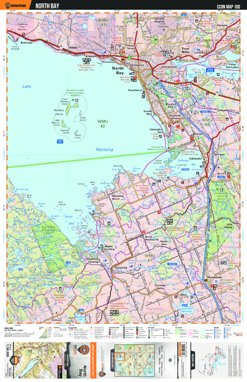
CCON100 North Bay - Cottage Country Ontario Topo
This recreation topographic map for North Bay highlights all the logging/resource roads, hunting areas, fishing lakes & streams, campsites, paddling routes for canoeing and kayaking, wildlife viewing areas, multi-use trails for hiking, biking, horseback riding, cross-country skiing and snowshoeing, motorized trails for ATVing and snowmobiling & more. Covering 1,090 km2 (420 mi2), this 1:50,000 scale map measures 29 x 38 km (18 x 24 mi), providing you with more topographic and recreational detail for the Richmond Hill area than any other map on the market. New features include enhanced Crown land, countless new roads and trails and a wealth of recreational Points of Interest. Included on this map are North Bay, Nipissing, Powassen, Lake Nipissing, South Bay Provincial Park, Trans Canada Trail and more!
Page Size: 24 x 37 in (610 x 940 mm)
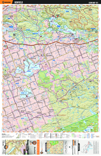
CCON101 Bonfield - Cottage Country Ontario Topo
This recreation topographic map for Bonfield highlights all the logging/resource roads, hunting areas, fishing lakes & streams, campsites, paddling routes for canoeing and kayaking, wildlife viewing areas, multi-use trails for hiking, biking, horseback riding, cross-country skiing and snowshoeing, motorized trails for ATVing and snowmobiling & more. Covering 1,090 km2 (420 mi2), this 1:50,000 scale map measures 29 x 38 km (18 x 24 mi), providing you with more topographic and recreational detail for the Richmond Hill area than any other map on the market. New features include enhanced Crown land, countless new roads and trails and a wealth of recreational Points of Interest. Included on this map are Bonfield, Ruthergien, Mattawa River, Algonquin, Provincial, Alderdale, Grand Desert and more!
Page Size: 24 x 37 in (610 x 940 mm)
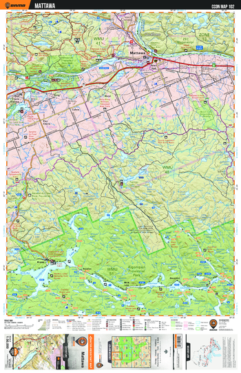
CCON102 Mattawa - Cottage Country Ontario Topo
This recreation topographic map for Mattawa highlights all the logging/resource roads, hunting areas, fishing lakes & streams, campsites, paddling routes for canoeing and kayaking, wildlife viewing areas, multi-use trails for hiking, biking, horseback riding, cross-country skiing and snowshoeing, motorized trails for ATVing and snowmobiling & more. Covering 1,090 km2 (420 mi2), this 1:50,000 scale map measures 29 x 38 km (18 x 24 mi), providing you with more topographic and recreational detail for the Richmond Hill area than any other map on the market. New features include enhanced Crown land, countless new roads and trails and a wealth of recreational Points of Interest. Included on this map are Mattawa, Algonquin, Samuel de Champlain, Provincial, Amable du Fond River, Calvin, Olrig and more!
Page Size: 24 x 37 in (610 x 940 mm)
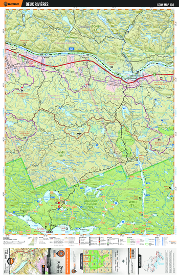
CCON103 Deux Rivières - Cottage Country Ontario Topo
This recreation topographic map for Deux Rivières highlights all the logging/resource roads, hunting areas, fishing lakes & streams, campsites, paddling routes for canoeing and kayaking, wildlife viewing areas, multi-use trails for hiking, biking, horseback riding, cross-country skiing and snowshoeing, motorized trails for ATVing and snowmobiling & more. Covering 1,090 km2 (420 mi2), this 1:50,000 scale map measures 29 x 38 km (18 x 24 mi), providing you with more topographic and recreational detail for the Richmond Hill area than any other map on the market. New features include enhanced Crown land, countless new roads and trails and a wealth of recreational Points of Interest. Included on this map are Deux Rivières, Algonquin Provincial Park, Government Park, Brent, Aylen, Klock and more!
Page Size: 24 x 37 in (610 x 940 mm)
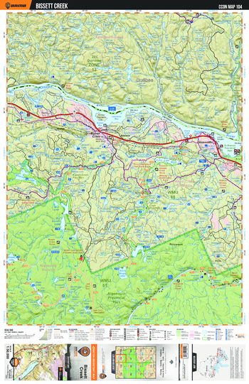
CCON104 Bissett Creek - Cottage Country Ontario Topo
This recreation topographic map for Bissett Creek highlights all the logging/resource roads, hunting areas, fishing lakes & streams, campsites, paddling routes for canoeing and kayaking, wildlife viewing areas, multi-use trails for hiking, biking, horseback riding, cross-country skiing and snowshoeing, motorized trails for ATVing and snowmobiling & more. Covering 1,090 km2 (420 mi2), this 1:50,000 scale map measures 29 x 38 km (18 x 24 mi), providing you with more topographic and recreational detail for the Richmond Hill area than any other map on the market. New features include enhanced Crown land, countless new roads and trails and a wealth of recreational Points of Interest. Included on this map are Bissett Creek, Algonquin, Bissett Creek, Provincial, Gratan, Stonecliffe and more!
Page Size: 24 x 37 in (610 x 940 mm)
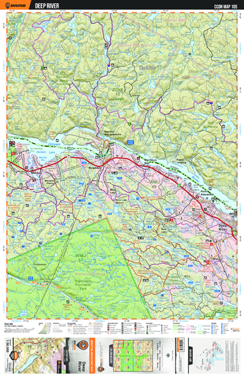
CCON105 Deep River - Cottage Country Ontario Topo
This recreation topographic map for Deep River highlights all the logging/resource roads, hunting areas, fishing lakes & streams, campsites, paddling routes for canoeing and kayaking, wildlife viewing areas, multi-use trails for hiking, biking, horseback riding, cross-country skiing and snowshoeing, motorized trails for ATVing and snowmobiling & more. Covering 1,090 km2 (420 mi2), this 1:50,000 scale map measures 29 x 38 km (18 x 24 mi), providing you with more topographic and recreational detail for the Richmond Hill area than any other map on the market. New features include enhanced Crown land, countless new roads and trails and a wealth of recreational Points of Interest. Included on this map are Deep River, Algonquin Provincial Park, Moor Lake, Rolphton, Bass Lake, Meilleurs Bay and more!
Page Size: 24 x 37 in (610 x 940 mm)
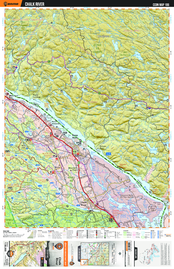
CCON106 Chalk River - Cottage Country Ontario Topo
This recreation topographic map for Chalk River highlights all the logging/resource roads, hunting areas, fishing lakes & streams, campsites, paddling routes for canoeing and kayaking, wildlife viewing areas, multi-use trails for hiking, biking, horseback riding, cross-country skiing and snowshoeing, motorized trails for ATVing and snowmobiling & more. Covering 1,090 km2 (420 mi2), this 1:50,000 scale map measures 29 x 38 km (18 x 24 mi), providing you with more topographic and recreational detail for the Richmond Hill area than any other map on the market. New features include enhanced Crown land, countless new roads and trails and a wealth of recreational Points of Interest. Included on this map are Deep River, Chalk River, Point Alexander, Bass Lake, Meilleurs Bay, Wylie and more!
Page Size: 24 x 37 in (610 x 940 mm)
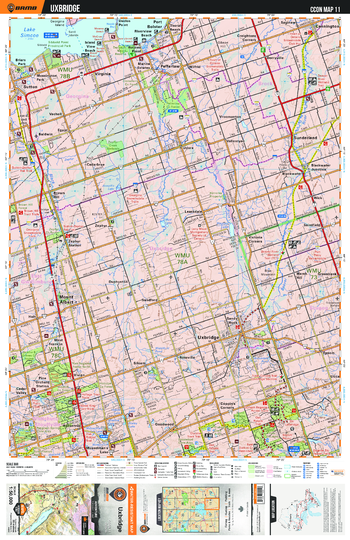
CCON11 Uxbridge - Cottage Country Ontario Topo
This recreation topographic map for Uxbridge highlights all the logging/resource roads, hunting areas, fishing lakes & streams, campsites, paddling routes for canoeing and kayaking, wildlife viewing areas, multi-use trails for hiking, biking, horseback riding, cross-country skiing and snowshoeing, motorized trails for ATVing and snowmobiling & more. Covering 1,090 km2 (420 mi2), this 1:50,000 scale map measures 29 x 38 km (18 x 24 mi), providing you with more topographic and recreational detail for the Richmond Hill area than any other map on the market. New features include enhanced Crown land, countless new roads and trails and a wealth of recreational Points of Interest. Included on this map are Uxbridge, Mount Albert, Sunderland, Sutton, Lake Simcoe, Cedar Valley, Goodwood and more!
Page Size: 24 x 37 in (610 x 940 mm)
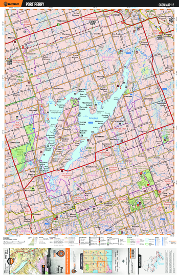
CCON12 Port Perry - Cottage Country Ontario Topo
This recreation topographic map for Port Perry highlights all the logging/resource roads, hunting areas, fishing lakes & streams, campsites, paddling routes for canoeing and kayaking, wildlife viewing areas, multi-use trails for hiking, biking, horseback riding, cross-country skiing and snowshoeing, motorized trails for ATVing and snowmobiling & more. Covering 1,090 km2 (420 mi2), this 1:50,000 scale map measures 29 x 38 km (18 x 24 mi), providing you with more topographic and recreational detail for the Richmond Hill area than any other map on the market. New features include enhanced Crown land, countless new roads and trails and a wealth of recreational Points of Interest. Included on this map are Port Perry, Lindsay, Lake Scugog, Nestleton, Blackstock, Little Britain, Beach and more!
Page Size: 24 x 37 in (610 x 940 mm)
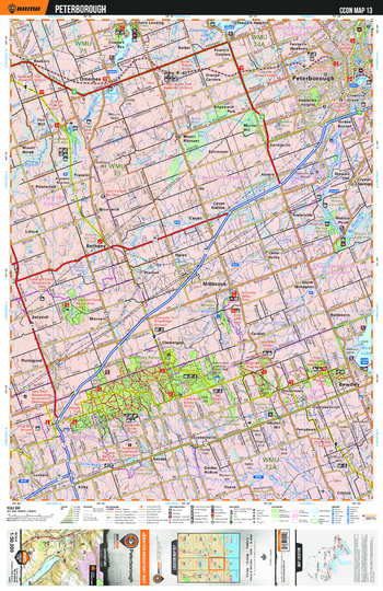
CCON13 Peterborough - Cottage Country Ontario Topo
This recreation topographic map for Peterborough highlights all the logging/resource roads, hunting areas, fishing lakes & streams, campsites, paddling routes for canoeing and kayaking, wildlife viewing areas, multi-use trails for hiking, biking, horseback riding, cross-country skiing and snowshoeing, motorized trails for ATVing and snowmobiling & more. Covering 1,090 km2 (420 mi2), this 1:50,000 scale map measures 29 x 38 km (18 x 24 mi), providing you with more topographic and recreational detail for the Richmond Hill area than any other map on the market. New features include enhanced Crown land, countless new roads and trails and a wealth of recreational Points of Interest. Included on this map are Peterborough, Millbrook, Bethany, Omemee, Ganaraska Trail, Bewdley and more!
Page Size: 24 x 37 in (610 x 940 mm)