Backroad Mapbooks
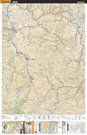
CCBC41 Nazko - Cariboo Chilcotin Coast BC Topo
This recreation topographic map for the Nazko area highlights all the logging roads, trails and recreational Points of Interest including hunting, camping, hiking, mountain biking, canoeing, kayaking, backcountry skiing, wildlife viewing, ATVing, snowmobiling and more. No other map provides you with this level of recreational and topographic detail for the Homathko River area. Covering the Nazko, Nazko Lake Prov Park, Baker Creek, Puntataenkut Lake, Stump Lake, Marmot Lake, Rainbow Lake, Wentworth Lake, Bishop (Brown) Lake, Nazko River and more, this map contains new features such as private land and labelled fish species. The 1:85,000 scale map covers 3,040 km2 (1,175 mi2), measuring 50 x 63.5 km (30 x 39.5 mi).
Page Size: 24 x 37 in (610 x 940 mm)
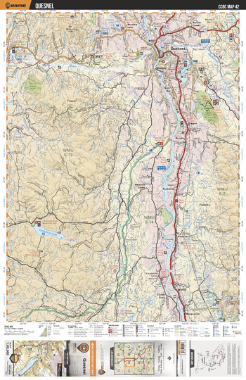
CCBC42 Quesnel - Cariboo Chilcotin Coast BC Topo
This recreation topographic map for the Quesnel area highlights all the logging roads, trails and recreational Points of Interest including hunting, camping, hiking, mountain biking, canoeing, kayaking, backcountry skiing, wildlife viewing, ATVing, snowmobiling and more. No other map provides you with this level of recreational and topographic detail for the Homathko River area. Covering the Quesnel, Tzenzaicut Lake, Quesnel River, Fraser River, Barlow Creek, Dragon Lake, Dragon Mtn, Mount Creek Park, Narcosli Creek, Bouchie Lake and more, this map contains new features such as private land and labelled fish species. The 1:85,000 scale map covers 3,040 km2 (1,175 mi2), measuring 50 x 63.5 km (30 x 39.5 mi).
Page Size: 24 x 37 in (610 x 940 mm)
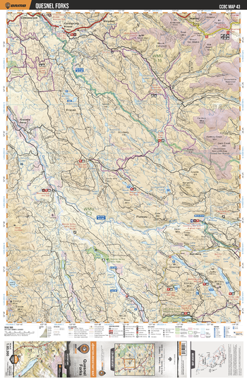
CCBC43 Quesnel Forks - Cariboo Chilcotin Coast BC Topo
This recreation topographic map for the Quesnel Forks area highlights all the logging roads, trails and recreational Points of Interest including hunting, camping, hiking, mountain biking, canoeing, kayaking, backcountry skiing, wildlife viewing, ATVing, snowmobiling and more. No other map provides you with this level of recreational and topographic detail for the Homathko River area. Covering the Quesnel Forks, Coldspring House, Joan Lake, Maud Lake, Nyland Lake, Quesnel River, Deacon Creek Park, Cariboo Mtn, Bootjack Lake, Wingdam and more, this map contains new features such as private land and labelled fish species. The 1:85,000 scale map covers 3,040 km2 (1,175 mi2), measuring 50 x 63.5 km (30 x 39.5 mi).
Page Size: 24 x 37 in (610 x 940 mm)
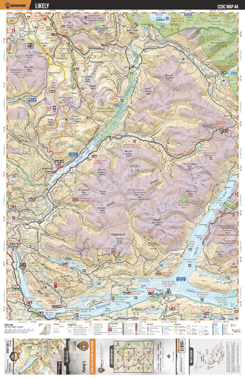
CCBC44 Likely - Cariboo Chilcotin Coast BC Topo
This recreation topographic map for the Likely area highlights all the logging roads, trails and recreational Points of Interest including hunting, camping, hiking, mountain biking, canoeing, kayaking, backcountry skiing, wildlife viewing, ATVing, snowmobiling and more. No other map provides you with this level of recreational and topographic detail for the Homathko River area. Covering the Quesnel Lake, Cariboo River, Likely, Keno Lake, Spanish Lake, Cariboo River Prov Park, Bowron Lake Prov Park, Cariboo Mountains Prov Park, Ghost Lake, Bald Mtn and more, this map contains new features such as private land and labelled fish species. The 1:85,000 scale map covers 3,040 km2 (1,175 mi2), measuring 50 x 63.5 km (30 x 39.5 mi).
Page Size: 24 x 37 in (610 x 940 mm)
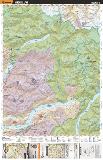
CCBC45 Mitchell Lake - Cariboo Chilcotin Coast BC Topo
This recreation topographic map for the Mitchell Lake area highlights all the logging roads, trails and recreational Points of Interest including hunting, camping, hiking, mountain biking, canoeing, kayaking, backcountry skiing, wildlife viewing, ATVing, snowmobiling and more. No other map provides you with this level of recreational and topographic detail for the Homathko River area. Covering the Quesnel Lake, Hobson Lake, Wells Gray Prov Park, Cariboo Mountains Prov Park, Mitchell Lake, Matthew River, Niagara Creek, Bowron Lake Prov Park, Mitchell River, Warttig Lake and more, this map contains new features such as private land and labelled fish species. The 1:85,000 scale map covers 3,040 km2 (1,175 mi2), measuring 50 x 63.5 km (30 x 39.5 mi).
Page Size: 24 x 37 in (610 x 940 mm)
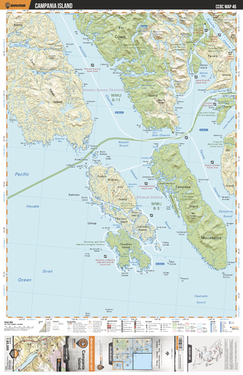
CCBC46 Campania Island - Cariboo Chilcotin Coast BC Topo
This recreation topographic map for the Campania Island area highlights all the logging roads, trails and recreational Points of Interest including hunting, camping, hiking, mountain biking, canoeing, kayaking, backcountry skiing, wildlife viewing, ATVing, snowmobiling and more. No other map provides you with this level of recreational and topographic detail for the Homathko River area. Covering the Lax Ka'gaas/Campania Conservancy, Monckton Nii Luutiksm Conservancy, Ethelda Bay-Tennant Island Conservancy, Union Passage Marine Park, Principe Channel, Estevan Sound, Squally Channel and more, this map contains new features such as private land and labelled fish species. The 1:85,000 scale map covers 3,040 km2 (1,175 mi2), measuring 50 x 63.5 km (30 x 39.5 mi).
Page Size: 24 x 37 in (610 x 940 mm)
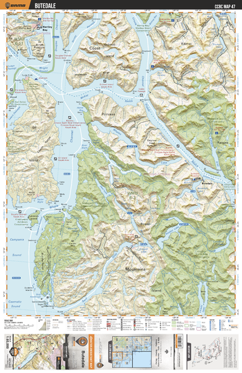
CCBC47 Butedale - Cariboo Chilcotin Coast BC Topo
This recreation topographic map for the Butedale area highlights all the logging roads, trails and recreational Points of Interest including hunting, camping, hiking, mountain biking, canoeing, kayaking, backcountry skiing, wildlife viewing, ATVing, snowmobiling and more. No other map provides you with this level of recreational and topographic detail for the Homathko River area. Covering the Butedale, Hartley Bay, K'lgaan/Klekane Conservancy, Moksgm'ol/Chapple - Cornwall Conservancy, Kitasoo Spirit Bear Conservancy, Royal Island, Whalen Lake, Anchor Lake, Bear Lake, Whale Channel and more, this map contains new features such as private land and labelled fish species. The 1:85,000 scale map covers 3,040 km2 (1,175 mi2), measuring 50 x 63.5 km (30 x 39.5 mi).
Page Size: 24 x 37 in (610 x 940 mm)
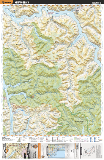
CCBC48 Kemano Beach - Cariboo Chilcotin Coast BC Topo
This recreation topographic map for the Kemano Beach area highlights all the logging roads, trails and recreational Points of Interest including hunting, camping, hiking, mountain biking, canoeing, kayaking, backcountry skiing, wildlife viewing, ATVing, snowmobiling and more. No other map provides you with this level of recreational and topographic detail for the Homathko River area. Covering the Kemano Beach, Europa Lake Conservancy, Q'altanaas/Aaltanhash Conservancy, K'ootz/Khutze Conservancy, Fiordland Conservancy, Europa Lake, Yule Lake, Gardner Canal, Princess Royal Channel and more, this map contains new features such as private land and labelled fish species. The 1:85,000 scale map covers 3,040 km2 (1,175 mi2), measuring 50 x 63.5 km (30 x 39.5 mi).
Page Size: 24 x 37 in (610 x 940 mm)
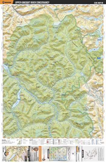
CCBC49 Upper Kimsquit River Conservancy - Cariboo Chilcotin Coast BC Topo
This recreation topographic map for the Upper Kimsquit River Conservancy area highlights all the logging roads, trails and recreational Points of Interest including hunting, camping, hiking, mountain biking, canoeing, kayaking, backcountry skiing, wildlife viewing, ATVing, snowmobiling and more. No other map provides you with this level of recreational and topographic detail for the Homathko River area. Covering the Huchsduwachsdu Nuyem Jees/Kitlope Heritage Conserv, Upper Kimsquit River Conservancy, Tweedsmuir Park, Kitlope Lake, Little Whitesail Lake and more, this map contains new features such as private land and labelled fish species. The 1:85,000 scale map covers 3,040 km2 (1,175 mi2), measuring 50 x 63.5 km (30 x 39.5 mi).
Page Size: 24 x 37 in (610 x 940 mm)
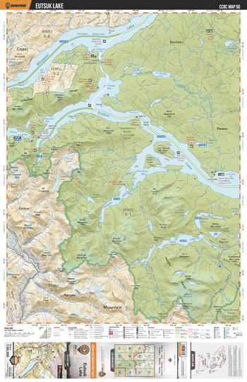
CCBC50 Eutsuk Lake - Cariboo Chilcotin Coast BC Topo
This recreation topographic map for the Eutsuk Lake area highlights all the logging roads, trails and recreational Points of Interest including hunting, camping, hiking, mountain biking, canoeing, kayaking, backcountry skiing, wildlife viewing, ATVing, snowmobiling and more. No other map provides you with this level of recreational and topographic detail for the Homathko River area. Covering the Whitesail Lake, Eutsuk Lake, Tweedsmuir Prov Park, Tesla Lake, Pondosy Lake, Musclow Lake, Surel Lake, St Thomas Lake, St Thomas River, Redfish Lake and more, this map contains new features such as private land and labelled fish species. The 1:85,000 scale map covers 3,040 km2 (1,175 mi2), measuring 50 x 63.5 km (30 x 39.5 mi).
Page Size: 24 x 37 in (610 x 940 mm)
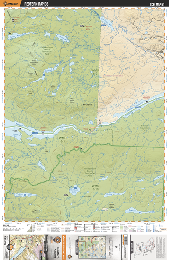
CCBC51 Redfern Rapids - Cariboo Chilcotin Coast BC Topo
This recreation topographic map for the Redfern Rapids area highlights all the logging roads, trails and recreational Points of Interest including hunting, camping, hiking, mountain biking, canoeing, kayaking, backcountry skiing, wildlife viewing, ATVing, snowmobiling and more. No other map provides you with this level of recreational and topographic detail for the Homathko River area. Covering the Tweedsmuir Prov Park, Eutsuk Lake, Tetachuck Lake, Nechako Plateau, Entiako Protected Area, Blanchet Lake, Fenton Lake, Chezko River, Nahlouza Lake, Qualcho Lake and more, this map contains new features such as private land and labelled fish species. The 1:85,000 scale map covers 3,040 km2 (1,175 mi2), measuring 50 x 63.5 km (30 x 39.5 mi).
Page Size: 24 x 37 in (610 x 940 mm)
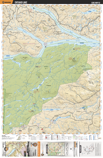
CCBC52 Entiako Lake - Cariboo Chilcotin Coast BC Topo
This recreation topographic map for the Entiako Lake area highlights all the logging roads, trails and recreational Points of Interest including hunting, camping, hiking, mountain biking, canoeing, kayaking, backcountry skiing, wildlife viewing, ATVing, snowmobiling and more. No other map provides you with this level of recreational and topographic detail for the Homathko River area. Covering the Entiako Prov Park, Entiako Lake, Moose Lake, Natalkuz Lake, Tetachuck Lake, Entiako Protected Area, Chelaslie Arm, Intata Reach, Lucas Lake, Entiako River and more, this map contains new features such as private land and labelled fish species. The 1:85,000 scale map covers 3,040 km2 (1,175 mi2), measuring 50 x 63.5 km (30 x 39.5 mi).
Page Size: 24 x 37 in (610 x 940 mm)
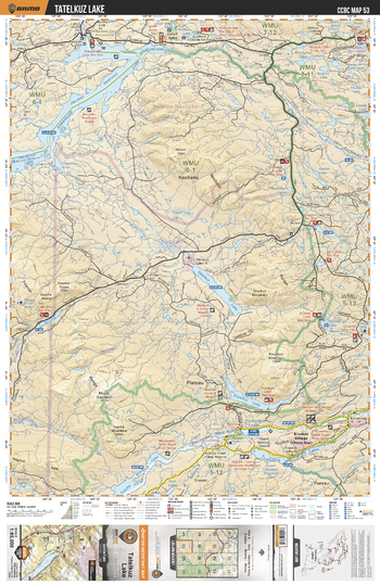
CCBC53 Tatelkuz Lake - Cariboo Chilcotin Coast BC Topo
This recreation topographic map for the Tatelkuz Lake area highlights all the logging roads, trails and recreational Points of Interest including hunting, camping, hiking, mountain biking, canoeing, kayaking, backcountry skiing, wildlife viewing, ATVing, snowmobiling and more. No other map provides you with this level of recreational and topographic detail for the Homathko River area. Covering the Knewstubb Lake, Natalkuz Lake, Tatelkuz Lake, Kuyakuz Lake, Tsacha Lake, Kluskus Lakes, Top Lake, Big Bend Arm, Euchiniko Lakes, Kluskus Village and more, this map contains new features such as private land and labelled fish species. The 1:85,000 scale map covers 3,040 km2 (1,175 mi2), measuring 50 x 63.5 km (30 x 39.5 mi).
Page Size: 24 x 37 in (610 x 940 mm)
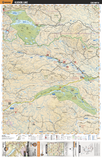
CCBC54 Kluskoil Lake - Cariboo Chilcotin Coast BC Topo
This recreation topographic map for the Kluskoil Lake area highlights all the logging roads, trails and recreational Points of Interest including hunting, camping, hiking, mountain biking, canoeing, kayaking, backcountry skiing, wildlife viewing, ATVing, snowmobiling and more. No other map provides you with this level of recreational and topographic detail for the Homathko River area. Covering the Finger Tatuk Prov Park, Tatuk Lake, Finger Lake, Kluskoil Lake, Euchiniko Lakes, Kluskoil Lake Prov Park, Titetown Lake, Blackwater River, Euchiniko River, Batnuni Lake and more, this map contains new features such as private land and labelled fish species. The 1:85,000 scale map covers 3,040 km2 (1,175 mi2), measuring 50 x 63.5 km (30 x 39.5 mi).
Page Size: 24 x 37 in (610 x 940 mm)
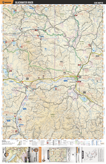
CCBC55 Blackwater River - Cariboo Chilcotin Coast BC Topo
This recreation topographic map for the Blackwater River area highlights all the logging roads, trails and recreational Points of Interest including hunting, camping, hiking, mountain biking, canoeing, kayaking, backcountry skiing, wildlife viewing, ATVing, snowmobiling and more. No other map provides you with this level of recreational and topographic detail for the Homathko River area. Covering the Blackwater River, Punchaw Lake, Lintz Lake, Pantage Lake, Chilako River, Euchiniko River, Barton Lake, Nazko River, Blackwater, Boot Lake and more, this map contains new features such as private land and labelled fish species. The 1:85,000 scale map covers 3,040 km2 (1,175 mi2), measuring 50 x 63.5 km (30 x 39.5 mi).
Page Size: 24 x 37 in (610 x 940 mm)
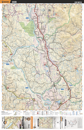
CCBC56 Hixon - Cariboo Chilcotin Coast BC Topo
This recreation topographic map for the Hixon area highlights all the logging roads, trails and recreational Points of Interest including hunting, camping, hiking, mountain biking, canoeing, kayaking, backcountry skiing, wildlife viewing, ATVing, snowmobiling and more. No other map provides you with this level of recreational and topographic detail for the Homathko River area. Covering the Hixon, Ten Mile Lake, Fraser River Prov Park, Fraser River, Three Sisters Lakes Prov Park, Genevieve Lake, MacKenzie Lakes, Chubb Lake, Colebank, Crysdale and more, this map contains new features such as private land and labelled fish species. The 1:85,000 scale map covers 3,040 km2 (1,175 mi2), measuring 50 x 63.5 km (30 x 39.5 mi).
Page Size: 24 x 37 in (610 x 940 mm)
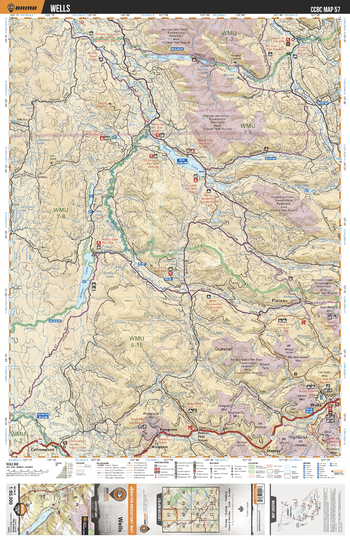
CCBC57 Wells - Cariboo Chilcotin Coast BC Topo
This recreation topographic map for the Wells area highlights all the logging roads, trails and recreational Points of Interest including hunting, camping, hiking, mountain biking, canoeing, kayaking, backcountry skiing, wildlife viewing, ATVing, snowmobiling and more. No other map provides you with this level of recreational and topographic detail for the Homathko River area. Covering the Wells, Ahbau Lake, Pine Grove, Cottonwood, Stony Lake, Narrow Lake, Bowron River, Two Sisters Mtn, Cow Mtn, Willow River and more, this map contains new features such as private land and labelled fish species. The 1:85,000 scale map covers 3,040 km2 (1,175 mi2), measuring 50 x 63.5 km (30 x 39.5 mi).
Page Size: 24 x 37 in (610 x 940 mm)
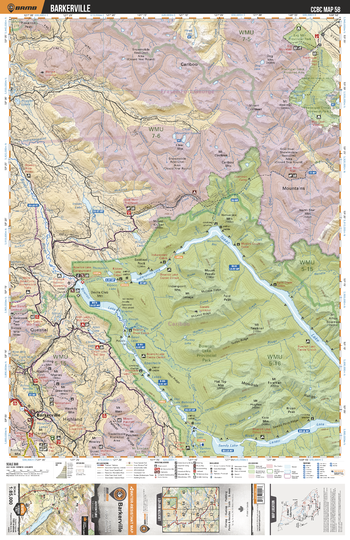
CCBC58 Barkerville - Cariboo Chilcotin Coast BC Topo
This recreation topographic map for the Barkerville area highlights all the logging roads, trails and recreational Points of Interest including hunting, camping, hiking, mountain biking, canoeing, kayaking, backcountry skiing, wildlife viewing, ATVing, snowmobiling and more. No other map provides you with this level of recreational and topographic detail for the Homathko River area. Covering the Bowron Lake Prov Park, Barkerville, Swan Lake, Sandy Lake, Isaac Lake, Lanezi Lake, Bowron Lake, Indianpoint Lake, Bowron River, Ptarmingan Creek Prov Park and more, this map contains new features such as private land and labelled fish species. The 1:85,000 scale map covers 3,040 km2 (1,175 mi2), measuring 50 x 63.5 km (30 x 39.5 mi).
Page Size: 24 x 37 in (610 x 940 mm)
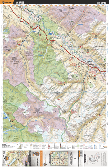
CCBC59 McBride - Cariboo Chilcotin Coast BC Topo
This recreation topographic map for the McBride area highlights all the logging roads, trails and recreational Points of Interest including hunting, camping, hiking, mountain biking, canoeing, kayaking, backcountry skiing, wildlife viewing, ATVing, snowmobiling and more. No other map provides you with this level of recreational and topographic detail for the Homathko River area. Covering the West Twin Prov Park, Bowron Lake Prov Park, Cariboo River, Castle Creek, Fraser River, McBride, La Salle Lakes, Lamming Mills, Goat River, McKale River and more, this map contains new features such as private land and labelled fish species. The 1:85,000 scale map covers 3,040 km2 (1,175 mi2), measuring 50 x 63.5 km (30 x 39.5 mi).
Page Size: 24 x 37 in (610 x 940 mm)
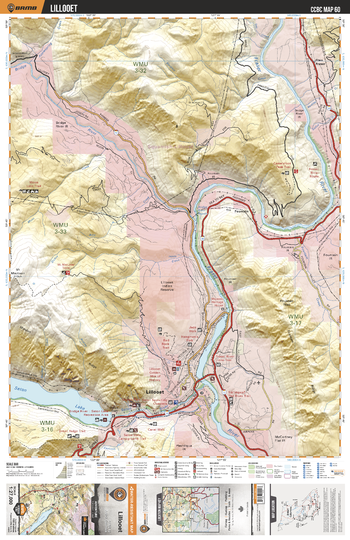
CCBC60 Lillooet - Cariboo Chilcotin Coast BC Topo
This recreation topographic map for the Lillooet area highlights all the logging roads, trails and recreational Points of Interest including hunting, camping, hiking, mountain biking, canoeing, kayaking, backcountry skiing, wildlife viewing, ATVing, snowmobiling and more. No other map provides you with this level of recreational and topographic detail for the Homathko River area. Covering the Lillooet, Seton Lake Recreation Area and more, this map contains new features such as leased and private land.
Page Size: 24 x 37 in (610 x 940 mm)