A-Z Maps
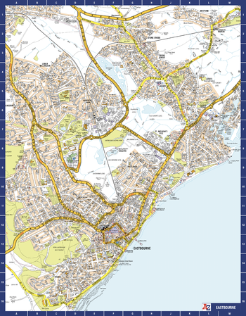
Eastbourne A-Z Street Map
The perfect reference map for finding your way around Eastbourne. This up-to-date detailed A-Z town plan includes 1,500 streets in and around Eastbourne. As well as the Eastbourne Pier the other areas covered are Birling Gap, Beachy Head, Hailsham, Polegate, Pevensey Bay, Willingdon, Langney, East Dean and Friston. The highly detailed 1 mile to 5.5 inch street map includes places of interest, among other features.
Page Size: 22.25 x 28.5 in (560 x 718 mm)
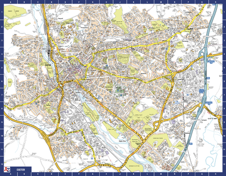
Exeter A-Z Street Map
The perfect reference map for finding your way around Exeter. This up-to-date detailed A-Z town plan includes over 2,100 streets in and around Exeter. As well as the central area of the University colleges and Cathedral, the other areas covered are Larkbeare, Friars Green, Barnfield, St Thomas and St David’s. The highly detailed 1 mile to 5.5 inch street map includes places of interest, among other features.
Page Size: 28.5 x 22.25 in (718 x 560 mm)
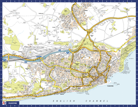
Folkestone A-Z Street Map
The perfect reference map for finding your way around Folkstone. This up-to-date detailed A-Z town plan includes more than 1,000 streets in and around Folkestone. Detailed coverage of an area extending from Hawkinge to Sandgate in the south, and from East Wear Bay in the east to Newington in the west. The highly detailed 1 mile to 4.5 inch street map includes places of interest, among other features.
Page Size: 28.5 x 22.25 in (718 x 560 mm)
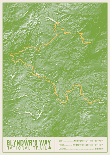
Glyndwr's Way National Trail Map Print
This map print highlights the National Trail route of the Glyndwr's Way, showing the start and finish points on an attractive relief base and created in the official National Trail colours.
Page Size: 16.75 x 23.5 in (420 x 594 mm)
Great Britain A-Z Road Map
The Great Britain A-Z road map is a detailed full colour road map of Great Britain. The following features are shown on the road mapping: motorways with full junction detail; service areas; primary routes and destinations; A & B roads, selected minor roads; gradients 1:5 and steeper; tolls; mileages; national and county boundaries; and spot heights. A wide range of ancillary and tourist information, including points of interest such as golf courses, castles and country parks are included on the map.
Great Britain A-Z Street Map
The Great Britain A-Z Street Map provides street level coverage for all of England. Scotland coverage includes the corridor between Edinburgh-Glasgow-Greenock, Perth, Dundee, Aberdeen and Inverness, as well as select smaller localities. Coverage in Wales includes South Wales, and Caernarfon, Bangor, Conwy and Llandudno in the north.The full colour street mapping has a wealth of information, including one-way streets, walking and bicycle paths, National Rail and London Underground stations, and River Bus piers. Selected places of interest identified on the map include theatres, cinemas, museums and tourist attractions.
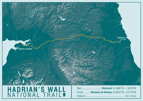
Hadrian's Wall Path National Trail Map Print
This map print highlights the National Trail route of the Hadrian's Wall Path, showing the start and finish points on an attractive relief base and created in the official National Trail colours.
Page Size: 23.5 x 16.75 in (594 x 420 mm)
Historical London
This historical mapping of central London is made up from extracts of hand drawn pen and ink street map originals. This mapping, which includes bus, trolleybus and tram routes, shows the streets of London as they were just before the Second World War.
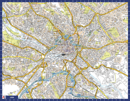
Leeds A-Z Street Map
The perfect reference map for finding your way around Leeds. This up-to-date detailed A-Z town plan includes 4,555 streets in and around Leeds. As well as the University of Leeds, the other areas covered are Hyde Park, Holbeck, Leeds Dock and Little London. The highly detailed 1 mile to 5.5 inch street map includes places of interest, among other features.
Page Size: 28.5 x 22.25 in (718 x 560 mm)
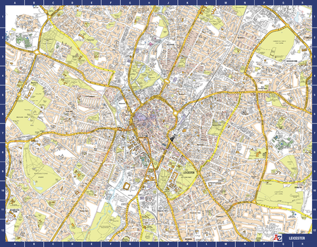
Leicester A-Z Street Map
The perfect reference map for finding your way around Leicester. This up-to-date detailed A-Z town plan includes more than 2,000 streets in and around Leicester. As well as the city centre and Leicester Cathedral, the other areas covered include Braunstone Town, Victoria Park, Evington, Humberstone, Belgrave and Glenfield Hospital. The highly detailed 1 mile to 5.5 inch street map includes places of interest, among other features.
Page Size: 28.5 x 22.25 in (718 x 560 mm)
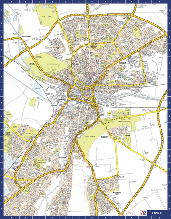
Lincoln A-Z Street Map
The perfect reference map for finding your way around Lincoln. This up-to-date detailed A-Z town plan includes more than 1,000 streets in and around Lincoln.
As well as Lincoln Castle and Lincoln Cathedral, the other areas covered include Bracebridge Low Fields, Boultham Moor, South Common, Canwick, West Common and St Giles. The highly detailed 1 mile to 5.5 inch street map includes places of interest, among other features.
Page Size: 22.25 x 28.5 in (560 x 718 mm)
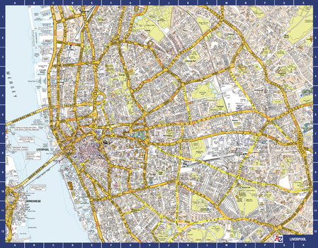
Liverpool A-Z Street Map
The perfect reference map for finding your way around Liverpool. This up-to-date detailed A-Z town plan includes all of the 2,000 streets in and around Liverpool. As well as the city centre other areas covered are Baltic Triangle, Ropewalks, Vauxhall, Fairfield, Weavertree and Walton. The highly detailed 1 mile to 5.5 inch street map includes places of interest, among other features.
Page Size: 28.5 x 22.25 in (718 x 560 mm)
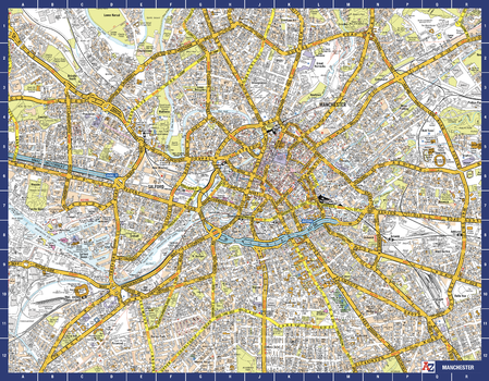
Manchester A-Z Street Map
The perfect reference map for finding your way around Manchester. This up-to-date detailed A-Z town plan includes more than 4,500 streets in and around Manchester. As well as the Northern Quarter and Spinningfields, the other areas covered include Moss Side, Ordsall, Weaste, Salford, Seedley, Lower Kersal, Strangeways, Miles Platting and West Gorton. The highly detailed 1 mile to 5.5 inch street map includes places of interest, among other features.
Page Size: 28.5 x 22.25 in (718 x 560 mm)
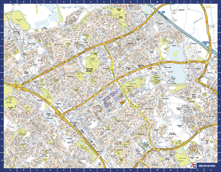
Milton Keynes A-Z Street Map
The perfect reference map for finding your way around Milton Keynes. This up-to-date detailed A-Z town plan includes more than 1,500 streets in and around Milton Keynes. As well as Central Milton Keynes, the other areas covered include Shenley Church End, Walton Hall, Monkston, Willen Lake, Pennyland, Great Linford, Bradville and Heelands. The highly detailed 1 mile to 5.5 inch street map includes places of interest, among other features.
Page Size: 28.5 x 22.25 in (718 x 560 mm)
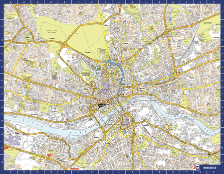
Newcastle A-Z Street Map
The perfect reference map for finding your way around Newcastle-upon-Tyne. This up-to-date detailed A-Z town plan includes 1,500 streets in and around Newcastle upon Tyne. As well as the city centre the other areas covered are Ouesburn, Jesmond, Quayside, Grainger Town and Spital Tongues. The highly detailed 1 mile to 5.5 inch street map includes places of interest, among other features.
Page Size: 28.5 x 22.25 in (718 x 560 mm)
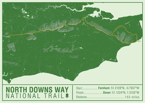
North Downs Way National Trail Map Print
This map print highlights the National Trail route of the North Downs Way, showing the start and finish points on an attractive relief base and created in the official National Trail colours.
Page Size: 23.5 x 16.75 in (594 x 420 mm)
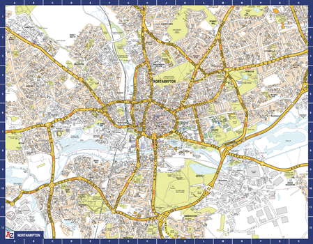
Northampton A-Z Street Map
The perfect reference map for finding your way around Northampton. This up-to-date detailed A-Z town plan includes more than 2,300 streets in and around Northampton. The highly detailed 1 mile to 4.5 inch street map includes places of interest, among other features.
Page Size: 28.5 x 22.25 in (718 x 560 mm)
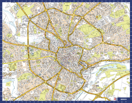
Norwich A-Z Street Map
The perfect reference map for finding your way around Norwich. This up-to-date detailed A-Z town plan includes more than 2,000 streets in and around Norwich. As well as the Norwich Cathedral and central Norwich, the other areas covered include Cringleford, Lakenham, Whitlingham Country Park, Thorpe St Andrew, New Catton and Hellesdon. The highly detailed 1 mile to 5.5 inch street map includes places of interest, among other features.
Page Size: 28.5 x 22.25 in (718 x 560 mm)
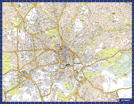
Nottingham A-Z Street Map
The perfect reference map for finding your way around Nottingham. This up-to-date detailed A-Z town plan includes more than 3,000 streets in and around Nottingham.
As well as Nottingham Castle and Lace Market, the other areas covered include Willford Village, Dunkirk, the Meadows, New Lenton, Old Radford, Thorneywood, Alexandra Park, Aspley, Forest Fields, Highbury Vale and Woodthorpe. The highly detailed 1 mile to 5.5 inch street map includes places of interest, among other features.
Page Size: 28.5 x 22.25 in (718 x 560 mm)
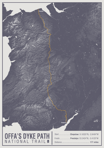
Offa's Dyke Path National Trail Map Print
This map print highlights the National Trail route of the Offa's Dyke Path, showing the start and finish points on an attractive relief base and created in the official National Trail colours.
Page Size: 16.75 x 23.5 in (420 x 594 mm)