A-Z Maps

50 Miles around Birmingham Road Map
A-Z Road Map of Birmingham covers and area extending to: Chester, Congleton, Bakewell, Mansfield, Newark-on-Trent, Corby, Northampton, Milton Keynes, Aylesbury, Oxford, Cirencester, Monmouth, Hereford, Bishop's Castle, Oswestry and Wrexham.
Page Size: 49.25 x 34.5 in (1250 x 871 mm)

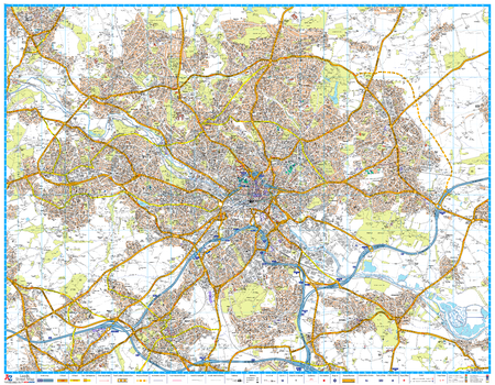
50 Miles around Manchester Road Map
A-Z Road Map of Manchester covers an area extending to: Barrow-in-Furness, Kirby Lonsdale, Ripon, York, Selby, Doncaster, Worksop, Mansfield, Nottingham, Loughborough, Cannock, Telford, Shrewsbury, Llangadfan, Rhyll, Birkenhead, Liverpool, Southport, Blackpool, Fleetwood and Lancaster.
Page Size: 48.5 x 34.5 in (1228 x 871 mm)
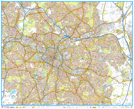
A-Z Birmingham Street Map
A-Z Street Map of Birmingham. This map covers The National Exhibition Centre, Birmingham International Airport, Solihull (part), Yardley Wood (part), Birmingham, Smethwick, West Bromwich, Wednesbury (part), Castle Bromwich, Quinton
Page Size: 46.5 x 38 in (1180 x 960 mm)

A-Z Cardiff Street Map
A-Z Street Map of Cardiff. This map covers Cardiff, Cardiff Bay & Docks, Dinas Powys, Ely (Trelái), LLandaff,Llanishen (Llanisien), Marshfield (Maerun), Michaelston-super-Ely, Morganstown (Treforgan), Penarth, Pentyrch, Radyr (Radur), Rumney (Rhymni), St Fagans (Sain Ffagan), St Mellons, Thornhill, Wenvoe (Gwenfô), Whitchurch (Yr Eglwys Newydd).
Page Size: 46.75 x 37.75 in (1184 x 954 mm)

A-Z Central England and Wales Road Map
This A-Z Road Map of Central England and Wales is a full colour, single-sided road map featuring continuous mapping from Bristol and Reading in the south to Blackpool and Leeds in the north, and from Peterborough in the east to include the whole of Wales in the west.
Page Size: 45.75 x 35.75 in (1157 x 907 mm)

A-Z Coventry Street Map
A-Z Street Map of Coventry. This map covers Keresley Newlands, Coventry, M6 Junction 3, Walsgrave on Stowe, Binley Woods, Ryton-on-Dunsmore, Coventry Airport, Millison's Wood, Tile Hill
Page Size: 45 x 39.5 in (1138 x 1000 mm)
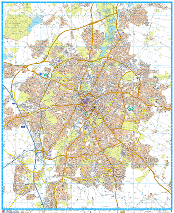
A-Z Leeds Street Map
A-Z Street Map of Leeds. This map covers Alwoodley, Beeston, Birkenshaw, Birstall (part), Bramley, Calverley, Colton, Cross Gates, Drighlington, Farsley, Gildersome, Harehills, Headingley, Horsforth, Leeds, Meanwood, Middleton, Morley, New Farnley, Oulton, Pudsey, Rawdon, Rothwell, Roundhay, Scholes, Swillington, Thorner, Woodlesford, Wortley, Yeadon (part). First edition, published August 2016.
Page Size: 46.75 x 36.25 in (1184 x 920 mm)
A-Z Leicester Street Map
A-Z Street Map of Leicester. This map covers Anstey, Belgrave, Birstall, Blaby, Braunstone Town, Cropston, Enderby, Glenfield, Glen Parva, Groby (part), Leicester, Narborough, Oadby, Syston, Thurcaston, Thurmaston, Wigston. First edition, published August 2016.
Page Size: 38.25 x 46.75 in (967 x 1184 mm)

A-Z Liverpool Street Map
A-Z Street Map of Liverpool. This map covers Aintree, Bidston, Birkenhead, Bootle, Childwall, Crosby, Halewood, Huyton, Huyton-with-Roby, Kirkby (part), Knowsley, Litherland, Liverpool, New Brighton, Prenton, Tranmere, Upton. Wallasey, Walton
Page Size: 46.75 x 37 in (1184 x 940 mm)
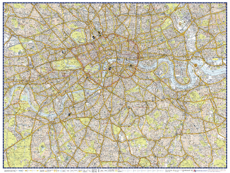
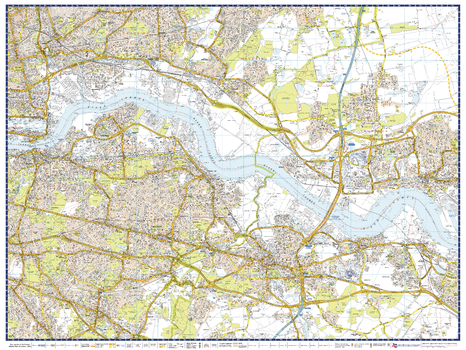
A-Z London Master Plan - Centre
A-Z Street Map of Central London. This Master Plan is one of a series of 9 street maps covering the Greater London area, which can be joined and mounted for display. Featuring A-Z's iconic street mapping, these maps include postcode district and local authority boundaries.
Page Size: 40 x 30.25 in (1015 x 763 mm)
A-Z London Master Plan - East
A-Z Street Map of East London. This Master Plan is one of a series of 9 street maps covering the Greater London area, which can be joined and mounted for display. Featuring A-Z's iconic street mapping, these maps include postcode district and local authority boundaries.
Page Size: 40 x 30.25 in (1015 x 763 mm)

A-Z London Master Plan - North
A-Z Street Map of North London. This Master Plan is one of a series of 9 street maps covering the Greater London area, which can be joined and mounted for display. Featuring A-Z's iconic street mapping, these maps include postcode district and local authority boundaries.
Page Size: 40 x 30.25 in (1015 x 763 mm)
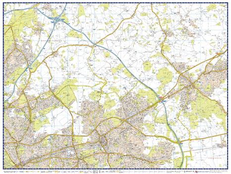
A-Z London Master Plan - North East
A-Z Street Map of North East London. This Master Plan is one of a series of 9 street maps covering the Greater London area, which can be joined and mounted for display. Featuring A-Z's iconic street mapping, these maps include postcode district and local authority boundaries.
Page Size: 40 x 30.25 in (1015 x 763 mm)

A-Z London Master Plan - North West
A-Z Street Map of North West London. This Master Plan is one of a series of 9 street maps covering the Greater London area, which can be joined and mounted for display. Featuring A-Z's iconic street mapping, these maps include postcode district and local authority boundaries.
Page Size: 40 x 30.25 in (1015 x 763 mm)
A-Z London Master Plan - South
A-Z Street Map of South West London. This Master Plan is one of a series of 9 street maps covering the Greater London area, which can be joined and mounted for display. Featuring A-Z's iconic street mapping, these maps include postcode district and local authority boundaries.
Page Size: 40 x 30.25 in (1015 x 763 mm)
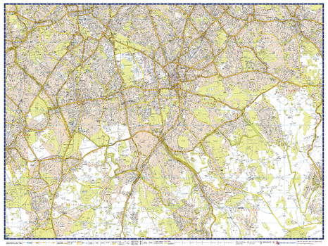
A-Z London Master Plan - South East
A-Z Street Map of South East London. This Master Plan is one of a series of 9 street maps covering the Greater London area, which can be joined and mounted for display. Featuring A-Z's iconic street mapping, these maps include postcode district and local authority boundaries.
Page Size: 40 x 30.25 in (1015 x 763 mm)

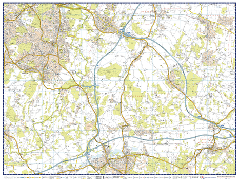
A-Z London Master Plan - South West
A-Z Street Map of South West London. This Master Plan is one of a series of 9 street maps covering the Greater London area, which can be joined and mounted for display. Featuring A-Z's iconic street mapping, these maps include postcode district and local authority boundaries.
Page Size: 40 x 30.25 in (1015 x 763 mm)

A-Z London Master Plan - West
A-Z Street Map of West London. This Master Plan is one of a series of 9 street maps covering the Greater London area, which can be joined and mounted for display. Featuring A-Z's iconic street mapping, these maps include postcode district and local authority boundaries.
Page Size: 40 x 30.25 in (1015 x 763 mm)
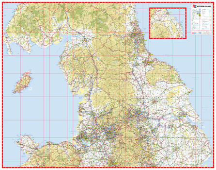
A-Z Northern England Road Map
This A-Z Road Map of Northern England is a full colour, single-sided road map featuring continuous mapping from Stoke-on-Trent in the south to Alnwick in the north and the Isle of Man in the west to Skegness on the east coast. An inset map extends coverage northwards to include Berwick-Upon-Tweed, Holy Island and Seahouses.
Page Size: 45.75 x 35.75 in (1157 x 907 mm)

A-Z Plymouth Street Map
A-Z Street Map of Plymouth. This map covers Plymouth, Tamerton Foliot, Southway, Roborough, Derriford, Woodford, Plympton, Brixton, Plymstock, Devonport, St.Budeaux
Page Size: 47 x 37.75 in (1189 x 957 mm)